Home › California › Public land › National forests › Eldorado NF

National forest · 2026-27

Eldorado National Forest Hunting Access, Dates and Rules

National forest in El Dorado County and 3 more counties with 615,037 acres, run by the US Forest Service.

Hunting gear

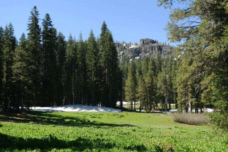
The page header carries a genuine photo of Eldorado National Forest.

Photo: Mark Doliner (CC BY-SA 2.0)

Getting to Eldorado National Forest

Parking, trailheads and gates near Eldorado National Forest

  • Parking areaParking · 1.7 mi from the centreDirections
  • Parking areaParking · 1.8 mi from the centreDirections
  • Parking areaParking · 1.8 mi from the centreDirections
  • Parking areaParking · 2.3 mi from the centreDirections
  • Parking areaParking · 2.7 mi from the centreDirections
  • Parking areaParking · 2.7 mi from the centreDirections
  • Parking areaParking · 3.0 mi from the centreDirections
  • Parking areaParking · 3.1 mi from the centreDirections
  • Boat rampBoat ramp · 3.1 mi from the centreDirections
  • Boat rampBoat ramp · 3.1 mi from the centreDirections
  • Parking areaParking · 3.1 mi from the centreDirections
  • Parking areaParking · 3.3 mi from the centreDirections

Parking, trailhead and gate locations come from OpenStreetMap contributors. Roads into public land can be gated or seasonal; check with the managing agency before you go.

Who runs Eldorado National Forest and what it is

Hunters find Eldorado National Forest across 4 counties including El Dorado County, Amador County and Placer County, where the US Forest Service runs a national forest open to the public. Eldorado National Forest totals about 615,037 acres by the agency figure. Hunting on national forest ground follows CDFW seasons, with the Forest Service setting conduct rules.

615,037Acres
Forest ServiceNational forest
4Counties
4Districts

Sources: Forest Service page · Forest Service page 2 · Forest Service page 3. Checked November 15, 2026.

Nearby

Places to hunt and shoot around Eldorado National Forest

Tahoe National Forest

Public land · 43 mi from Eldorado National Forest

Directions
Stanislaus National Forest

Public land · 46 mi from Eldorado National Forest

Directions
Shooting Ranges Near Sacramento

Range · 62 mi from Eldorado National Forest

Directions
Hunting Near Sacramento, California

Town · 62 mi from Eldorado National Forest

Directions
Plumas National Forest

Public land · 83 mi from Eldorado National Forest

Directions
Grizzly Island Wildlife Area

Public land · 98 mi from Eldorado National Forest

Directions

The paperwork side of Eldorado National Forest

The forest hunting page lists the conditions for Eldorado National Forest; read it with the CDFW booklet beside it.

A California hunting license is the base requirement: $64.54 for residents and $225.46 for nonresidents, valid July 1, 2026 – June 30, 2027 (CDFW fee page, checked November 15, 2026).

Forest Service hunting page

Hunting is licensed through California Department of Fish & Wildlife Hunting is seasonal and the rules are simple: Follow the state laws and regulations pertaining to hunting to including seasons, dates and licensing.

Sources: Forest Service page; license fees from the CDFW fee page. Checked November 15, 2026.

Tag zones and Eldorado National Forest

Deer tags are tied to zones, and the 2014 layer lays 2 zones across Eldorado National Forest.

Deer zoneOverlapTag kindSeason window
Zone D-591%UnrestrictedSep 26–Nov 1
Zone D-49%UnrestrictedSep 26–Nov 1

Zone overlaps from the CDFW deer zone layer (2014) and waterfowl zone layer; zone sheets at CDFW deer zones; season dates from the 2026-27 booklet. Checked November 15, 2026. Deer zone and waterfowl zone overlaps on land records come from the CDFW deer zone layer dated 2014 and the waterfowl zone layer, so treat them as approximate.

The district list for Eldorado National Forest

Pick a district below: Eldorado National Forest splits into 4 ranger districts.

DistrictSize (acres)Counties
Amador Ranger District196,002Amador, Alpine
Georgetown Ranger District193,247El Dorado, Placer
Pacific Ranger District199,601El Dorado, Placer
Placerville Ranger District205,916El Dorado

District list from the Forest Service hunting page and the Forest Service ranger district layer. Checked November 15, 2026.

The counties behind Eldorado National Forest

The record places Eldorado National Forest across 4 counties, and the table sets out the rules that follow from the county. No county sits wholly inside one deer zone; the count shows how many zones touch it.

CountyApprox. shareRegionZones touchingCWD status
El Dorado County71%North Central2 zonesNone reported
Amador County11%North Central1 zoneNone reported
Placer County11%North Central4 zonesNone reported
Alpine County7%North Central3 zonesNone reported

Per the CDFW CWD page read on November 15, 2026, the disease is confirmed only in Inyo and Madera counties, not here.

The two county tables CDFW publishes cover bears in 2024 and wild pigs in 2024-25; matching rows follow.

CountyBear 2024Wild pig 2024-25
El Dorado County42–
Amador County83
Placer County221
Alpine County19–

Bear take from the CDFW black bear hunter take report; pig take from the CDFW wild pig report. Checked November 15, 2026.

County and CWD data from CDFW and the 2026-27 mammal booklet; county shares from Forest Service page · Forest Service page 2. Checked November 15, 2026.

Location and contact for Eldorado National Forest

The pin on this page is a generalized point taken from the Forest Service boundary layer, so it marks the area and not a gate. Drive in from Pollock Pines (13 miles west), Grizzly Flats (14 miles southwest) and Kirkwood (18 miles east), whichever is closest to your route. Closest agency office: North Central Region (Region 2) main office, Rancho Cordova, 48 miles by straight line, phone (916) 358-2900.

Sources: Forest Service page · Forest Service page 2 · Forest Service page 3; point from the Forest Service boundary layer; offices from the CDFW regions page. Checked November 15, 2026.

El Dorado County season calendar, 2026-27

Every dated season whose CDFW sheet reaches El Dorado County is listed below, and deer rows name the zone because a zone covers only part of a county.

SpeciesWindowPaperworkReachFirstLastToday?
DeerArcheryDeer tagZones D3 to D5Aug 15, 2026Sep 6, 2026
DeerGeneralDrawn tagZone X8Sep 26, 2026Oct 11, 2026
DeerGeneralDeer tagZones D3 to D5Sep 26, 2026Nov 1, 2026
Black bearArcheryBear tagAll bear hunt areasAug 15, 2026Sep 6, 2026
Black bearGeneralBear tagDeer zones X1 through X7bOct 10, 2026Dec 27, 2026
Wild pigGeneralPig validationStatewideJul 1, 2026Jun 30, 2027
Wild turkeyFallUpland validationStatewideNov 14, 2026Dec 13, 2026
Wild turkeySpring additional juniorUpland validationStatewideMar 20, 2027Mar 21, 2027
Wild turkeySpringUpland validationStatewideMar 27, 2027May 2, 2027
Wild turkeySpring additional juniorUpland validationStatewideMay 3, 2027May 16, 2027
Wild turkeySpring archeryUpland validationStatewideMay 3, 2027May 16, 2027
Tree squirrelArchery, falconryHunting licenseCounties in T14 CCR 307Aug 1, 2026Sep 11, 2026
Tree squirrelGeneralHunting licenseTree squirrel general seasonSep 12, 2026Jan 31, 2027
Rabbit and hareGeneralHunting licenseStatewideJul 1, 2026Jan 31, 2027
Rabbit and hareFalconryHunting licenseStatewideFeb 1, 2027Mar 21, 2027
JackrabbitGeneralHunting licenseStatewideJul 1, 2026Jun 30, 2027
PheasantFalconryUpland validationStatewideAug 15, 2026Feb 28, 2027
PheasantArcheryUpland validationStatewideOct 10, 2026Nov 1, 2026
PheasantGeneralUpland validationStatewideNov 14, 2026Dec 27, 2026
PheasantArcheryUpland validationStatewideDec 28, 2026Jan 24, 2027
ChukarArcheryUpland validationStatewideAug 15, 2026Sep 4, 2026
ChukarFalconryUpland validationStatewideAug 15, 2026Feb 28, 2027
ChukarGeneralUpland validationStatewideOct 17, 2026Jan 31, 2027
DoveGeneralUpland validationStatewideSep 1, 2026Sep 15, 2026
DoveGeneralUpland validationStatewideNov 14, 2026Dec 28, 2026
Spotted doveGeneralUpland validationStatewideSep 1, 2026Sep 15, 2026
Spotted doveGeneralUpland validationStatewideNov 14, 2026Dec 28, 2026
Collared doveGeneralUpland validationStatewideJul 1, 2026Jun 30, 2027
SnipeGeneralUpland validationStatewideOct 17, 2026Jan 31, 2027
Nongame mammalsGeneralHunting licenseStatewideJul 1, 2026Jun 30, 2027

Wildlife areas can shorten or close these dates.

From the 2026-27 CDFW mammal hunting booklet and the waterfowl, upland game and lands booklet (California Department of Fish and Wildlife), checked November 15, 2026.

The Eldorado National Forest hours table, opener by opener

Deer and other big game may be taken from half an hour before sunrise until half an hour after sunset, and the Eldorado National Forest figures below come from the NOAA solar formula.

WhenEventFirst lightLast lightDeer legalMigratory legal
Aug 15, 2026Deer archery opens6:15 a.m.7:58 p.m.5:45 a.m. to 8:28 p.m.5:45 a.m. to 7:58 p.m.
Sep 1, 2026Dove opens6:30 a.m.7:34 p.m.6:00 a.m. to 8:04 p.m.6:00 a.m. to 7:34 p.m.
Sep 26, 2026Deer general opens6:51 a.m.6:54 p.m.6:21 a.m. to 7:24 p.m.6:21 a.m. to 6:54 p.m.
Oct 17, 2026Chukar opens7:11 a.m.6:22 p.m.6:41 a.m. to 6:52 p.m.6:41 a.m. to 6:22 p.m.
Nov 14, 2026Fall turkey opens and pheasant opens6:42 a.m.4:50 p.m.6:12 a.m. to 5:20 p.m.6:12 a.m. to 4:50 p.m.
Nov 21, 2026Free hunting day6:50 a.m.4:45 p.m.6:20 a.m. to 5:15 p.m.6:20 a.m. to 4:45 p.m.
Dec 21, 2026Year's shortest day7:16 a.m.4:43 p.m.6:46 a.m. to 5:13 p.m.6:46 a.m. to 4:43 p.m.
Mar 27, 2027Spring turkey opens6:56 a.m.7:19 p.m.6:26 a.m. to 7:49 p.m.6:26 a.m. to 7:19 p.m.
Apr 10, 2027Free hunting day6:34 a.m.7:32 p.m.6:04 a.m. to 8:02 p.m.6:04 a.m. to 7:32 p.m.

Migratory birds stop at sunset.

Hours rules from the 2026-27 CDFW mammal hunting booklet and the waterfowl and upland game booklet (California Department of Fish and Wildlife); sunrise and sunset worked out for this location with the NOAA solar formula on Pacific Time; checked November 15, 2026. Legal hours for every county.

Land to compare with Eldorado National Forest

Closest by air: Red Lake WA, 22 miles east. The closest 6 pins break down as 3 wildlife area and 3 ranger district. All mileages are as-the-crow-flies from the Eldorado National Forest point and take no account of roads.

NameKindSize (ac)CountyAwayBearing
Red Lake WAWildlife area860Alpine22 mileseast
Hope Valley WAWildlife area2,900Alpine24 mileseast
American River RDRanger district235,824Placer29 milesnorthwest
Calaveras RDRanger district328,983Calaveras30 milessoutheast
Fay Canyon WAWildlife area367Alpine30 mileseast
Carson RDRanger district290,342Alpine32 mileseast

Point from the Forest Service boundary layer; straight-line distances. Statewide public land map.

Stopover towns around Eldorado National Forest

Plan your stops: the table gives the closest towns to Eldorado National Forest by straight line.

TownCountyDistanceCompass
Pollock PinesEl Dorado County13 mileswest
Grizzly FlatsEl Dorado County14 milessouthwest
KirkwoodAlpine County18 mileseast
MeyersEl Dorado County19 mileseast
TahomaEl Dorado County22 milesnortheast

These shops and services sit closest to Eldorado National Forest: sporting goods, processors, taxidermists and guides.

Cal Armory

Camino, El Dorado County · about 17 mi away

Paradise Firearms

South Lake Tahoe, El Dorado County · about 20 mi away

South Tahoe Firearms

South Lake Tahoe, El Dorado County · about 22 mi away

Bill's Taxidermy

Placerville, El Dorado County · about 23 mi away

New Era Taxidermy

Placerville, El Dorado County · about 24 mi away

Steve's Taxidermy

Shingle Springs, El Dorado County · about 31 mi away

Business listings from public directories and the hunting services guide; distances are straight lines. Checked November 15, 2026.

Carson Pass, North of Tahoe 8-10 at Eldorado National Forest

Carson Pass, North of Tahoe 8-10 at Eldorado National ForestPhoto: Don Graham (CC BY-SA 2.0)

Summer Alpine Meadow with Snow, Amador County

Summer Alpine Meadow with Snow, Amador CountyPhoto: Eric Sonstroem (CC BY 2.0)

Carson Pass, Eldorado National Forest 8-10, El Dorado County

Carson Pass, Eldorado National Forest 8-10, El Dorado CountyPhoto: Don Graham (CC BY-SA 2.0)

What people ask before hunting Eldorado National Forest

In which county, and near which town, is Eldorado National Forest?

Eldorado National Forest is a national forest across 4 counties including El Dorado County, Amador County and Placer County. The closest towns are Pollock Pines and Grizzly Flats.

Is a hunting license enough for Eldorado National Forest, and what does it cost?

A valid California license is the baseline, at $64.54 resident or $225.46 nonresident, and species tags or validations come on top (CDFW fee page, checked November 15, 2026).

Can I use lead ammunition on Eldorado National Forest?

Lead ammunition is out for firearm hunting statewide, so Eldorado National Forest follows the same nonlead rule (T14 CCR 250.1, checked November 15, 2026).

When do hunting seasons open that apply to Eldorado National Forest?

This season, deer archery opens Aug 15, 2026, dove opens Sep 1, 2026 and deer general opens Sep 26, 2026 (source, checked November 15, 2026); the seasons page lists every other date.

What shooting hours must I keep at Eldorado National Forest?

Big game and small game mammals run from half an hour before sunrise to half an hour after sunset; migratory and upland birds end at sunset. On December 1, 2026 the worked-out deer hours at the Eldorado National Forest point are 6:30 a.m. to 5:11 p.m. and the bird hours 6:30 a.m. to 4:41 p.m. (CDFW booklet, checked November 15, 2026).

Who decides the hunting rules for Eldorado National Forest?

CDFW sets seasons, tags and limits and the Forest Service manages the land, per the forest hunting page checked November 15, 2026.

Which local regulations should I know for Eldorado National Forest?

Nothing beyond state rules is on the record, but closures can be posted. Recheck the agency page (checked November 15, 2026).

Where is the best place to resupply near Eldorado National Forest?

Closest towns are Pollock Pines and Grizzly Flats. Nearby businesses include Cal Armory and Paradise Firearms. See also the hunting services guide.

Which Eldorado National Forest permits come from a drawing?

No special hunt row in the 2026 CDFW schedule names Eldorado National Forest; drawings elsewhere are on the drawing guide (checked November 15, 2026).

Which zone tag fits Eldorado National Forest?

Zone overlap, per the 2014 layer: Zone D-5 and Zone D-4. Open a zone page for tag classes and dates (CDFW, read November 15, 2026).

Is any hunter orange or Sunday restriction stated for Eldorado National Forest?

No hunter orange or Sunday rule is stated in the booklets we read, and none is claimed here (source, November 15, 2026); confirm with the area manager.

Can feed or salt be put out to attract game on Eldorado National Forest?

The state rule bars baiting, and bears may not be taken over bait at all (CDFW, read November 15, 2026).

What is the land area of Eldorado National Forest?

The record gives roughly 615,037 acres (source, read November 15, 2026).

Which agency manages Eldorado National Forest, and how can I reach it?

Contact the US Forest Service or use the agency page (checked November 15, 2026).
Confirm with the managers of Eldorado National Forest

Pack the license, tags and any area permit, then phone the managers about fire, water or road problems near Eldorado National Forest.

Sources: Forest Service page · Forest Service page · Forest Service page; statewide seasons from the 2026-27 CDFW mammal hunting booklet. Checked November 15, 2026.