Home › Wisconsin › Towns › Iron River
Bayfield County hunting town
Hunting around Iron River, Wisconsin
From Iron River out to the closest DNR properties, plus the Bayfield County deer unit, bonus antlerless availability, CWD testing, bear and turkey zones and nearby taxidermists.
Photo: Pictured: Brule River State Forest, 7.7 mi from Iron River. aarongunnar (CC BY-SA 2.0)
Iron River sits in Bayfield County, one of the counties the DNR handles from its Northern Region. Of the towns around Bayfield County Forest, Iron River is the nearest base, 1 mile from its edge. Mapped public acreage inside 10 miles comes to about 105,729, spread over 9 properties. Closest of all is Bayfield County Forest, whose boundary is under a mile away.
Town point, land area and population from the Census 2024 Gazetteer; public acreage and boundary distances within 10 miles are a GIS measure over the DNR managed lands layer, county forest, USFS, USFWS, NPS and DoD boundaries. Checked October 19, 2026.
Nearby
Places to hunt and shoot around Iron River
Iron River to the nearest wildlife areas and forests
The boundary column is the straight-line distance from Iron River to the closest edge of each property; the centre column runs to its mapped point, so a big forest can begin far short of that number.
Washburn Ranger District (Chequamegon-Nicolet National Forest) (205,368 acres) is the biggest piece of public ground inside 10 miles. For DNR wildlife area hunting, Schacte Creek State Habitat Area is first, the only one in the ring. 2 forest properties in the ring, led by Bayfield County Forest. Washburn Ranger District (Chequamegon-Nicolet National Forest) is the nearest federal unit; federal rules and permits apply there. State Natural Areas nearby: Jones Lake State Natural Area and Inch Lake State Natural Area.
| Area | Type | Line | Point | Acres | Game |
|---|---|---|---|---|---|
| Bayfield County Forest southwest Why listed | County forest | 0.6 mi | 8.8 mi SW | 175,557 | deer, bear, turkey |
| Washburn Ranger District (Chequamegon-Nicolet National Forest) south | Ranger district | 3.7 mi | 8.7 mi S | 205,368 | deer, bear, turkey |
| Jones Lake State Natural Area southwest | Natural area | 4.2 mi | 4.3 mi SW | 44 | – |
| Schacte Creek State Habitat Area north | Wildlife area | 5.0 mi | 5.1 mi N | 38 | – |
| Inch Lake State Natural Area southeast | Natural area | 5.5 mi | 6.4 mi SE | 571 | – |
| Brule River State Forest southwest | State forest | 7.7 mi | 19 mi SW | 47,314 | deer, bear, waterfowl |
| White River Fishery Area (Bayfield and Ashland Counties) southeast | Fishery area | 9.3 mi | 10 mi SE | 4,529 | furbearers |
| Brule Rush Lake State Natural Area southwest | Natural area | 9.9 mi | 9.7 mi SW | 25 | – |
| Lake Two Pines State Natural Area southeast | Natural area | 10 mi | 9.9 mi SE | 290 | – |
| South Shore Lake Superior Fishery Area – Iron River Unit north | Fishery area | beyond 10 mi | 11 mi N | 989 | furbearers |
Lands, acreage and species from DNR property pages and federal hunting pages; boundary distances inside 10 miles from places.json (DNR managed lands, county forest, USFS, USFWS, NPS and DoD layers); centre distances are straight lines from the Census point for Iron River. Checked October 19, 2026. Statewide public land map.
Bear, turkey and elk zones for Iron River
Bear and spring turkey licenses are zone-based draws, so the zone lines decide what you apply for.
The county lies in Bear Zone A; applicants needed 11 preference points to draw Zone A in 2026. Hound hunters can run bears in Zone A. In 2025, 185 bears were registered in Bayfield County. Spring authorizations are zone- and period-specific; Zone 6 had 6,001 in 2025. The six spring periods span Apr 21 to Jun 1, 2027. Iron River lies near the Northern Elk Management Zone (Clam Lake Elk Range).
| Zone | Of county | Hound hunting | Harvest goal 2026 | Licenses drawn | Min. points | 2025 harvest |
|---|---|---|---|---|---|---|
| Bear Zone A | 100% | Allowed | 1,100 | 1,675 | 11 | 1,235 |
| Zone | Share | Spring authorizations | Success | Spring total | Fall total |
|---|---|---|---|---|---|
| Turkey Zone 6 | 100% | 6,001 | 23% | 1,362 | 336 |
Bear zones from counties.json (DNR layer) and the DNR bear drawing summary; bear harvest from the DNR 2025 bear harvest report; turkey from the DNR spring turkey report; elk from the DNR elk page. Checked October 19, 2026.
Deer rules for hunters in Iron River
How many antlerless deer the DNR wants taken near Iron River, how many bonus tags were offered, and what the county registers.
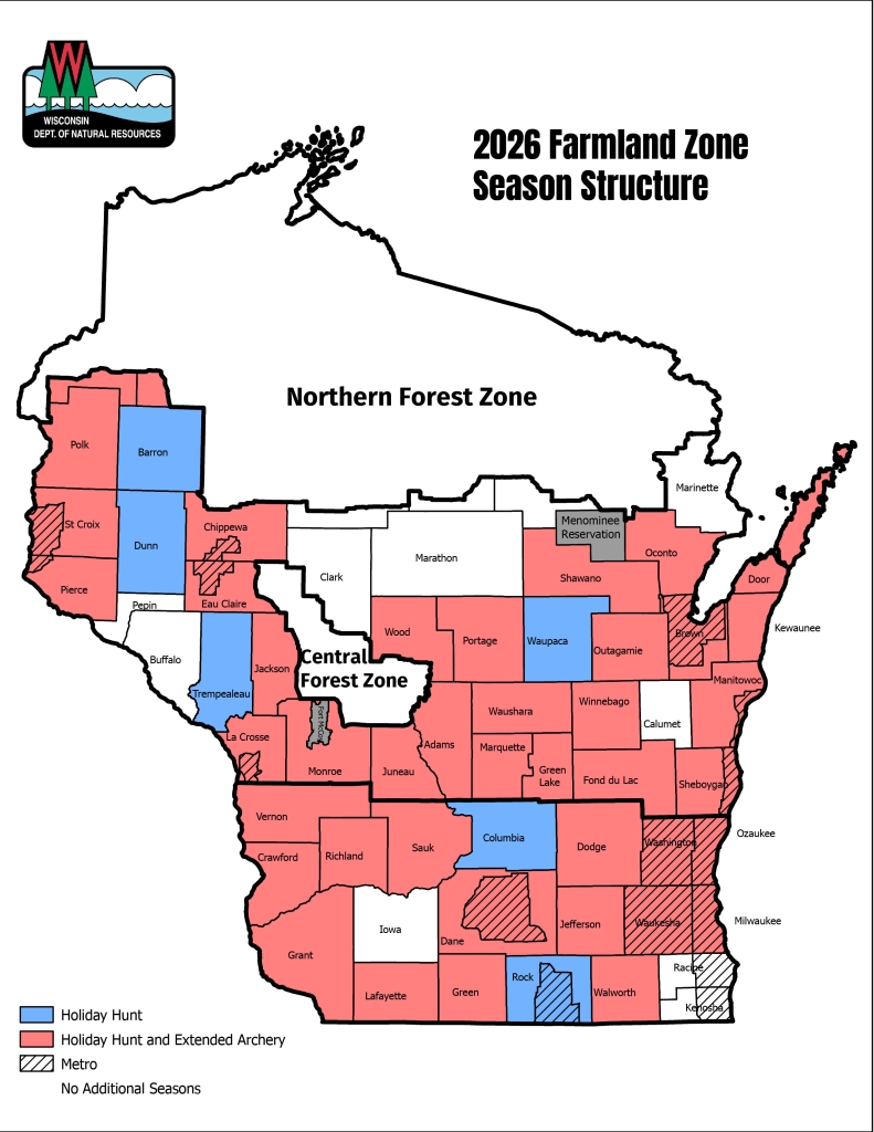
The DNR puts Bayfield County entirely in its Northern Forest Zone. DNR quota math for 2026 puts 5,415 antlerless deer on these units.
| Deer unit | Zone | Quota | Bonus offered (public / private) | Left on Oct 19 | Tags with license |
|---|---|---|---|---|---|
| DMU 103 | Northern Forest | 470 | 450 / 1,600 | 55 / 1,425 | – |
| DMU 102 | Northern Forest | 925 | 1,350 / 2,500 | 404 / 1,718 | – |
| DMU 113 | Northern Forest | 1,155 | 1,900 / 2,750 | 1,369 / 2,244 | – |
| DMU 106 | Northern Forest | 710 | 650 / 2,300 | 521 / 2,092 | – |
| DMU 107 | Northern Forest | 2,155 | 5,650 / 3,400 | 4,503 / 2,891 | – |
Baiting is still allowed in Bayfield County, capped at 2 gallons per site. The county’s wild deer have been sampled 2,155 times for CWD; 0 came back positive. Last CWD year (2025) the county sent in 84 samples, 0 positive.
Because the units were redrawn in 2025, only that year exists: DMU 103 1,134, DMU 102 2,184 and DMU 113 1,776. So far in 2026 (preliminary, early seasons only): DMU 103 50, DMU 102 184 and DMU 113 140.
Units and zones from counties.json and the DNR 2026 antlerless quota and permit table; bonus counts listed on the DNR bonus availability page on October 19; Holiday Hunt and extended archery from the DNR 2026 map; CWD from the DNR CWD county summary; baiting from the DNR baiting page; harvest from DNR Deer Metrics and the preliminary 2026 harvest page. Checked October 19, 2026.
Wildlife offices closest to Iron River
Walk-in help for Iron River hunters comes from the DNR service center listed first; the others handle their own properties.
DNR Spooner Service Center, 58 mi southwest
David R. Obey Northern Great Lakes Visitor Center, 21 mi east
DNR Ashland Field Office, 23 mi east
From the DNR office locations and field locations pages and the federal office pages listed in services.json, checked October 19, 2026.
Venison, mounts and gear near Iron River
Phone, map and website buttons appear where the source listed them. Hours were not checked. Hursh Meat Processing (18 mi) is on the DNR list of places to donate deer. CWD samples can be dropped at Timberghost Taxidermy.
| Service | Close (15 mi) | Wider (35 mi) | Closest | City |
|---|---|---|---|---|
| Deer processors | 0 | 2 | Hursh Meat Processing 18 mi west | Poplar |
| Taxidermy shops | 3 | 9 | Timberghost Taxidermy 1.0 mi south | Iron River |
| Sporting goods | 2 | 19 | G W & C Guns 1.1 mi south | Iron River |
Deer processors
Taxidermy shops
Sporting goods
Processors from the DNR deer donation list, DNR CWD sampling stations and Yellow Pages; shops from the DNR license sales locations (license-only agents left out) and Yellow Pages; guides and preserves from Yellow Pages. Checked October 19, 2026; hours were not checked.
Open and upcoming seasons at Iron River
From bear baiting in September to the last spring turkey period, 39 season segments apply to Iron River.
| Species | Hunt type | Zone or unit | Opening | Closing | Now |
|---|---|---|---|---|---|
| White-tailed deer | Archery and crossbow | Statewide | Sep 12, 2026 | Jan 3, 2027 | |
| White-tailed deer | Youth and disabled gun deer hunt | Statewide | Oct 10, 2026 | Oct 11, 2026 | |
| White-tailed deer | Gun deer (9-day) | Statewide | Nov 21, 2026 | Nov 29, 2026 | |
| White-tailed deer | Muzzleloader | Statewide | Nov 30, 2026 | Dec 9, 2026 | |
| White-tailed deer | Statewide antlerless-only (December 4-day hunt) | Statewide | Dec 10, 2026 | Dec 13, 2026 | |
| Black bear | Bear (Class A license by drawing) | Bear Zone A | Sep 9, 2026 | Sep 15, 2026 | |
| Black bear | Bear (Class A license by drawing) | Bear Zone A | Sep 16, 2026 | Oct 6, 2026 | |
| Black bear | Bear (Class A license by drawing) | Bear Zone A | Oct 7, 2026 | Oct 13, 2026 | |
| Elk | Elk (archery, crossbow and firearm) | Northern Elk Zone | Oct 17, 2026 | Dec 13, 2026 | |
| Wild turkey | Fall turkey | Turkey Zone 6 | Sep 12, 2026 | Jan 3, 2027 | |
| Wild turkey | Spring youth turkey hunt | Turkey Zone 6 | Apr 17, 2027 | Apr 18, 2027 | |
| Wild turkey | Spring turkey Period A | Turkey Zone 6 | Apr 21, 2027 | Apr 27, 2027 | |
| Wild turkey | Spring turkey Period B | Turkey Zone 6 | Apr 28, 2027 | May 4, 2027 | |
| Wild turkey | Spring turkey Period C | Turkey Zone 6 | May 5, 2027 | May 11, 2027 | |
| Wild turkey | Spring turkey Period D | Turkey Zone 6 | May 12, 2027 | May 18, 2027 | |
| Wild turkey | Spring turkey Period E | Turkey Zone 6 | May 19, 2027 | May 25, 2027 | |
| Wild turkey | Spring turkey Period F | Turkey Zone 6 | May 26, 2027 | Jun 1, 2027 | |
| Ruffed Grouse | Ruffed grouse | Grouse Zone A | Sep 12, 2026 | Jan 3, 2027 | |
| Pheasant | Pheasant | Statewide | Oct 17, 2026 | Jan 3, 2027 | |
| Bobwhite Quail | Bobwhite quail | Statewide | Oct 17, 2026 | Dec 9, 2026 | |
| Hungarian partridge | Hungarian partridge | Statewide | Oct 17, 2026 | Jan 3, 2027 | |
| Squirrel | Squirrel | Statewide | Sep 12, 2026 | Feb 28, 2027 | |
| Cottontail | Cottontail rabbit | Northern cottontail zone | Sep 12, 2026 | Feb 28, 2027 | |
| Snowshoe Hare | Snowshoe hare | Statewide | Year-round | Year-round | Year-round |
| American Crow | Crow | Statewide | Nov 21, 2026 | Mar 24, 2027 | |
| Ducks | Youth waterfowl hunt | Statewide | Sep 19, 2026 | Sep 20, 2026 | |
| Ducks | Regular duck | Northern Duck Zone | Sep 26, 2026 | Nov 24, 2026 | |
| Teal | Early teal | Statewide | Sep 1, 2026 | Sep 9, 2026 | |
| Geese | Regular goose | Northern Goose Zone | Sep 16, 2026 | Dec 16, 2026 | |
| Canada goose | Early Canada goose | Statewide | Sep 1, 2026 | Sep 15, 2026 | |
| Raccoon | Raccoon (resident) | Statewide | Oct 17, 2026 | Feb 15, 2027 | |
| Raccoon | Raccoon (nonresident) | Statewide | Oct 31, 2026 | Feb 15, 2027 | |
| Red and gray fox | Fox (red and gray) | Statewide | Oct 17, 2026 | Feb 15, 2027 | |
| Coyote | Coyote (hunting) | Statewide | Year-round | Year-round | Year-round |
| Bobcat | Bobcat Period 1 (hunting and trapping) | Northern Zone (State Hwy. 64 line) | Oct 17, 2026 | Dec 25, 2026 | |
| Bobcat | Bobcat Period 1 (hunting and trapping) | Southern Zone (State Hwy. 64 line) | Oct 17, 2026 | Dec 25, 2026 | |
| Bobcat | Bobcat Period 2 (hunting and trapping) | Northern Zone (State Hwy. 64 line) | Dec 26, 2026 | Jan 31, 2027 | |
| Bobcat | Bobcat Period 2 (hunting and trapping) | Southern Zone (State Hwy. 64 line) | Dec 26, 2026 | Jan 31, 2027 | |
| Unprotected species | Unprotected species (opossum, skunk, weasel, woodchuck, porcupine, starling, English sparrow, chukar, coturnix quail, etc.) | Statewide | Year-round | Year-round | Year-round |
From the Wisconsin Department of Natural Resources Fall 2026-Spring 2027 hunting regulations and season dates, checked October 19, 2026.
Iron River gun ranges
The three nearest listed ranges, in straight-line miles from Iron River.
rifle on file
rifle, handgun, archery, trap, shotgun on file
rifle, handgun, trap, skeet, sporting clays on file
Straight-line miles from the town center; ranges checked October 19, 2026.
Iron River shooting time on key dates
Big game and small game hunters get 20 minutes after sunset in Wisconsin, not 30. Waterfowl and spring gobbler hunters quit at sunset.
| When | Event | North | South |
|---|---|---|---|
| Sep 12, 2026 | Archery, fall turkey and grouse opener | 6:11 a.m. to 7:43 p.m. | 6:13 a.m. to 7:42 p.m. |
| Oct 17, 2026 | Pheasant and duck dates | 6:55 a.m. to 6:37 p.m. | 6:54 a.m. to 6:40 p.m. |
| Nov 1, 2026 | Early November | 6:16 a.m. to 5:13 p.m. | 6:13 a.m. to 5:17 p.m. |
| Nov 21, 2026 | Gun deer opener | 6:44 a.m. to 4:50 p.m. | 6:39 a.m. to 4:56 p.m. |
| Dec 1, 2026 | Muzzleloader week | 6:56 a.m. to 4:44 p.m. | 6:51 a.m. to 4:51 p.m. |
| Dec 24, 2026 | Holiday Hunt opener | 7:15 a.m. to 4:46 p.m. | 7:09 a.m. to 4:54 p.m. |
| Jan 3, 2027 | Archery close (most units) | 7:17 a.m. to 4:55 p.m. | 7:11 a.m. to 5:02 p.m. |
Deer, bear, elk, small game and fall turkey table times from the Wisconsin Department of Natural Resources shooting hours tables, plus the Zone E offset of 16 minutes for longitude 91.40 W, checked October 19, 2026. Shooting hours for every county.
Iron River hunting, answered
How late can I hunt deer near Iron River?
On Nov 21, 2026 the DNR tables, with the 16-minute longitude offset, give 6:44 a.m. to 4:50 p.m. in the Northern area and 6:39 a.m. to 4:56 p.m. in the Southern area.
Where can I get a deer cut and wrapped near Iron River?
Our closest processor listing is Hursh Meat Processing in Poplar, 18 miles out. We list 2 within 35 miles.
How many taxidermy listings surround Iron River?
Nearest on our taxidermy list: Timberghost Taxidermy, 1 mile from town. 9 lie within 35 miles.
Who sells hunting licenses near Iron River?
Licenses and tags sell online through Go Wild and at DNR license agents. 6 license agents sit within 15 miles, nearest Midland Services Iron River (1.1 mi). Nearest DNR counter: DNR Spooner Service Center.
How do I register a deer shot near Iron River?
GameReg, online or by phone, by 5 p.m. the next day. For CWD, Timberghost Taxidermy is a sampling station.
How do I get an elk tag near Iron River?
The county touches the Northern Elk Management Zone. Apply for the elk drawing. It runs: Oct 17 to Dec 13, 2026.
Which property do you reach first from Iron River?
Measured from the town point: Bayfield County Forest, whose boundary is under a mile away. Second-nearest is Washburn Ranger District (Chequamegon-Nicolet National Forest), also worth a look.
Does Iron River have a lot of public acreage nearby?
105,729 acres of state, county and federal land fall within 10 miles. 9 listed lands make up the total.
Which deer management unit covers Iron River?
DMU 103 is the main unit here. 470 antlerless deer is the 2026 goal.
Do bonus tags sell out around Iron River?
DMU 103 started with 450 public and 1,600 private bonus authorizations. Remaining October 19: 1,425 private, 55 public. Go Wild sells them one per person per day.
Has CWD turned up near Iron River?
Bayfield County has had 0 CWD-positive wild deer since 1999. It is one of 12 counties with legal baiting.
How many points does it take to draw a bear tag near Iron River?
Iron River sits in Bear Zone A. Applicants needed 11 points for Zone A in 2026. Bayfield County registered 185 bears in 2025.
Answers drawn from the sources listed in each section above, checked October 19, 2026.
Out the door in Iron River
Heading out of Iron River? Check the shooting-hours table for your area and the season table for Bayfield County.
Other photos on this page: royal_broil (CC BY-SA 2.0); Anne Marie Peterson from Madison, WI, US (CC BY-SA 2.0); Doc Searls from Santa Barbara, USA (CC BY 2.0); USFWS Midwest Region (Public Domain Mark 1.0); Juliana Chong (CC BY 2.0); Olivier Bruchez (CC BY-SA 2.0); Rodney Campbell (CC BY 2.0); Greg Gilbert (CC BY 2.0).