Home › Oklahoma › Towns › Beaver
Beaver County, Oklahoma
Hunting land and seasons near Beaver, OK
Public hunting land measured from Beaver, the antlerless deer zone and elk zone of Beaver County, controlled hunts within reach, legal light and the processors and shops nearby.
Photo: Small lake ringed by golden grass below sand hills at Beaver Dunes, Beaver County; elsewhere in Beaver County, a nearby stand-in. Leaflet (CC0 1.0)
Beaver is the county seat of Beaver County, which ODWC places in its Northwest Region. This page is here for Beaver River Wildlife Management Area, whose edge is within 1 mile of Beaver. About 1,252 people lived in Beaver by the 2024 Census estimate. 8 listed areas sit within 10 miles of Beaver: about 18,605 mapped public acres plus 2,060 acres of OLAP walk-in land. Within 25 miles the map holds 16 listed areas, roughly 28,533 public acres in all. ODWC, federal and Corps polygons cover about 28,533 acres of Beaver County, with 28,533 acres of ODWC area land among them. The straight line from Beaver meets Beaver River WMA, with its closest edge 1.0 miles out first.
Town point and land area from the Census 2024 Gazetteer, population from the Census Vintage 2024 estimates; public acreage and boundary miles within 10 and 25 miles are a GIS measure over the ODWC WMA layer and USFS, USFWS, Corps and NPS boundaries (places.json; area counts are within 25 miles); OLAP tract acres from the ODWC OLAP layer. ODWC region from the ODWC administrative boundaries layer. Checked November 3, 2026.
Nearby
Places to hunt and shoot around Beaver
Public hunting land from Beaver, nearest first
Rows run by nearest boundary, then by mapped-point miles; each land page carries the special regulations, contacts and zones.
| Name | How far | Land type | Manager | What it takes | Size (ac) | Notes |
|---|---|---|---|---|---|---|
| Beaver River WMA core area | 1.0 mi W | WMA | ODWC | Area rules | 18,624 | Layer acres differ |
| Beaver River WMA – McFarland Unit | 1.0 mi NW | WMA unit | ODWC | Area rules | 5,110 | Nonresident check-in |
| Beaver County OLAP walk-in H018 | 4.9 mi N | OLAP walk-in | ODWC lease | Land Access Permit | 160 | CRP Grassland |
| Beaver County OLAP walk-in H050 | 5.7 mi W | OLAP walk-in | ODWC lease | Land Access Permit | 640 | CRP grassland. Verifie |
| Beaver County OLAP walk-in H051 | 5.9 mi NW | OLAP walk-in | ODWC lease | Land Access Permit | 160 | CRP grassland |
| Beaver County OLAP walk-in H025 | 6.6 mi N | OLAP walk-in | ODWC lease | Land Access Permit | 160 | CRP Grassland |
| Beaver County OLAP walk-in H029 | 7.3 mi NW | OLAP walk-in | ODWC lease | Land Access Permit | 460 | CRP Grassland |
| Beaver County OLAP walk-in H022 | 9.0 mi NW | OLAP walk-in | ODWC lease | Land Access Permit | 480 | CRP Grassland |
| Beaver County OLAP walk-in H030 | 10 mi NW | OLAP walk-in | ODWC lease | Land Access Permit | 640 | CRP Grassland |
| Beaver County OLAP walk-in H057 | 11 mi W | OLAP walk-in | ODWC lease | Land Access Permit | 1,920 | Native prairie grassla |
| Beaver County OLAP walk-in H021 | 15 mi NW | OLAP walk-in | ODWC lease | Land Access Permit | 160 | CRP grassland and WRP |
| Beaver County OLAP walk-in H061 | 15 mi W | OLAP walk-in | ODWC lease | Land Access Permit | 800 | CRP Grassland |
| Beaver County OLAP walk-in H060 | 18 mi SW | OLAP walk-in | ODWC lease | Land Access Permit | 1,130 | Native short grass pra |
| Lake Evans Chambers (Dept. lake) | 18 mi E | Department lake | ODWC | Sept 1 to spring turkey | 204 | Nonresident check-in |
By size, Beaver River WMA (18,624 acres) leads the list near Beaver. The ODWC page says 18,624 acres, while the WMA GIS layer shows 28,069; this page prints the page figure. Within 25 miles there are 2 ODWC-managed areas, 13 OLAP tracts and 1 lake or park area. On Beaver River WMA – McFarland Unit, ODWC allows camping for up to 16 straight days, keeps vehicles to open roads and limits target shooting to designated ranges. Its hunting line is (806) 339-5175. Nonresidents must check in before hunting Beaver River WMA – McFarland Unit. 11 OLAP walk-in or limited access tracts sit within reach; Beaver County OLAP walk-in H018 comes first.
Six nearest areas from Beaver
- Beaver River WMA: 18,624 acres; acres for non-ambulatory permits 2,352; open for deer, dove, turkey, rabbit, squirrel; deer harvest 2025: 26; five designated primitive camping areas are offered on the area (printable map)
- Beaver River WMA – McFarland Unit: 5,110 acres; seasons for dove, turkey, deer, rabbit, squirrel; five designated primitive camping areas are offered on the area (map PDF)
- Beaver County OLAP walk-in H018: 160 acres; open for deer, quail, pheasant, dove, rabbit; habitat: CRP Grassland
- Beaver County OLAP walk-in H050: 640 acres; seasons for deer, quail, pheasant, dove, rabbit; tract cover: CRP grassland. Verified 8/26/2020
- Beaver County OLAP walk-in H051: 160 acres; hunted for deer, quail, pheasant, dove, rabbit; habitat: CRP grassland
- Beaver County OLAP walk-in H025: 160 acres; seasons for deer, quail, pheasant, dove, rabbit; cover: CRP Grassland
Lands from ODWC area pages, Public Hunting Areas special regulations and the OLAP layer, USFWS, USFS, NPS, Corps and installation records (lands.json; each land page cites its own source); 2025 deer harvest by area from the ODWC 2025-26 big game harvest report. Boundary miles from places.json, other miles to each mapped point. Area rules from the Department-Managed Area Rules. Checked November 3, 2026.
ODWC harvest counts for Beaver
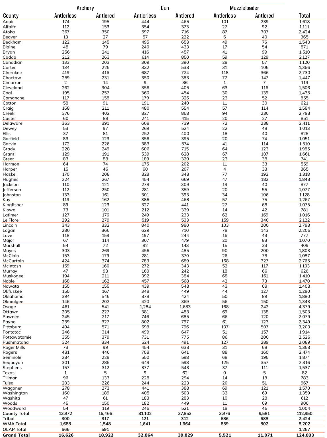
The 2025 county deer harvest for Beaver County came to 388, private and non-WMA land only. That is down 8% from 421 in 2024. Rifles and shotguns: 313; archery: 57. The busiest nearby area for deer in 2025 was Beaver River WMA: 26 checked. Beaver County also reported 1 elk and 79 mule deer in 2025. County turkey harvest is not published; statewide spring 2025 came to an estimated 11,232.
| Year | Checked | Rifle etc. | ML | Archery | Antlered |
|---|---|---|---|---|---|
| 2021-22 | 403 | 332 | 29 | 42 | 318 |
| 2022-23 | 432 | 349 | 25 | 58 | 321 |
| 2023-24 | 365 | 279 | 46 | 40 | 289 |
| 2024-25 | 421 | 346 | 29 | 46 | 305 |
| 2025-26 | 388 | 313 | 18 | 57 | 284 |
| Nearby area | 2024 | 2025 |
|---|---|---|
| Beaver River WMA | 28 | 26 |
County deer harvest from the ODWC big game reports (2021, 2022, 2023, 2024, 2025); area harvest and 2025 elk, bear, mule deer and pronghorn from the 2025-26 big game harvest report; turkey from the ODWC Game Harvest Survey. Checked November 3, 2026.
What changes at the county line near Beaver
Deer dates are the same statewide; what changes from county to county around Beaver is how many does you may take and which other seasons are open.
| County | Doe zone | Antlerless limit | Elk | Fall turkey gun | Other |
|---|---|---|---|---|---|
| Beaver County this county | 2, 1 | 4/4; 0/1 | Panhandle | Open | Pheasant, Crane, jackrabbit, Panhandle ducks |
| Texas County | 1 | 0/1 | Panhandle | Open | Pronghorn, Pheasant, Crane, jackrabbit, CWD SSA, Panhandle ducks |
The ODWC map divides Beaver County among antlerless zones (Zone 2 about 89%, Zone 1 about 11%); check which side of the boundary road you hunt. (Zone 2, Zone 1; antlerless deer zone map.) The zone sets the doe count: Zone 2: 4 antlerless by muzzleloader and 4 by gun; Zone 1: no antlerless deer by muzzleloader and one by gun. The six-deer combined limit (two antlered) leaves holiday antlerless and controlled-hunt deer outside the count. Youth gun days fall on October 16 to October 18, before the muzzleloader opener on October 24. Beaver County lies in the Panhandle Zone for elk, open on private land with written landowner permission (a zone quota of 80 in the Panhandle Zone). (Panhandle Zone.) Beaver County keeps a fall gun turkey season this year, October 31 to November 20. ODWC lists Beaver County among the 13 full pheasant counties. Panhandle duck dates apply in Beaver County. West of I-35 rules reach Beaver County: cranes and jackrabbits may be hunted. Bait rules: none on ODWC areas, none near turkey hunting, and federal migratory bird baiting rules for ducks and doves.
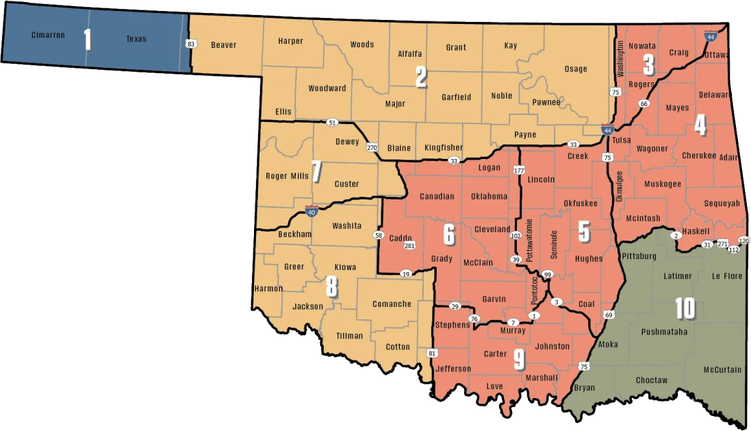
Zones from the ODWC antlerless deer zone map (county shares are a GIS overlay; the legal line is the road), ODWC elk zones, the bear area, fall turkey counties, the pheasant area, waterfowl zones, the crane area and the CWD surveillance areas; limits and baiting from the 2026-2027 Oklahoma Fishing and Hunting Regulations and ODWC turkey regulations. Checked November 3, 2026.
Beaver game processors, taxidermists and shops
Counts run to 15 and 35 miles from Beaver, and the nearest few businesses of each trade follow below. For gear, the first store listed is Mac B's Gun Shop in Laverne. For a fee hunt, J & J Hunting at Arnett is the first listing.
| Kind | 15 mi | 35 mi | Closest listing | Distance | In |
|---|---|---|---|---|---|
| Deer cutting | 0 | 0 | Gage Locker Service | 55 mi SE | Gage |
| Hunting retailers | 0 | 0 | Mac B's Gun Shop | 36 mi E | Laverne |
| Licensed hunting areas | 0 | 0 | J & J Hunting | 63 mi SE | Arnett |
Deer cutting
Hunting retailers
Licensed hunting areas
Processors from the ODWC game processor list (Hunters Against Hunger column) and Yellow Pages; commercial hunting areas from the ODWC commercial hunt area list; taxidermists and shops from Yellow Pages and chain store locators (services.json). Listings without coordinates are placed at their town. Checked November 3, 2026; hours were not checked.
Beaver controlled hunt areas
From Beaver, the closest controlled-hunt ground is Beaver River WMA – McFarland Unit, 1.7 mi out. Missed it? The 2026 controlled hunt deadline was May 20, 2026. Half of elk and pronghorn permits go to applicants with 20 or more preference points, the other half to everyone.
| Area | Miles off | Kind | What was drawn | Permits |
|---|---|---|---|---|
| Beaver River WMA – McFarland Unit | 1.7 mi | WMA unit | Deer, Youth deer | 25 |
| Beaver River WMA | 7.8 mi | WMA | Deer | 22 |
2025 controlled hunt results per area from the ODWC controlled hunts results (lands.json, controlled_hunts_2025); rules and dates from the ODWC controlled hunts page. Checked November 3, 2026.
Seasons open near Beaver
Elk, bear, pronghorn, pheasant and sandhill crane seasons only cover part of the state, so the area column tells you whether a row reaches Beaver County.
| Game | Season | Area | Opens | Closes | Today |
|---|---|---|---|---|---|
| White-tailed deer | Archery | Zone 2, 7, 8 | Oct 1, 2026 | Jan 15, 2027 | |
| White-tailed deer | Youth gun | Zone 2, 7, 8 | Oct 16, 2026 | Oct 18, 2026 | |
| White-tailed deer | Muzzleloader | Zone 2, 7, 8 | Oct 24, 2026 | Nov 1, 2026 | |
| White-tailed deer | Gun | Zone 2, 7, 8 | Nov 21, 2026 | Dec 6, 2026 | |
| White-tailed deer | Holiday antlerless | Zone 2, 7, 8 | Dec 18, 2026 | Dec 31, 2026 | |
| Mule deer | All deer seasons | Statewide | Oct 1, 2026 | Jan 15, 2027 | |
| Elk | Archery | Panhandle elk zone | Oct 1, 2026 | Jan 15, 2027 | |
| Elk | Youth elk gun | Panhandle elk zone | Oct 16, 2026 | Oct 18, 2026 | |
| Elk | Muzzleloader | Panhandle elk zone | Oct 24, 2026 | Nov 1, 2026 | |
| Elk | Gun | Panhandle elk zone | Nov 21, 2026 | Dec 6, 2026 | |
| Elk | Holiday antlerless elk | Panhandle elk zone | Dec 18, 2026 | Dec 31, 2026 | |
| Wild turkey | Youth fall turkey | Open counties | Oct 16, 2026 | Oct 18, 2026 | |
| Wild turkey | Fall Gun | Open counties | Oct 31, 2026 | Nov 20, 2026 | |
| Wild turkey | Fall Archery | Statewide | Oct 1, 2026 | Jan 15, 2027 | |
| Wild turkey | Youth Spring | Statewide | Apr 10, 2027 | Apr 11, 2027 | |
| Wild turkey | Spring | Statewide | Apr 16, 2027 | May 16, 2027 | |
| Feral hogs | Private land | Private land | Jul 1, 2026 | Jun 30, 2027 | |
| Quail | Season | Statewide | Nov 14, 2026 | Feb 15, 2027 | |
| Pheasant | Season | Pheasant counties | Dec 1, 2026 | Jan 31, 2027 | |
| Rabbits | Season | Statewide | Oct 1, 2026 | Mar 15, 2027 | |
| Jackrabbit | Season | West of I-35 | Oct 1, 2026 | Mar 15, 2027 | |
| Squirrels | Season | Statewide | May 15, 2026 | Feb 28, 2027 | |
| Doves | Segment 1 | Statewide | Sep 1, 2026 | Oct 31, 2026 | |
| Doves | Segment 2 | Statewide | Dec 1, 2026 | Dec 29, 2026 | |
| Teal | September Teal | Statewide | Sep 12, 2026 | Sep 20, 2026 | |
| Ducks | Youth and veteran day | Panhandle | Oct 3, 2026 | Oct 3, 2026 | |
| Ducks | Regular | Panhandle | Oct 10, 2026 | Jan 13, 2027 | |
| Ducks | Youth and veteran day | Panhandle | Jan 30, 2027 | Jan 30, 2027 | |
| Canada geese | September Canada goose | Statewide | Sep 12, 2026 | Sep 21, 2026 | |
| Dark geese | Segment 1 | Statewide | Nov 7, 2026 | Dec 6, 2026 | |
| Dark geese | Segment 2 | Statewide | Dec 12, 2026 | Feb 14, 2027 | |
| Specklebellies | Segment 1 | Statewide | Nov 7, 2026 | Dec 6, 2026 | |
| Specklebellies | Segment 2 | Statewide | Dec 12, 2026 | Feb 7, 2027 | |
| Light geese | Segment 1 | Statewide | Nov 7, 2026 | Dec 6, 2026 | |
| Light geese | Segment 2 | Statewide | Dec 12, 2026 | Feb 14, 2027 | |
| Light geese | Conservation order | Statewide | Feb 15, 2027 | Mar 30, 2027 | |
| Sandhill crane | Season | West of I-35 | Oct 17, 2026 | Jan 17, 2027 | |
| Woodcock | Season | Statewide | Nov 7, 2026 | Dec 21, 2026 | |
| Coyote | Year-round | Statewide | Jul 1, 2026 | Jun 30, 2027 | |
| Bobcat | Furbearer season | Statewide | Dec 1, 2026 | Feb 28, 2027 | |
| Gray fox | Furbearer season | Statewide | Dec 1, 2026 | Feb 28, 2027 | |
| Red fox | Furbearer season | Statewide | Dec 1, 2026 | Feb 28, 2027 | |
| Raccoon | Year-round | Statewide | Jul 1, 2026 | Jun 30, 2027 | |
| Prairie dog | Year-round | Statewide | Jul 1, 2026 | Jun 30, 2027 | |
| Beaver | Year-round | Statewide | Jul 1, 2026 | Jun 30, 2027 | |
| Nutria | Year-round | Statewide | Jul 1, 2026 | Jun 30, 2027 | |
| Striped skunk | Year-round | Statewide | Jul 1, 2026 | Jun 30, 2027 | |
| Bullfrogs | Year-round | Statewide | Jul 1, 2026 | Jun 30, 2027 | |
| Rails | Season | Statewide | Sep 1, 2026 | Nov 9, 2026 | |
| Gallinules | Season | Statewide | Sep 1, 2026 | Nov 9, 2026 | |
| Snipe | Season | Statewide | Sep 26, 2026 | Jan 10, 2027 | |
| Crows | Segment 1 | Statewide | Oct 10, 2026 | Nov 16, 2026 | |
| River otter | Furbearer season | Statewide | Dec 1, 2026 | Feb 28, 2027 | |
| Badger | Furbearer season | Statewide | Dec 1, 2026 | Feb 28, 2027 | |
| Mink | Furbearer season | Statewide | Dec 1, 2026 | Feb 28, 2027 | |
| Muskrat | Furbearer season | Statewide | Dec 1, 2026 | Feb 28, 2027 | |
| Opossum | Furbearer season | Statewide | Dec 1, 2026 | Feb 28, 2027 | |
| Weasel | Furbearer season | Statewide | Dec 1, 2026 | Feb 28, 2027 | |
| Crows | Segment 2 | Statewide | Dec 9, 2026 | Mar 4, 2027 | |
| Rattlesnakes | Season | Statewide | Mar 1, 2027 | Jun 30, 2027 |
From the ODWC hunting regulations and the 2026-2027 Oklahoma Fishing and Hunting Regulations (Oklahoma Department of Wildlife Conservation), checked November 3, 2026.
Dates a short trip from Beaver
The 30-mile radius around Beaver catches 1 upcoming listing; the kinds are ODWC controlled hunt. Entry to the 1 controlled hunt came through the spring draw on Go Outdoors Oklahoma.
Coming up
| Dates | Event | How far | Where | Button | Source |
|---|---|---|---|---|---|
| Nov 21–22, 2026 | Beaver River WMA deer controlled hunt | 8 | Event details | Source |
Beaver hunters: clubs and WMA benches close by
Every card gives the access rule for Beaver shooters.
Straight-line miles from the town centre; ranges checked November 3, 2026.
Beaver: ODWC office, supervisor and wardens
ODWC Headquarters, 1801 N. Lincoln Blvd., Oklahoma City, is the nearest ODWC office. Beaver County is in the ODWC Northwest Region, whose wildlife supervisor is Scott Parry, phone (580) 334-3345. Ben Bickerstaff captains the game wardens of District 8, Beaver County among them. The Beaver County warden phones on ODWC area pages are (405) 568-0366. On the Wildlife Conservation Commission map, Beaver County is District 8.
ODWC office, Oklahoma City
Lawton: ODWC Lawton Office & J.A. Manning State Fish Hatchery
Offices from the ODWC offices list, game warden districts and captains from the ODWC game warden directory, region supervisors from the ODWC administrative boundaries layer, county warden phones from ODWC area pages (counties.json, services.json, lands.json). Offices without a geocoded address are measured to their town. Checked November 3, 2026.
Beaver legal shooting light
Quail and pheasant hours are sunrise to sunset, shorter than the big game window, and OLAP walk-in land closes to them at 4:30 p.m.
| Date | Season point | Sunrise | Sunset | Big game | Waterfowl | Quail |
|---|---|---|---|---|---|---|
| Oct 1, 2026 | Archery deer opens | 7:36 a.m. | 7:27 p.m. | 7:06 a.m.–7:57 p.m. | 7:06 a.m.–7:27 p.m. | 7:36 a.m.–7:27 p.m. |
| Oct 24, 2026 | Muzzleloader opens | 7:57 a.m. | 6:55 p.m. | 7:27 a.m.–7:25 p.m. | 7:27 a.m.–6:55 p.m. | 7:57 a.m.–6:55 p.m. |
| Nov 21, 2026 | Gun deer opens | 7:26 a.m. | 5:30 p.m. | 6:56 a.m.–6:00 p.m. | 6:56 a.m.–5:30 p.m. | 7:26 a.m.–5:30 p.m. |
| Dec 6, 2026 | Gun deer closes | 7:40 a.m. | 5:26 p.m. | 7:10 a.m.–5:56 p.m. | 7:10 a.m.–5:26 p.m. | 7:40 a.m.–5:26 p.m. |
| Dec 21, 2026 | Shortest day | 7:50 a.m. | 5:29 p.m. | 7:20 a.m.–5:59 p.m. | 7:20 a.m.–5:29 p.m. | 7:50 a.m.–5:29 p.m. |
| Jan 15, 2027 | Archery closes | 7:54 a.m. | 5:48 p.m. | 7:24 a.m.–6:18 p.m. | 7:24 a.m.–5:48 p.m. | 7:54 a.m.–5:48 p.m. |
| Apr 16, 2027 | Spring turkey | 7:08 a.m. | 8:16 p.m. | 6:38 a.m.–8:46 p.m. | 6:38 a.m.–8:16 p.m. | 7:08 a.m.–8:16 p.m. |
Hours rules from the ODWC big game regulations and the 2026-2027 Oklahoma Fishing and Hunting Regulations; sunrise and sunset worked out for this location with the NOAA solar formula (Central Time); checked November 3, 2026. Legal hours for every county.
Asked about Beaver
What evidence of sex must stay on an Oklahoma deer?
It stays naturally attached until the animal is reported; quartered deer keep the head and sex organs.
Is hunting deer over bait legal on private land in Beaver County?
The regulations read found no statewide private-land deer bait ban; check any lease rules.
Are Oklahoma seasons open seven days a week?
Yes, seasons run every day of the week.
What is OLAP, and is there any near Beaver?
The Oklahoma Land Access Program leases private land for walk-in hunting; 11 tracts lie within reach, the nearest Beaver County OLAP walk-in H018.
Where is the nearest game processor to Beaver?
Gage Locker Service, Gage, about 55 mi from Beaver.
Which ODWC law enforcement district includes Beaver?
District 8, under Captain Ben Bickerstaff.
What are the closest town pages to Beaver?
Forgan, Adams, Buffalo and Guymon, nearest first.
Driving out of Beaver, what is the first public hunting area I come to?
By straight line it is Beaver River WMA, with its closest edge 1.0 miles out. The runner-up by distance is Beaver River WMA – McFarland Unit, with its closest edge 1.0 miles out.
How many listed hunting areas lie within 10 miles of Beaver?
8 areas inside 10 miles, 16 areas inside 25.
Does an antlerless zone line cross Beaver County?
Yes. The GIS overlay shows Zone 2 and Zone 1 in Beaver County.
What date does rifle season for deer open around Beaver?
November 21, 2026.
What are the elk rules for Beaver County?
Private land with written permission in the Panhandle Zone, E-Check within 24 hours, and check the quota first.
Do archers near Beaver need orange during gun season?
Yes, an orange head covering or outer garment above the waist during any open firearm season for big game.
Answers from places.json, lands.json, counties.json, services.json and the 2026-2027 Oklahoma Fishing and Hunting Regulations; reporting from ODWC, hunter orange from the ODWC big game regulations, baiting from ODWC, Sunday hunting from ODWC seasons, the Land Access Permit from the ODWC license fees, CWD from ODWC. Checked November 3, 2026.
Beaver trip checklist
Before leaving Beaver, confirm the county and antlerless zone of the land you picked and whether it needs a Land Access Permit or a check-in.
Other photos on this page: Billy Hathorn (CC BY-SA 3.0); Kool Cats Photography (CC BY 2.0); Lane Pearman (CC BY 2.0); U.S. Fish & Wildlife Service Southwest Region (Public Domain Mark 1.0); Thesagemarmot (CC BY-SA 3.0); Thomas Shahan (CC BY 2.0); Shiva Shenoy (CC BY 4.0); Thomas & Dianne Jones (CC BY 2.0).