All 64 Louisiana parishes, 2026-27
Louisiana Hunting by Parish
Every Louisiana parish with its LDWF field office, Deer Areas from the 2026-27 pamphlet, Turkey Area or closed, Bear Area, duck and dove zones, CWD Management Zone status, alligator lottery zone, LDWF deer harvest rank and mapped public acres. Filter the table by parish, area or office.
Photo: jc.winkler (CC BY 2.0)
Louisiana parishes side by side
Deer seasons in Louisiana are set by ten Deer Areas; 25 parishes are split between two or more of them. Sixteen parishes are closed to turkey hunting, and every parish sits in one of seven Bear Areas, where bears may be taken only by lottery permit. LDWF prints deer harvest only for the top 20 parishes, so most rows show no rank.
| Parish | Field office | Deer Areas | Turkey | Bear | Ducks | Doves | CWD zone | Gator | Deer rank 24-25 | Public acres |
|---|---|---|---|---|---|---|---|---|---|---|
| Acadia | Lake Charles | 3/10 | Closed | 1 | West | North and South | — | E | — | 0 |
| Allen | Lake Charles | 3/2 | A | 1/6 | West | North and South | — | E | — | 60,962 |
| Ascension | Hammond | 9 | C | 1/7 | East | South | — | G | — | 19,214 |
| Assumption | Lafayette | 9 | Closed | 1 | East | South | — | F | — | 2,815 |
| Avoyelles | Lafayette | 6/2 | C | 3 | East | North | Part | C | #17 | 51,115 |
| Beauregard | Lake Charles | 3/8 | A | 6 | West | North and South | — | E | #18 | 0 |
| Bienville | Minden | 2 | A | 6 | West and East | North | — | A | #3 | 47 |
| Bossier | Minden | 2 | A | 6 | West | North | — | A | #7 | 33,058 |
| Caddo | Minden | 2 | B | 6 | West | North | — | A | — | 7,773 |
| Calcasieu | Lake Charles | 10/8/3 | A | 1/6 | West | North and South | — | E | — | 8,597 |
| Caldwell | Monroe | 2 | A/C | 5 | East | North | Part | B | — | 45,255 |
| Cameron | Lake Charles | 10 | Closed | 1 | West | South | — | E | — | 168,893 |
| Catahoula | Pineville | 1/2 | A/C | 3/4 | East | North | Part | C | #11 | 48,248 |
| Claiborne | Minden | 2 | A | 6 | West and East | North | — | A | #4 | 18,490 |
| Concordia | Lafayette | 1 | C | 3 | East | North | Part | C | — | 85,188 |
| De Soto | Minden | 2 | B | 6 | West | North | — | A | — | 2,624 |
| East Baton Rouge | Hammond | 4/6 | A | 7 | East | North and South | — | G | — | 0 |
| East Carroll | Monroe | 1 | A/C | 4 | East | North | — | B | — | 7,224 |
| East Feliciana | Hammond | 4/6 | A | 7 | East | North | — | G | — | 0 |
| Evangeline | Lake Charles | 2/6 | A | 6 | West and East | North and South | — | E | — | 988 |
| Franklin | Monroe | 1 | C | 4 | East | North | Part | B | — | 6,682 |
| Grant | Pineville | 2/1 | A | 6 | West and East | North | — | C | #15 | 153,470 |
| Iberia | Lafayette | 7/9/5/10 | C | 1 | West and East | South | — | D | — | 3,591 |
| Iberville | Lafayette | 9/6/5 | C | 1/2/7 | East | South | — | D | — | 18,523 |
| Jackson | Minden | 2 | A | 6 | West and East | North | Part | B | #8 | 0 |
| Jefferson | Hammond | 9 | Closed | 1/7 | West and East | South | — | H | — | 17,382 |
| Jefferson Davis | Lake Charles | 3/10/2 | A | 1/6 | West | North and South | — | E | — | 13 |
| LaSalle | Pineville | 2/1 | A | 3 | East | North | Part | C | #16 | 58,678 |
| Lafayette | Lafayette | 10/3/6/9 | Closed | 1 | West and East | South | — | D | — | 0 |
| Lafourche | Hammond | 9 | Closed | 1 | West and East | South | — | F | — | 24,288 |
| Lincoln | Minden | 2 | A | 6 | East | North | Part | B | #19 | 0 |
| Livingston | Hammond | 9/4 | A | 7 | East | North and South | — | G | — | 29,943 |
| Madison | Monroe | 1 | A/C | 4 | East | North | Part | B | — | 65,937 |
| Morehouse | Monroe | 1/2 | A | 5 | East | North | — | B | — | 31,331 |
| Natchitoches | Pineville | 2 | A | 6 | West | North | — | C | #6 | 146,757 |
| Orleans | Hammond | 9 | Closed | 1/7 | West and East | South | — | H | — | 26,481 |
| Ouachita | Monroe | 2/1 | A | 5 | East | North | Part | B | #14 | 43,340 |
| Plaquemines | Hammond | 9 | Closed | 1/7 | West | South | — | H | — | 62,813 |
| Pointe Coupee | Lafayette | 6 | C | 2 | East | North and South | — | D | — | 9,259 |
| Rapides | Pineville | 2/1/6/3 | A | 6 | West and East | North | — | C | #9 | 120,786 |
| Red River | Minden | 2 | B | 6 | West | North | — | A | — | 5,938 |
| Richland | Monroe | 1 | C | 4/5 | East | North | — | B | — | 3,504 |
| Sabine | Pineville | 2 | A | 6 | West | North | — | C | #13 | 17,690 |
| St. Bernard | Hammond | 9 | Closed | 7 | West | South | — | H | — | 38,751 |
| St. Charles | Hammond | 9 | Closed | 1/7 | West and East | South | — | H | — | 44,776 |
| St. Helena | Hammond | 4 | A | 7 | East | North | — | G | — | 132 |
| St. James | Hammond | 9 | Closed | 1/7 | East | South | — | F | — | 32,487 |
| St. John the Baptist | Hammond | 9 | Closed | 1/7 | East | South | — | H | — | 46,321 |
| St. Landry | Lafayette | 6/3 | C | 2/6 | West and East | North and South | — | D | #20 | 30,619 |
| St. Martin | Lafayette | 5/9/6 | C | 1/2 | East | South | — | D/F | — | 37,414 |
| St. Mary | Lafayette | 7/9/5 | Closed | 1 | West and East | South | — | F | — | 29,952 |
| St. Tammany | Hammond | 4/9 | A | 7 | West and East | North and South | — | H | — | 82,270 |
| Tangipahoa | Hammond | 4/9 | A | 7 | East | North and South | — | G | — | 42,854 |
| Tensas | Monroe | 1 | A/C | 4 | East | North | Part | B | #12 | 37,681 |
| Terrebonne | Lafayette | 9 | Closed | 1 | West and East | South | — | F | — | 15,286 |
| Union | Monroe | 2 | A | 5 | East | North | Part | B | #1 | 36,731 |
| Vermilion | Lake Charles | 10 | Closed | 1 | West | South | — | E | — | 0 |
| Vernon | Lake Charles | 3/2 | A | 6 | West | North | — | C | #2 | 265,032 |
| Washington | Hammond | 4 | A | 7 | East | North | — | G | — | 2,512 |
| Webster | Minden | 2 | A | 6 | West | North | — | A | #10 | 20,055 |
| West Baton Rouge | Lafayette | 6 | C | 1/2 | East | North and South | — | D | — | 0 |
| West Carroll | Monroe | 1 | Closed | 4 | East | North | — | B | — | 938 |
| West Feliciana | Hammond | 6 | A | 2 | East | North | — | G | — | 18,456 |
| Winn | Pineville | 2 | A | 6 | West and East | North | — | C | #5 | 112,238 |
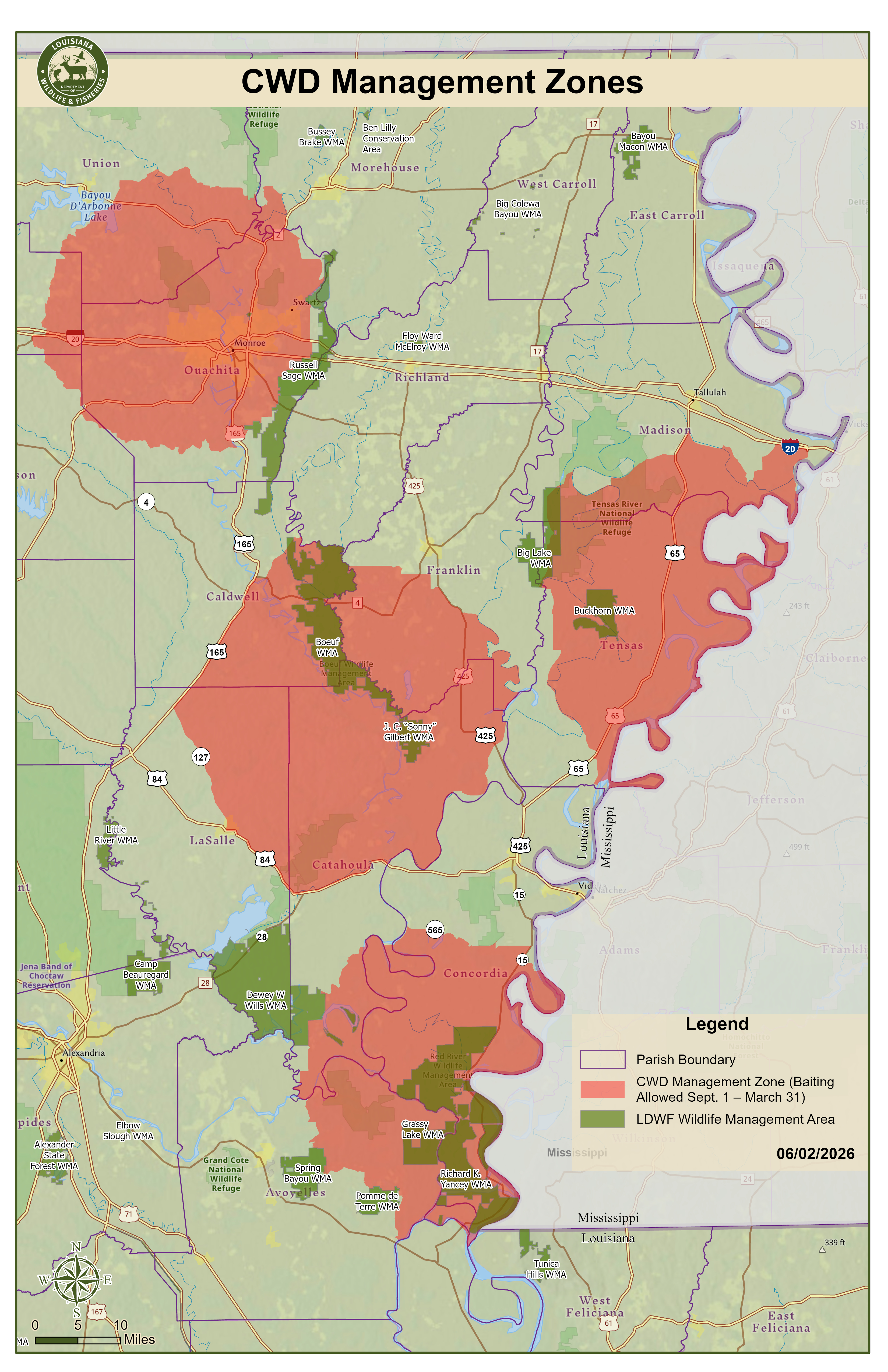
Deer Areas from the 2026-2027 Louisiana Hunting & WMA Regulations; turkey from the turkey pages; bear from the LDWF bear lottery page; ducks from the waterfowl pages; doves from the dove page; CWD from the June 2, 2026 map; alligator zones from the recreational alligator page; deer rank from the 2024-25 deer report; public acres from LDWF, USFS, USFWS and Corps layers. Checked November 4, 2026.
Louisiana parishes by LDWF field office
The LDWF Wildlife Division works from six field offices: Minden, Monroe, Pineville, Lafayette, Lake Charles and Hammond. Each parish page also names its Enforcement Division region and captain and the nearest LDWF office.
LDWF Minden field office area (9)
9 parishes covering the northwest corner: Caddo Lake, the Red River valley, the Kisatchie hills of Claiborne and Webster and the pine and hardwood country around Shreveport. Office: 9961 Hwy 80, Minden ((318) 371-3050). Mapped public land in these parishes comes to about 87,985 acres.
Bienville Parish
Deer 2
Bossier Parish
Deer 2
Caddo Parish
Deer 2
Claiborne Parish
Deer 2
De Soto Parish
Deer 2
Jackson Parish
Deer 2
Lincoln Parish
Deer 2
Red River Parish
Deer 2
Webster Parish
Deer 2
LDWF Monroe field office area (10)
10 parishes covering the northeast: the Ouachita and Boeuf river bottoms, the Mississippi Delta farmland of the Tensas basin and the pine hills around Ruston. Office: 368 Century Link Drive, Monroe ((318) 343-4044). Mapped public land in these parishes comes to about 278,623 acres.
Caldwell Parish
Deer 2
East Carroll Parish
Deer 1
Franklin Parish
Deer 1
Madison Parish
Deer 1
Morehouse Parish
Deer 1/2
Ouachita Parish
Deer 2/1
Richland Parish
Deer 1
Tensas Parish
Deer 1
Union Parish
Deer 2
West Carroll Parish
Deer 1
LDWF Pineville field office area (7)
7 parishes covering central Louisiana: Kisatchie National Forest, the Red River, Catahoula Lake and the longleaf pine hills around Alexandria. Office: 1995 Shreveport Hwy., Pineville ((318) 487-5885). Mapped public land in these parishes comes to about 657,867 acres.
Catahoula Parish
Deer 1/2
Grant Parish
Deer 2/1
LaSalle Parish
Deer 2/1
Natchitoches Parish
Deer 2
Rapides Parish
Deer 2/1/6/3
Sabine Parish
Deer 2
Winn Parish
Deer 2
LDWF Lafayette field office area (12)
12 parishes covering Acadiana and the Atchafalaya Basin: cypress swamp, sugarcane and rice fields, and the bottomland hardwoods along the Mississippi. Office: 200 Dulles Drive, Lafayette ((337) 262-2080). Mapped public land in these parishes comes to about 283,762 acres.
Assumption Parish
Deer 9
Avoyelles Parish
Deer 6/2
Concordia Parish
Deer 1
Iberia Parish
Deer 7/9/5/10
Iberville Parish
Deer 9/6/5
Lafayette Parish
Deer 10/3/6/9
Pointe Coupee Parish
Deer 6
St. Landry Parish
Deer 6/3
St. Martin Parish
Deer 5/9/6
St. Mary Parish
Deer 7/9/5
Terrebonne Parish
Deer 9
West Baton Rouge Parish
Deer 6
LDWF Lake Charles field office area (9)
9 parishes covering the southwest: coastal marsh and chenier ridges, rice and crawfish prairie, and the longleaf pine flats of Beauregard and Allen. Office: 1025 Tom Watson Road, Lake Charles ((337) 491-2575). Mapped public land in these parishes comes to about 504,485 acres.
Acadia Parish
Deer 3/10
Allen Parish
Deer 3/2
Beauregard Parish
Deer 3/8
Calcasieu Parish
Deer 10/8/3
Cameron Parish
Deer 10
Evangeline Parish
Deer 2/6
Jefferson Davis Parish
Deer 3/10/2
Vermilion Parish
Deer 10
Vernon Parish
Deer 3/2
LDWF Hammond field office area (17)
17 parishes covering the Florida Parishes and the southeast: Pearl River and Lake Maurepas swamps, the Lake Pontchartrain basin, Delta marsh and the pine flats north of Lake Pontchartrain. Office: 42371 Phyllis Ann Drive, Hammond ((985) 543-4777). Mapped public land in these parishes comes to about 488,680 acres.
Ascension Parish
Deer 9
East Baton Rouge Parish
Deer 4/6
East Feliciana Parish
Deer 4/6
Jefferson Parish
Deer 9
Lafourche Parish
Deer 9
Livingston Parish
Deer 9/4
Orleans Parish
Deer 9
Plaquemines Parish
Deer 9
St. Bernard Parish
Deer 9
St. Charles Parish
Deer 9
St. Helena Parish
Deer 4
St. James Parish
Deer 9
St. Tammany Parish
Deer 4/9
Tangipahoa Parish
Deer 4/9
Washington Parish
Deer 4
West Feliciana Parish
Deer 6
Field offices and parish lists from the LDWF Contact Us page. Checked November 4, 2026.
Louisiana parishes with the most deer reported
By the Annual Louisiana Deer Report for 2024-25, these eight parishes reported the most deer. LDWF prints only a top-20 table, so the other parishes have no published total.
Louisiana parish questions
Is there a guide for every Louisiana parish?
Yes: 64 parish guides, each linked from the first column of the table.
How are deer seasons set in Louisiana?
By ten Deer Areas on private land, each with its own archery, primitive, still-hunt, dog and youth dates. Area lines follow roads and rivers, so a parish can be split. WMAs and federal lands have their own schedules.
Which parishes are closed to turkey hunting?
Acadia, Assumption, Cameron, Jefferson, Lafayette, Lafourche, Orleans, Plaquemines, St. Bernard, St. Charles, St. James, St. John the Baptist, St. Mary, Terrebonne, Vermilion and West Carroll.
Which parishes are in the CWD Management Zone?
Parts of Avoyelles, Caldwell, Catahoula, Concordia, Franklin, Jackson, LaSalle, Lincoln, Madison, Ouachita, Tensas and Union, read from the June 2, 2026 map.
Can black bears be hunted in every parish?
Every parish lies in one of seven Bear Areas, but bears may be taken only with a lottery permit, December 5-20, 2026 (41 permits statewide plus one auctioned).
Which parishes have no mapped public hunting land?
Acadia, Beauregard, East Baton Rouge, East Feliciana, Jackson, Lafayette, Lincoln, Vermilion and West Baton Rouge.
Do the parish pages show deer harvest?
Only where LDWF lists the parish in its top-20 tables for 2022-23 or 2024-25; other pages say plainly that no figure is published.
Do the parish pages show turkey harvest?
Yes, the spring 2026 validated harvest read from the LDWF parish map, labelled as map-read; ambiguous labels are not assigned.
From the 2026-2027 Louisiana Hunting & WMA Regulations, the LDWF CWD page, the Annual Louisiana Deer Report, the 2026 turkey report and the data cited above. Checked November 4, 2026.
Other photos on this page: NatalieMaynor (CC BY 2.0); Nick Shields (CC BY 2.0); Ray Devlin (CC BY 2.0); Kevin Crosby (CC BY-SA 2.0); Iryna Kuchma (CC BY 2.0); Justin Meissen (CC BY-SA 2.0); Megan Romer (CC BY 2.0); Tim Wilson (CC BY 2.0).