Home › Oklahoma › Public land › Deep Fork WMA
Oklahoma wildlife management area
Deep Fork Wildlife Management Area, Oklahoma hunting
Public wildlife management area, 12,820 acres, in Creek County and 1 neighboring county, ODWC Central Region.
Photo: Thomas & Dianne Jones (CC BY 2.0)
Getting to Deep Fork Wildlife Management Area
Parking, trailheads and gates near Deep Fork Wildlife Management Area
- GateGate · 3.3 mi from the centreDirections
- GateGate · 3.5 mi from the centreDirections
Parking, trailhead and gate locations come from OpenStreetMap contributors. Roads into public land can be gated or seasonal; check with the managing agency before you go.
Deep Fork WMA on paper
Deep Fork WMA covers 12,820 acres in Creek and Okfuskee counties, the figure given by the ODWC area page. Non-ambulatory acres on the ODWC page: 252. Creek County has 3 records with acreage here; Deep Fork WMA is number 2.
Oklahoma Department of Wildlife Conservation has charge of it; ODWC counts the ground in the ODWC Central Region. Creek County holds 28,141 acres of public land on the GIS layers.
Area page text: The Deep Fork Wildlife Management covers 12,820 acres in southern Creek and northern Okfuskee Counties. The area is a series of tracts of various sizes located along the Deep Fork of the Canadian River. While a large percentage of the area is forested bottom lands, it also has numerous old fields, native prairies, and post oak-blackjack timber. Annual rainfall averages 35 inches.
Getting there: From Bristow: 10 miles south on State Hwy 48. Numerous tracts and access points along the Deep Fork River. From U.S. Interstate 40: Exit 217, 15 miles north on State Hwy 48.
What lives on Deep Fork WMA
| Game | ODWC note |
|---|---|
| Quail | Bobwhite quail are present in fair numbers but are highly sought after. |
| Deer | White-tailed deer are present in good numbers but are highly sought after. |
| Turkey | Rio Grande wild turkeys are present in good numbers but highly sought after. |
| Rabbit | Both cottontails and swamp rabbits are present in good numbers. |
| Furbearers | Coyote, bobcat and raccoon are abundant. |
| Dove | Dove are present in fair numbers. This area is not in a major flyway. |
| Waterfowl | Waterfowl are abundant when water conditions are favorable. |
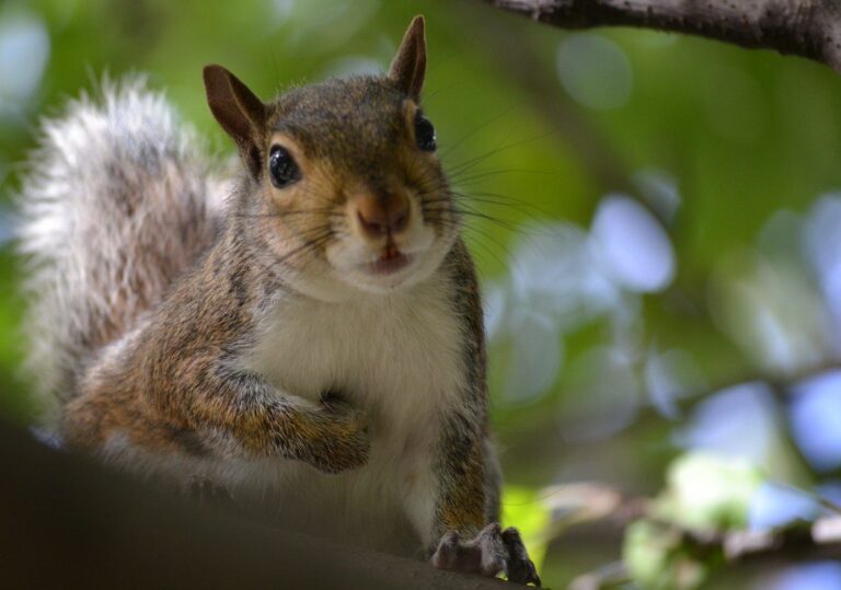
| Squirrel | Both fox and gray squirrel are common. |
Game you may pursue on Deep Fork WMA: Deer, Doves, Rails, Gallinules, Crows, Turkey, Trapping, Quail, Squirrels, Rabbits, Snipe, Woodcock, Furbearers, Waterfowl.
From the agency record (Oklahoma Department of Wildlife Conservation); checked November 3, 2026.
Nearby
Places to hunt and shoot around Deep Fork Wildlife Management Area
How ODWC runs Deep Fork WMA
Deep Fork WMA runs under ODWC area rules that ban bait, allow only portable stands and limit camping to 16 days in a row. Out-of-state hunters on Deep Fork WMA use the free ODWC area check-in each visit. Visitors who are not hunting or fishing need a Wildlife Conservation Passport ($46 resident / $239 nonresident) or an ODWC license to be on Deep Fork WMA. The WDUs on Deep Fork WMA follow the 1 p.m. waterfowl close and the nontoxic shot rule.
What ODWC prints first for Deep Fork WMA
- All shotgun hunting is restricted to federally approved nontoxic shot on the WDU portions.
The 2026-27 table for Deep Fork WMA closes 0 seasons outright and restricts 12 more; 10 run on the normal state dates.
| Segment | Area status | Detail |
|---|---|---|
| Deer Archery | Statewide dates | – |
| Holiday Antlerless Deer Gun | Statewide dates | – |
| Youth Deer Gun | Statewide dates | – |
| Deer Muzzleloader | Statewide dates | – |
| Dove | Statewide dates | – |
| Rail | Statewide dates | – |
| Gallinule | Statewide dates | – |
| Crow | Statewide dates | – |
| Turkey Fall Archery | Statewide dates | – |
| Trapping | Statewide dates | – |
| Deer Gun | Restricted | Open during the first nine days only. |
| Quail | Restricted | Closed during the first nine days of deer gun season. |
| Squirrel | Restricted | Closed during the first nine days of deer gun season. |
| Rabbit | Restricted | Closed during the first nine days of deer gun season. |
| Snipe | Restricted | Closed during the first nine days of deer gun season. |
| Woodcock | Restricted | Closed during the first nine days of deer gun season. |
| Pursuit with Hounds for Furbearers | Restricted | Closed during the first nine days of deer gun season. |
| Predator/Furbearer Calling | Restricted | Closed during the first nine days of deer gun season. |
| Turkey Fall Gun | Restricted | Tom only, shotgun only. |
| Duck, Merganser and Coot | Restricted | Hunting hours for waterfowl close at 1 p.m. daily on the WDU portion. The Harold Stuart Marsh (Refuge Unit) is closed to all waterfowl hunting. |
| Turkey Spring | Restricted | One-tom limit; seasons combined, area combined. |
| Youth Turkey Spring | Restricted | One-tom limit; seasons combined, area combined. |
Deep Fork WMA: added restrictions
- Hunter and angler camping is allowed within 50 yards of open roads.
| Department rule | Detail |
|---|---|
| Bait | Not allowed |
| Stands | Portable only |
| Stand removal | Within 14 days |
| Marking | ODWC customer ID |
| Target shooting | Designated ranges |
| Vehicles | Open roads only |
| Camping limit | 16 days in a row |
- Deep Fork WMA: Swift Bottoms WDU , Hunting Contact (918) 759-1816
- Eufaula WMA: Deep Fork WDU , Hunting Contact (918) 617-1113
Sources: source, source, source, source (Oklahoma Department of Wildlife Conservation). Checked November 3, 2026.
Deer zone and elk rules near Deep Fork WMA
| County rule | Creek County | Okfuskee County |
|---|---|---|
| Antlerless zone | 5 (72%), 2 (28%) | 5 |
| Elk zone | Northeast | Northeast |
| Bear area | No | No |
| Pronghorn | No season | No season |
| Fall gun turkey | Open | Open |
| Pheasant | No season | No season |
| Duck dates | Zones 1 and 2 | Zones 1 and 2 |
| Crane, jackrabbit | No season | No season |
| CWD surveillance | Outside | Outside |
| ODWC region | Central | Central |
| Warden district | No. 4 | No. 4 |
Zone 5 (Muzzleloader 2, gun 2) covers Deep Fork WMA on the GIS overlay; the legal line is the road shown on the ODWC antlerless zone map. Whatever the zone, the combined limit stays at six deer, two antlered at most. Private-land elk in Creek County run under the Northeast Zone (quota 20). Creek County allows fall gun turkey.
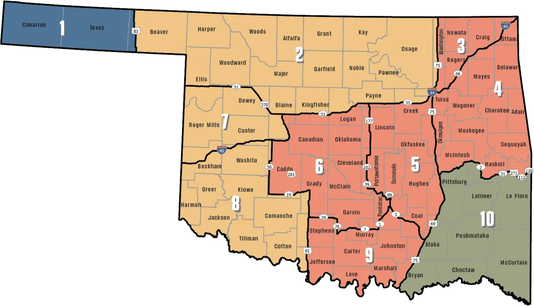
ODWC antlerless deer zones, elk zones, bear area, fall turkey counties, CWD rules; checked November 3, 2026.
Deer checked near Deep Fork WMA
106 deer were reported from Deep Fork WMA in the latest Big Game Harvest Report. The 2025-26 county figure for Creek County is 2,940 deer, 1,602 antlered, 5th of 77. 883 fell to archery, 357 to muzzleloaders and 1,700 to guns.
| Year | Name | Archery | Primitive | Rifle/shotgun | Total |
|---|---|---|---|---|---|
| 2024 | Deep Fork WMA | 18 | 24 | 50 | 92 |
| 2025 | Deep Fork WMA | 19 | 24 | 63 | 106 |
ODWC 2025-26 Big Game Harvest Report and earlier ODWC harvest reports (harvest.json); checked November 3, 2026.
Deep Fork WMA and the closest public tracts
Heyburn WMA is the nearest other public area, 22 mi north. For walk-in private land, try Seminole OLAP limited access LA001, 25 mi.
| Nearby | Kind | Acres | County | Miles | Heading |
|---|---|---|---|---|---|
| Heyburn WMA | WMA | 5,725 | Creek | 22 mi | north |
| Heyburn Lake (Corps) | Corps lake | – | Creek | 23 mi | northeast |
| Okmulgee GMA | GMA | 5,939 | Okmulgee | 24 mi | east |
| Okmulgee PHA | PHA | 3,676 | Okmulgee | 24 mi | east |
| Okmulgee WMA | WMA | 9,615 | Okmulgee | 24 mi | east |
| Keystone WMA | WMA | 20,686 | Creek, Osage | 32 mi | north |
Points: ODWC Public WMA Boundaries layer (polygon centroid of the largest part). Straight-line distances. Statewide public land map.
Deep Fork WMA hunting calendar
For Deep Fork WMA the list holds 63 seasons for 2026-27: big game, turkey, upland birds, small game, waterfowl and predators.
| Animal | Season type | Where | Start | Finish | Right now |
|---|---|---|---|---|---|
| White-tailed deer | Archery | Zone 2, 7, 8 | Oct 1, 2026 | Jan 15, 2027 | |
| White-tailed deer | Youth gun | Zone 2, 7, 8 | Oct 16, 2026 | Oct 18, 2026 | |
| White-tailed deer | Muzzleloader | Zone 2, 7, 8 | Oct 24, 2026 | Nov 1, 2026 | |
| White-tailed deer | Gun | Zone 2, 7, 8 | Nov 21, 2026 | Dec 6, 2026 | |
| White-tailed deer | Holiday antlerless | Zone 2, 7, 8 | Dec 18, 2026 | Dec 31, 2026 | |
| White-tailed deer | Archery | Zone 3, 4, 5, 6, 9 | Oct 1, 2026 | Jan 15, 2027 | |
| White-tailed deer | Youth gun | Zone 3, 4, 5, 6, 9 | Oct 16, 2026 | Oct 18, 2026 | |
| White-tailed deer | Muzzleloader | Zone 3, 4, 5, 6, 9 | Oct 24, 2026 | Nov 1, 2026 | |
| White-tailed deer | Gun | Zone 3, 4, 5, 6, 9 | Nov 21, 2026 | Dec 6, 2026 | |
| White-tailed deer | Holiday antlerless | Zone 3, 4, 5, 6, 9 | Dec 18, 2026 | Dec 31, 2026 | |
| Mule deer | All deer seasons | Statewide | Oct 1, 2026 | Jan 15, 2027 | |
| Elk | Archery | Northeast elk zone | Oct 1, 2026 | Jan 15, 2027 | |
| Elk | Youth elk gun | Northeast elk zone | Oct 16, 2026 | Oct 18, 2026 | |
| Elk | Muzzleloader | Northeast elk zone | Oct 24, 2026 | Nov 1, 2026 | |
| Elk | Gun | Northeast elk zone | Nov 21, 2026 | Dec 6, 2026 | |
| Elk | Holiday antlerless elk | Northeast elk zone | Dec 18, 2026 | Dec 31, 2026 | |
| Wild turkey | Youth fall turkey | Open counties | Oct 16, 2026 | Oct 18, 2026 | |
| Wild turkey | Fall Gun | Open counties | Oct 31, 2026 | Nov 20, 2026 | |
| Wild turkey | Fall Archery | Statewide | Oct 1, 2026 | Jan 15, 2027 | |
| Wild turkey | Youth Spring | Statewide | Apr 10, 2027 | Apr 11, 2027 | |
| Wild turkey | Spring | Statewide | Apr 16, 2027 | May 16, 2027 | |
| Feral hogs | Private land | Private land | Jul 1, 2026 | Jun 30, 2027 | |
| Quail | Season | Statewide | Nov 14, 2026 | Feb 15, 2027 | |
| Rabbits | Season | Statewide | Oct 1, 2026 | Mar 15, 2027 | |
| Squirrels | Season | Statewide | May 15, 2026 | Feb 28, 2027 | |
| Doves | Segment 1 | Statewide | Sep 1, 2026 | Oct 31, 2026 | |
| Doves | Segment 2 | Statewide | Dec 1, 2026 | Dec 29, 2026 | |
| Teal | September Teal | Statewide | Sep 12, 2026 | Sep 20, 2026 | |
| Ducks | Youth and veteran day | Zones 1 and 2 | Nov 7, 2026 | Nov 7, 2026 | |
| Ducks | Regular segment 1 | Zones 1 and 2 | Nov 14, 2026 | Dec 6, 2026 | |
| Ducks | Regular segment 2 | Zones 1 and 2 | Dec 12, 2026 | Jan 31, 2027 | |
| Ducks | Youth and veteran day | Zones 1 and 2 | Feb 6, 2027 | Feb 6, 2027 | |
| Canada geese | September Canada goose | Statewide | Sep 12, 2026 | Sep 21, 2026 | |
| Dark geese | Segment 1 | Statewide | Nov 7, 2026 | Dec 6, 2026 | |
| Dark geese | Segment 2 | Statewide | Dec 12, 2026 | Feb 14, 2027 | |
| Specklebellies | Segment 1 | Statewide | Nov 7, 2026 | Dec 6, 2026 | |
| Specklebellies | Segment 2 | Statewide | Dec 12, 2026 | Feb 7, 2027 | |
| Light geese | Segment 1 | Statewide | Nov 7, 2026 | Dec 6, 2026 | |
| Light geese | Segment 2 | Statewide | Dec 12, 2026 | Feb 14, 2027 | |
| Light geese | Conservation order | Statewide | Feb 15, 2027 | Mar 30, 2027 | |
| Woodcock | Season | Statewide | Nov 7, 2026 | Dec 21, 2026 | |
| Coyote | Year-round | Statewide | Jul 1, 2026 | Jun 30, 2027 | |
| Bobcat | Furbearer season | Statewide | Dec 1, 2026 | Feb 28, 2027 | |
| Gray fox | Furbearer season | Statewide | Dec 1, 2026 | Feb 28, 2027 | |
| Red fox | Furbearer season | Statewide | Dec 1, 2026 | Feb 28, 2027 | |
| Raccoon | Year-round | Statewide | Jul 1, 2026 | Jun 30, 2027 | |
| Prairie dog | Year-round | Statewide | Jul 1, 2026 | Jun 30, 2027 | |
| Beaver | Year-round | Statewide | Jul 1, 2026 | Jun 30, 2027 | |
| Nutria | Year-round | Statewide | Jul 1, 2026 | Jun 30, 2027 | |
| Striped skunk | Year-round | Statewide | Jul 1, 2026 | Jun 30, 2027 | |
| Bullfrogs | Year-round | Statewide | Jul 1, 2026 | Jun 30, 2027 | |
| Rails | Season | Statewide | Sep 1, 2026 | Nov 9, 2026 | |
| Gallinules | Season | Statewide | Sep 1, 2026 | Nov 9, 2026 | |
| Snipe | Season | Statewide | Sep 26, 2026 | Jan 10, 2027 | |
| Crows | Segment 1 | Statewide | Oct 10, 2026 | Nov 16, 2026 | |
| River otter | Furbearer season | Statewide | Dec 1, 2026 | Feb 28, 2027 | |
| Badger | Furbearer season | Statewide | Dec 1, 2026 | Feb 28, 2027 | |
| Mink | Furbearer season | Statewide | Dec 1, 2026 | Feb 28, 2027 | |
| Muskrat | Furbearer season | Statewide | Dec 1, 2026 | Feb 28, 2027 | |
| Opossum | Furbearer season | Statewide | Dec 1, 2026 | Feb 28, 2027 | |
| Weasel | Furbearer season | Statewide | Dec 1, 2026 | Feb 28, 2027 | |
| Crows | Segment 2 | Statewide | Dec 9, 2026 | Mar 4, 2027 | |
| Rattlesnakes | Season | Statewide | Mar 1, 2027 | Jun 30, 2027 |
From the ODWC hunting regulations and the 2026-2027 Oklahoma Fishing and Hunting Regulations (Oklahoma Department of Wildlife Conservation), checked November 3, 2026.
Deep Fork WMA: nearest towns, offices and shops
Closest town covered here: Welty, roughly 4.1 mi away. Okemah (3,066 residents) has the most services, 19 mi away. Small places on the way: Milfay (7.9 mi) and Depew (10 mi, 415 people). ODWC lists these game warden numbers for the area: (918) 625-6801 (Creek); (918) 625-6363 (Creek); (580) 320-2949 (Okfuskee).
| Town | County | 2024 population | Away | Which way |
|---|---|---|---|---|
| Welty | Okfuskee | – | 4.1 mi | southeast |
| Okemah | Okfuskee | 3,066 | 19 mi | southeast |
| Chandler | Lincoln | 2,944 | 20 mi | west |
| Kellyville | Creek | 1,049 | 27 mi | northeast |
| Preston | Okmulgee | – | 28 mi | east |
Towns from places.json and census_places.json (Census 2024); offices and businesses from services.json; warden numbers from the ODWC area page or warden directory; straight-line miles. Checked November 3, 2026.
Deep Fork WMA legal light
Big game legal light around Deep Fork WMA starts 30 minutes before sunrise and ends 30 minutes after sunset; ducks and geese end at sunset.
| Day | Marker | Sun up | Sun down | Deer window | Duck window | Upland |
|---|---|---|---|---|---|---|
| Oct 1, 2026 | Archery deer opens | 7:19 a.m. | 7:11 p.m. | 6:49 a.m. to 7:41 p.m. | 6:49 a.m. to 7:11 p.m. | 7:19 a.m. to 7:11 p.m. |
| Oct 24, 2026 | Muzzleloader opens | 7:39 a.m. | 6:40 p.m. | 7:09 a.m. to 7:10 p.m. | 7:09 a.m. to 6:40 p.m. | 7:39 a.m. to 6:40 p.m. |
| Nov 21, 2026 | Gun deer opens | 7:07 a.m. | 5:16 p.m. | 6:37 a.m. to 5:46 p.m. | 6:37 a.m. to 5:16 p.m. | 7:07 a.m. to 5:16 p.m. |
| Dec 6, 2026 | Gun deer closes | 7:22 a.m. | 5:12 p.m. | 6:52 a.m. to 5:42 p.m. | 6:52 a.m. to 5:12 p.m. | 7:22 a.m. to 5:12 p.m. |
| Dec 21, 2026 | Shortest day | 7:32 a.m. | 5:15 p.m. | 7:02 a.m. to 5:45 p.m. | 7:02 a.m. to 5:15 p.m. | 7:32 a.m. to 5:15 p.m. |
| Jan 15, 2027 | Archery closes | 7:35 a.m. | 5:33 p.m. | 7:05 a.m. to 6:03 p.m. | 7:05 a.m. to 5:33 p.m. | 7:35 a.m. to 5:33 p.m. |
| Apr 16, 2027 | Spring turkey | 6:52 a.m. | 7:59 p.m. | 6:22 a.m. to 8:29 p.m. | 6:22 a.m. to 7:59 p.m. | 6:52 a.m. to 7:59 p.m. |
Hours rules from the ODWC big game regulations and the 2026-2027 Oklahoma Fishing and Hunting Regulations; sunrise and sunset worked out for this location with the NOAA solar formula (Central Time); checked November 3, 2026. Legal hours for every county.
Deep Fork WMA photo row


ODWC bench and private ranges before Deep Fork Wildlife Management Area
Okmulgee GMA Shooting Range (public, license needed) is 23 miles from Deep Fork Wildlife Management Area. Club or commercial ranges under 30 miles away sit beside it.
From ODWC’s WMA shooting range list and WMA pages, operators’ pages and directory listings, checked November 3, 2026.
Deep Fork WMA questions and answers
What acreage do the sources give for Deep Fork WMA?
12,820 acres, per the ODWC area page.
Which ODWC region does Deep Fork WMA fall under?
It lies in Creek and Okfuskee counties (ODWC Central Region). Nearest town covered here: Welty (4.1 mi).
Which antlerless deer zone takes in Deep Fork WMA?
Zone 5 (Muzzleloader 2, gun 2); the season total stays six deer, no more than two antlered.
Besides a license, what does Deep Fork WMA require?
An Oklahoma hunting license (or exemption) and the species licenses for what you hunt; nonresidents check in at listed areas.
What animals does Deep Fork WMA carry seasons for?
Sources name deer, doves, rails, gallinules, crows, turkey, trapping, quail, squirrels, rabbits, snipe, woodcock, furbearers and waterfowl.
Does the bait ban cover Deep Fork WMA?
No. ODWC makes it unlawful to place bait or hunt over it on land the Department owns or manages.
How far is the next public hunting area from Deep Fork WMA?
Heyburn WMA sits 22 mi away.
Who answers questions about Deep Fork WMA?
Land manager on record: Oklahoma Department of Wildlife Conservation. Contact number (918) 759-1816.
Which hours are legal for deer on Deep Fork WMA?
For November 21, 2026, roughly 6:37 a.m. to 5:46 p.m. for deer (Creek County centre, NOAA solar formula). Ducks in the WDUs end at 1 p.m.
How much fluorescent orange is required on Deep Fork WMA?
Yes: 400 square inches above the waist and on the head for firearm big game; waterfowl, dove and crane hunters are exempt.
Can I pitch a tent at Deep Fork WMA?
Primitive camping is permitted adjacent to county roads and access points, but there are no designated campgrounds.
What does the ODWC harvest report show for Deep Fork WMA?
106 deer were checked from it in 2025-26.
Deep Fork WMA trip checklist
Area rules, closures and controlled hunt dates on Deep Fork WMA can change; posted signs and the ODWC page have the last word.
Sources: source · source · source · source · source · source; regulations from the 2026-2027 Oklahoma Fishing and Hunting Regulations. Checked November 3, 2026.
Other photos on this page: Thomas & Dianne Jones (CC BY 2.0); Volker Schmidt (CC0 1.0); DaPuglet (CC BY-SA 2.0).