Home › Oklahoma › Public land › Harper OLAP tract H010
OLAP walk-in · OK
Harper County OLAP H010
What the sources say about this OLAP walk-in tract, 476 acres, in Harper County.
Photo: NOAA National Severe Storms Laboratory (CC BY 2.0)
Getting to Harper County OLAP Walk-In Hunting Area H010
Parking, trailheads and gates near Harper County OLAP Walk-In Hunting Area H010
- Parking areaParking · 1.8 mi from the centreDirections
Parking, trailhead and gate locations come from OpenStreetMap contributors. Roads into public land can be gated or seasonal; check with the managing agency before you go.
Harper OLAP tract H010: permit and walk-in rules
| Topic | Rule |
|---|---|
| Permit | Land Access Permit |
| Fee | $100 / $200 |
| Weapons | Archery, shotgun |
| Largest shot | T |
| Access | Foot only |
| Open | Sept. 1 to May 16 |
| Quail, pheasant | End 4:30 p.m. |
| Elk | Closed |
| Camping | Not allowed |
Land Access Permit first, then hunt: $100 resident / $200 nonresident, valid January 1 to December 31, needed for Harper OLAP tract H010 and every other OLAP property. The weapon rule on walk-in ground is archery and shotgun only, with T shot the largest size and slugs prohibited. Plan the walk: the tract is foot-access only, from two hours before sunrise to one hour after sunset. Quail and pheasant hunting on OLAP stops at 4:30 p.m., earlier than the usual sunset close. Leave the camp gear: no camping, fires or alcohol, and elk may not be hunted. Trap types are restricted to water sets, box traps and enclosed-trigger designs.
Sources: ODWC OLAP layer, OLAP hunting regulations, OLAP program page, license fees. Checked November 3, 2026.
Nearby
Places to hunt and shoot around Harper County OLAP Walk-In Hunting Area H010
Facts on Harper OLAP tract H010
Walk-in hunters share 476 acres here, private ground leased by ODWC in Harper County. Harper County has 26 OLAP hunting tracts (12,689 acres); by size Harper OLAP tract H010 ranks 6th. ODWC describes the cover as "Grassland, plum mottes in rivines". Game on the layer: dove, quail and deer. Measured in GIS the polygon is 482 acres.
| What | Value |
|---|---|
| OLAP ID | Harper_H010 |
| Acres (layer) | 476 |
| GIS acres | 482 |
| Cover | Grassland, plum mottes in rivines |
| Season | Sept. 1 to May 16 |
| County | Harper County |
| County rank | 6 of 26 |
| PATH tract | No |
From the ODWC OLAP layer (OLAP_UpdatedLayers_062626); checked November 3, 2026.
Deer zone and elk rules near Harper OLAP tract H010
| Setting | Harper County |
|---|---|
| Antlerless zone | 2 |
| Elk zone | Northwest |
| Bear area | No |
| Pronghorn | No season |
| Fall gun turkey | Open |
| Pheasant | Whole county |
| Duck dates | Zones 1 and 2 |
| Crane, jackrabbit | West of I-35 |
| CWD surveillance | Outside |
| ODWC region | Northwest |
| Warden district | No. 8 |
The ODWC zone layer puts Harper OLAP tract H010 in antlerless Zone 2 (Muzzleloader 4, gun 4). Zone lines follow roads, so near a boundary the ODWC antlerless zone map decides. The season cap is six deer combined, two antlered at most; 3 inches of antler makes a deer antlered. The Northwest Zone takes in Harper County, but OLAP rules keep elk hunters off Harper OLAP tract H010. Harper County is an open fall gun turkey county. The pheasant area takes in the whole county. Harper County lies wholly or partly west of I-35, where sandhill crane and jackrabbit seasons apply.
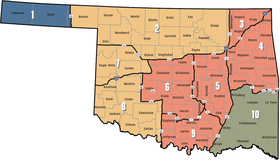
ODWC antlerless deer zones, elk zones, bear area, fall turkey counties, CWD rules; checked November 3, 2026.
Harper OLAP tract H010 on the map with its neighbors
If Harper OLAP tract H010 is busy, Hal and Fern Cooper WMA is 15 mi away to the southeast. OLAP neighbor: Harper OLAP tract H004, 0.5 mi, west.
| Place | Type | Acres | County | Miles off | Direction |
|---|---|---|---|---|---|
| Hal and Fern Cooper WMA | WMA | 16,120 | Harper, Woodward | 15 mi | southeast |
| Fort Supply Lake (Corps) | Corps lake | – | Woodward | 17 mi | south |
| Cimarron Bluff WMA | WMA | 3,590 | Harper | 18 mi | east |
| Cimarron Hills WMA | WMA | 4,200 | Woods | 19 mi | northeast |
| Fort Supply WMA | WMA | 5,462 | Woodward | 19 mi | south |
| Lake Evans Chambers | Department lake | 204 | Beaver | 31 mi | west |
Nearest walk-ins to Harper OLAP tract H010
| Place | Type | Acres | County | Miles off | Direction |
|---|---|---|---|---|---|
| Harper OLAP tract H004 | OLAP walk-in | 441 | Harper | 0.5 mi | west |
| Harper OLAP tract H003 | OLAP walk-in | 160 | Harper | 1.9 mi | west |
| Harper OLAP tract H005 | OLAP walk-in | 257 | Harper | 2.8 mi | southeast |
| Harper OLAP tract H021 | OLAP walk-in | 360 | Harper | 4.0 mi | east |
Points: ODWC OLAP Walk-In Access layer (tract polygon) (polygon centroid). Straight-line distances. Statewide public land map.
What hunters took near Harper OLAP tract H010
In 2025-26 hunters in Harper County reported 468 deer off private and other non-WMA land; 330 carried antlers. Archery took 66, muzzleloaders 28 and guns 374. Harper County also reported 18 mule deer in 2025-26.
ODWC 2025-26 Big Game Harvest Report and earlier ODWC harvest reports (harvest.json); checked November 3, 2026.
Towns and ODWC offices near Harper OLAP tract H010
Harper OLAP tract H010 lies 4.5 mi from Buffalo. Woodward counted 11,750 people in 2024, the most of the five. Closer small towns: May (12 mi, 30 people). For a warden, District 8 captain Ben Bickerstaff answers at (580) 304-6034.
| Town | County | People (2024) | Distance | Direction |
|---|---|---|---|---|
| Buffalo | Harper | 1,019 | 4.5 mi | north |
| Selman | Harper | – | 9.3 mi | east |
| Fort Supply | Woodward | 319 | 14 mi | south |
| Woodward | Woodward | 11,750 | 27 mi | southeast |
| Arnett | Ellis | 486 | 44 mi | south |
Towns from places.json and census_places.json (Census 2024); offices and businesses from services.json; warden numbers from the ODWC area page or warden directory; straight-line miles. Checked November 3, 2026.
Harper OLAP tract H010 openers, game by game
Wildlife management areas can shorten or close these dates under their own area rules; this table is the county-wide picture for Harper OLAP tract H010.
| Species | Hunt | Applies to | First day | Last day | Status |
|---|---|---|---|---|---|
| White-tailed deer | Archery | Zone 2, 7, 8 | Oct 1, 2026 | Jan 15, 2027 | |
| White-tailed deer | Youth gun | Zone 2, 7, 8 | Oct 16, 2026 | Oct 18, 2026 | |
| White-tailed deer | Muzzleloader | Zone 2, 7, 8 | Oct 24, 2026 | Nov 1, 2026 | |
| White-tailed deer | Gun | Zone 2, 7, 8 | Nov 21, 2026 | Dec 6, 2026 | |
| White-tailed deer | Holiday antlerless | Zone 2, 7, 8 | Dec 18, 2026 | Dec 31, 2026 | |
| Mule deer | All deer seasons | Statewide | Oct 1, 2026 | Jan 15, 2027 | |
| Elk | Archery | Northwest elk zone | Oct 1, 2026 | Jan 15, 2027 | |
| Elk | Youth elk gun | Northwest elk zone | Oct 16, 2026 | Oct 18, 2026 | |
| Elk | Muzzleloader | Northwest elk zone | Oct 24, 2026 | Nov 1, 2026 | |
| Elk | Gun | Northwest elk zone | Nov 21, 2026 | Dec 6, 2026 | |
| Elk | Holiday antlerless elk | Northwest elk zone | Dec 18, 2026 | Dec 31, 2026 | |
| Wild turkey | Youth fall turkey | Open counties | Oct 16, 2026 | Oct 18, 2026 | |
| Wild turkey | Fall Gun | Open counties | Oct 31, 2026 | Nov 20, 2026 | |
| Wild turkey | Fall Archery | Statewide | Oct 1, 2026 | Jan 15, 2027 | |
| Wild turkey | Youth Spring | Statewide | Apr 10, 2027 | Apr 11, 2027 | |
| Wild turkey | Spring | Statewide | Apr 16, 2027 | May 16, 2027 | |
| Feral hogs | Private land | Private land | Jul 1, 2026 | Jun 30, 2027 | |
| Quail | Season | Statewide | Nov 14, 2026 | Feb 15, 2027 | |
| Pheasant | Season | Pheasant counties | Dec 1, 2026 | Jan 31, 2027 | |
| Rabbits | Season | Statewide | Oct 1, 2026 | Mar 15, 2027 | |
| Jackrabbit | Season | West of I-35 | Oct 1, 2026 | Mar 15, 2027 | |
| Squirrels | Season | Statewide | May 15, 2026 | Feb 28, 2027 | |
| Doves | Segment 1 | Statewide | Sep 1, 2026 | Oct 31, 2026 | |
| Doves | Segment 2 | Statewide | Dec 1, 2026 | Dec 29, 2026 | |
| Teal | September Teal | Statewide | Sep 12, 2026 | Sep 20, 2026 | |
| Ducks | Youth and veteran day | Zones 1 and 2 | Nov 7, 2026 | Nov 7, 2026 | |
| Ducks | Regular segment 1 | Zones 1 and 2 | Nov 14, 2026 | Dec 6, 2026 | |
| Ducks | Regular segment 2 | Zones 1 and 2 | Dec 12, 2026 | Jan 31, 2027 | |
| Ducks | Youth and veteran day | Zones 1 and 2 | Feb 6, 2027 | Feb 6, 2027 | |
| Canada geese | September Canada goose | Statewide | Sep 12, 2026 | Sep 21, 2026 | |
| Dark geese | Segment 1 | Statewide | Nov 7, 2026 | Dec 6, 2026 | |
| Dark geese | Segment 2 | Statewide | Dec 12, 2026 | Feb 14, 2027 | |
| Specklebellies | Segment 1 | Statewide | Nov 7, 2026 | Dec 6, 2026 | |
| Specklebellies | Segment 2 | Statewide | Dec 12, 2026 | Feb 7, 2027 | |
| Light geese | Segment 1 | Statewide | Nov 7, 2026 | Dec 6, 2026 | |
| Light geese | Segment 2 | Statewide | Dec 12, 2026 | Feb 14, 2027 | |
| Light geese | Conservation order | Statewide | Feb 15, 2027 | Mar 30, 2027 | |
| Sandhill crane | Season | West of I-35 | Oct 17, 2026 | Jan 17, 2027 | |
| Woodcock | Season | Statewide | Nov 7, 2026 | Dec 21, 2026 | |
| Coyote | Year-round | Statewide | Jul 1, 2026 | Jun 30, 2027 | |
| Bobcat | Furbearer season | Statewide | Dec 1, 2026 | Feb 28, 2027 | |
| Gray fox | Furbearer season | Statewide | Dec 1, 2026 | Feb 28, 2027 | |
| Red fox | Furbearer season | Statewide | Dec 1, 2026 | Feb 28, 2027 | |
| Raccoon | Year-round | Statewide | Jul 1, 2026 | Jun 30, 2027 | |
| Prairie dog | Year-round | Statewide | Jul 1, 2026 | Jun 30, 2027 | |
| Beaver | Year-round | Statewide | Jul 1, 2026 | Jun 30, 2027 | |
| Nutria | Year-round | Statewide | Jul 1, 2026 | Jun 30, 2027 | |
| Striped skunk | Year-round | Statewide | Jul 1, 2026 | Jun 30, 2027 | |
| Bullfrogs | Year-round | Statewide | Jul 1, 2026 | Jun 30, 2027 | |
| Rails | Season | Statewide | Sep 1, 2026 | Nov 9, 2026 | |
| Gallinules | Season | Statewide | Sep 1, 2026 | Nov 9, 2026 | |
| Snipe | Season | Statewide | Sep 26, 2026 | Jan 10, 2027 | |
| Crows | Segment 1 | Statewide | Oct 10, 2026 | Nov 16, 2026 | |
| River otter | Furbearer season | Statewide | Dec 1, 2026 | Feb 28, 2027 | |
| Badger | Furbearer season | Statewide | Dec 1, 2026 | Feb 28, 2027 | |
| Mink | Furbearer season | Statewide | Dec 1, 2026 | Feb 28, 2027 | |
| Muskrat | Furbearer season | Statewide | Dec 1, 2026 | Feb 28, 2027 | |
| Opossum | Furbearer season | Statewide | Dec 1, 2026 | Feb 28, 2027 | |
| Weasel | Furbearer season | Statewide | Dec 1, 2026 | Feb 28, 2027 | |
| Crows | Segment 2 | Statewide | Dec 9, 2026 | Mar 4, 2027 | |
| Rattlesnakes | Season | Statewide | Mar 1, 2027 | Jun 30, 2027 |
From the ODWC hunting regulations and the 2026-2027 Oklahoma Fishing and Hunting Regulations (Oklahoma Department of Wildlife Conservation), checked November 3, 2026.
Legal hunting times, Harper OLAP tract H010
Quail and pheasant hours are sunrise to sunset, shorter than the big game window, and OLAP walk-in land closes to them at 4:30 p.m.
| Day | Moment | First sun | Last sun | Deer hours | Duck hours | Bird dog hours |
|---|---|---|---|---|---|---|
| Oct 1, 2026 | Archery deer opens | 7:33 a.m. | 7:24 p.m. | 7:03 a.m. to 7:54 p.m. | 7:03 a.m. to 7:24 p.m. | 7:33 a.m. to 7:24 p.m. |
| Oct 24, 2026 | Muzzleloader opens | 7:53 a.m. | 6:52 p.m. | 7:23 a.m. to 7:22 p.m. | 7:23 a.m. to 6:52 p.m. | 7:53 a.m. to 6:52 p.m. |
| Nov 21, 2026 | Gun deer opens | 7:23 a.m. | 5:27 p.m. | 6:53 a.m. to 5:57 p.m. | 6:53 a.m. to 5:27 p.m. | 7:23 a.m. to 5:27 p.m. |
| Dec 6, 2026 | Gun deer closes | 7:37 a.m. | 5:23 p.m. | 7:07 a.m. to 5:53 p.m. | 7:07 a.m. to 5:23 p.m. | 7:37 a.m. to 5:23 p.m. |
| Dec 21, 2026 | Shortest day | 7:47 a.m. | 5:26 p.m. | 7:17 a.m. to 5:56 p.m. | 7:17 a.m. to 5:26 p.m. | 7:47 a.m. to 5:26 p.m. |
| Jan 15, 2027 | Archery closes | 7:50 a.m. | 5:44 p.m. | 7:20 a.m. to 6:14 p.m. | 7:20 a.m. to 5:44 p.m. | 7:50 a.m. to 5:44 p.m. |
| Apr 16, 2027 | Spring turkey | 7:05 a.m. | 8:13 p.m. | 6:35 a.m. to 8:43 p.m. | 6:35 a.m. to 8:13 p.m. | 7:05 a.m. to 8:13 p.m. |
Hours rules from the ODWC big game regulations and the 2026-2027 Oklahoma Fishing and Hunting Regulations; sunrise and sunset worked out for this location with the NOAA solar formula (Central Time); checked November 3, 2026. Legal hours for every county.
Landscape and game photos for Harper OLAP tract H010


Ranges to visit before hunting Harper County OLAP Walk-In Hunting Area H010
Drive about 22 miles from Harper County OLAP Walk-In Hunting Area H010 to reach Fort Supply WMA Shooting Range, the nearest free bench. Ranges within 30 miles take the other cards.
From ODWC’s WMA shooting range list and WMA pages, operators’ pages and directory listings, checked November 3, 2026.
Hunters ask about Harper OLAP tract H010
What are the camping rules for Harper OLAP tract H010?
No camping on walk-in tracts. Nearest town page: Buffalo.
How many deer were reported near Harper OLAP tract H010?
Harper County reported 468 deer off private and non-WMA land in 2025-26, 73rd of 77 counties.
How long is deer season at Harper OLAP tract H010?
Statewide archery runs Oct 1, 2026 to Jan 15, 2027 and gun Nov 21, 2026 to Dec 6, 2026; area rules can close segments. Remember: no rifles or slugs on OLAP.
Do elk seasons reach Harper OLAP tract H010?
Elk are excluded on OLAP; county zone Northwest Zone.
What corner of the state is Harper OLAP tract H010 in?
Harper OLAP tract H010 is in Harper County, part of the ODWC Northwest Region. Buffalo lies roughly 4.5 mi from it.
How many walk-in areas does Harper County hold?
26 OLAP hunting tracts (12,689 acres).
What permits do hunters carry on Harper OLAP tract H010?
Hunting license and Land Access Permit ($100 resident / $200 nonresident); lifetime holders still need the permit.
What is the published size of Harper OLAP tract H010?
476 acres on file, from the ODWC OLAP layer.
What are the bait rules on Harper OLAP tract H010?
No. Bait is prohibited on Department lands.
What doe limit goes with Harper OLAP tract H010?
It falls in Zone 2 (Muzzleloader 4, gun 4). Confirm on the ODWC zone map near a boundary road. The area table can tighten this.
What agency sets the rules on Harper OLAP tract H010?
The Oklahoma Department of Wildlife Conservation (leased private land) runs it. Oklahoma City has the nearest ODWC office, 149 mi away.
Which game birds and animals are open at Harper OLAP tract H010?
The OLAP layer lists dove, quail, deer; other statewide seasons except elk are open too.
One more look before Harper OLAP tract H010
Confirm dates, permits and the antlerless zone for Harper OLAP tract H010 before the drive.
Sources: source · source · source · source; regulations from the 2026-2027 Oklahoma Fishing and Hunting Regulations. Checked November 3, 2026.
Other photos on this page: Wesley Fryer (CC BY 2.0); timmdecker (CC BY-SA 3.0); cuatrok77 (CC BY-SA 2.0).