Home › Oklahoma › Public land › Woods OLAP tract H014
Oklahoma OLAP walk-in tract
Woods County OLAP Walk-In Hunting Area H014 hunting
Public OLAP walk-in tract, 864 acres, in Woods County, ODWC Northwest Region.
Photo: Tinboy2341 (CC BY 4.0)
Getting to Woods County OLAP Walk-In Hunting Area H014
What the OLAP layer says about Woods OLAP tract H014
Woods OLAP tract H014 is a 864-acre walk-in tract that ODWC leases from a private landowner in Woods County. Of 24,159 OLAP acres in Woods County, spread over 21 tracts, this one is number 10 by size. The layer leaves the cover field blank for this tract. Species field: deer, dove, quail and turkey. GIS puts the shape at 871 acres.
| Fact | Woods OLAP tract H014 |
|---|---|
| OLAP ID | Woods_H014 |
| Acres (layer) | 864 |
| GIS acres | 871 |
| Cover | – |
| Season | Sept. 1 to May 16 |
| County | Woods County |
| County rank | 10 of 21 |
| PATH tract | No |
From the ODWC OLAP layer (OLAP_UpdatedLayers_062626); checked November 3, 2026.
Nearby
Places to hunt and shoot around Woods County OLAP Walk-In Hunting Area H014
Woods OLAP tract H014 access rules
| Rule | Setting |
|---|---|
| Permit | Land Access Permit |
| Fee | $100 / $200 |
| Weapons | Archery, shotgun |
| Largest shot | T |
| Access | Foot only |
| Open | Sept. 1 to May 16 |
| Quail, pheasant | End 4:30 p.m. |
| Elk | Closed |
| Camping | Not allowed |
The Land Access Permit costs $100 resident / $200 nonresident and is required on Woods OLAP tract H014 unless you are an Oklahoma resident under 18 or 64 or older on January 1. A shotgun loaded no larger than T, or a bow, is the legal kit; every rifle and muzzleloader is out. You may be on Woods OLAP tract H014 from two hours before sunrise until an hour after sunset, and vehicles stay on the road. Upland birds have a shorter day here: quail and pheasant end at 4:30 p.m. No elk hunting, no camping and no fires on walk-in ground. ODWC confines OLAP trapping to water sets and box or enclosed-trigger traps.
Sources: ODWC OLAP layer, OLAP hunting regulations, OLAP program page, license fees. Checked November 3, 2026.
Woods OLAP tract H014 zones and limits
| County rule | Woods County |
|---|---|
| Antlerless zone | 2 |
| Elk zone | Northwest |
| Bear area | No |
| Pronghorn | No season |
| Fall gun turkey | Open |
| Pheasant | Whole county |
| Duck dates | Zones 1 and 2 |
| Crane, jackrabbit | West of I-35 |
| CWD surveillance | SSA county |
| ODWC region | Northwest |
| Warden district | No. 8 |
Zone 2 (Muzzleloader 4, gun 4) covers Woods OLAP tract H014 on the GIS overlay; the legal line is the road shown on the ODWC antlerless zone map. Whatever the zone, the combined limit stays at six deer, two antlered at most. For elk, look elsewhere: OLAP bans it, and the Northwest Zone in Woods County is a private-land zone. Woods County allows fall gun turkey. Pheasant season covers the whole county; see the pheasant counties. Sandhill crane and jackrabbit are open in the parts of Woods County west of I-35 (details).
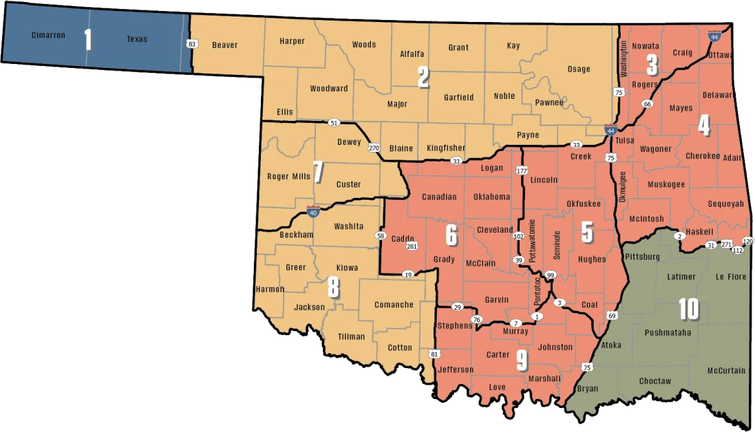
ODWC antlerless deer zones, elk zones, bear area, fall turkey counties, CWD rules; checked November 3, 2026.
Woods OLAP tract H014: reported deer
The 2025-26 county figure for Woods County is 1,031 deer, 641 antlered, 60th of 77. 193 fell to archery, 97 to muzzleloaders and 741 to guns. The county logged 2 mule deer last season.
ODWC 2025-26 Big Game Harvest Report and earlier ODWC harvest reports (harvest.json); checked November 3, 2026.
Woods OLAP tract H014 and the closest public tracts
Cimarron Bluff WMA is the nearest other public area, 19 mi west. Woods OLAP tract H017 is the next OLAP tract, 3.1 mi to the northwest.
| Nearby | Kind | Acres | County | Miles | Heading |
|---|---|---|---|---|---|
| Cimarron Bluff WMA | WMA | 3,590 | Harper | 19 mi | west |
| Cimarron Hills WMA | WMA | 4,200 | Woods | 22 mi | west |
| Major County WMA | WMA | 210 | Major | 32 mi | south |
| Hal and Fern Cooper WMA | WMA | 16,120 | Harper, Woodward | 34 mi | southwest |
| Sandhills WMA | WMA | 5,212 | Woods | 34 mi | southeast |
| Fort Supply Lake (Corps) | Corps lake | – | Woodward | 38 mi | southwest |
Other tracts by Woods OLAP tract H014
| Nearby | Kind | Acres | County | Miles | Heading |
|---|---|---|---|---|---|
| Woods OLAP tract H017 | OLAP walk-in | 425 | Woods | 3.1 mi | northwest |
| Woods OLAP tract H020 | OLAP walk-in | 2,720 | Woods | 3.7 mi | west |
| Woods OLAP tract H015 | OLAP walk-in | 1,176 | Woods | 3.9 mi | west |
| Woods OLAP tract H023 | OLAP walk-in | 740 | Woods | 4.0 mi | southeast |
Points: ODWC OLAP Walk-In Access layer (tract polygon) (polygon centroid). Straight-line distances. Statewide public land map.
Woods OLAP tract H014 hunting calendar
For Woods OLAP tract H014 the list holds 61 seasons for 2026-27: big game, turkey, upland birds, small game, waterfowl and predators.
| Animal | Season type | Where | Start | Finish | Right now |
|---|---|---|---|---|---|
| White-tailed deer | Archery | Zone 2, 7, 8 | Oct 1, 2026 | Jan 15, 2027 | |
| White-tailed deer | Youth gun | Zone 2, 7, 8 | Oct 16, 2026 | Oct 18, 2026 | |
| White-tailed deer | Muzzleloader | Zone 2, 7, 8 | Oct 24, 2026 | Nov 1, 2026 | |
| White-tailed deer | Gun | Zone 2, 7, 8 | Nov 21, 2026 | Dec 6, 2026 | |
| White-tailed deer | Holiday antlerless | Zone 2, 7, 8 | Dec 18, 2026 | Dec 31, 2026 | |
| Mule deer | All deer seasons | Statewide | Oct 1, 2026 | Jan 15, 2027 | |
| Elk | Archery | Northwest elk zone | Oct 1, 2026 | Jan 15, 2027 | |
| Elk | Youth elk gun | Northwest elk zone | Oct 16, 2026 | Oct 18, 2026 | |
| Elk | Muzzleloader | Northwest elk zone | Oct 24, 2026 | Nov 1, 2026 | |
| Elk | Gun | Northwest elk zone | Nov 21, 2026 | Dec 6, 2026 | |
| Elk | Holiday antlerless elk | Northwest elk zone | Dec 18, 2026 | Dec 31, 2026 | |
| Wild turkey | Youth fall turkey | Open counties | Oct 16, 2026 | Oct 18, 2026 | |
| Wild turkey | Fall Gun | Open counties | Oct 31, 2026 | Nov 20, 2026 | |
| Wild turkey | Fall Archery | Statewide | Oct 1, 2026 | Jan 15, 2027 | |
| Wild turkey | Youth Spring | Statewide | Apr 10, 2027 | Apr 11, 2027 | |
| Wild turkey | Spring | Statewide | Apr 16, 2027 | May 16, 2027 | |
| Feral hogs | Private land | Private land | Jul 1, 2026 | Jun 30, 2027 | |
| Quail | Season | Statewide | Nov 14, 2026 | Feb 15, 2027 | |
| Pheasant | Season | Pheasant counties | Dec 1, 2026 | Jan 31, 2027 | |
| Rabbits | Season | Statewide | Oct 1, 2026 | Mar 15, 2027 | |
| Jackrabbit | Season | West of I-35 | Oct 1, 2026 | Mar 15, 2027 | |
| Squirrels | Season | Statewide | May 15, 2026 | Feb 28, 2027 | |
| Doves | Segment 1 | Statewide | Sep 1, 2026 | Oct 31, 2026 | |
| Doves | Segment 2 | Statewide | Dec 1, 2026 | Dec 29, 2026 | |
| Teal | September Teal | Statewide | Sep 12, 2026 | Sep 20, 2026 | |
| Ducks | Youth and veteran day | Zones 1 and 2 | Nov 7, 2026 | Nov 7, 2026 | |
| Ducks | Regular segment 1 | Zones 1 and 2 | Nov 14, 2026 | Dec 6, 2026 | |
| Ducks | Regular segment 2 | Zones 1 and 2 | Dec 12, 2026 | Jan 31, 2027 | |
| Ducks | Youth and veteran day | Zones 1 and 2 | Feb 6, 2027 | Feb 6, 2027 | |
| Canada geese | September Canada goose | Statewide | Sep 12, 2026 | Sep 21, 2026 | |
| Dark geese | Segment 1 | Statewide | Nov 7, 2026 | Dec 6, 2026 | |
| Dark geese | Segment 2 | Statewide | Dec 12, 2026 | Feb 14, 2027 | |
| Specklebellies | Segment 1 | Statewide | Nov 7, 2026 | Dec 6, 2026 | |
| Specklebellies | Segment 2 | Statewide | Dec 12, 2026 | Feb 7, 2027 | |
| Light geese | Segment 1 | Statewide | Nov 7, 2026 | Dec 6, 2026 | |
| Light geese | Segment 2 | Statewide | Dec 12, 2026 | Feb 14, 2027 | |
| Light geese | Conservation order | Statewide | Feb 15, 2027 | Mar 30, 2027 | |
| Sandhill crane | Season | West of I-35 | Oct 17, 2026 | Jan 17, 2027 | |
| Woodcock | Season | Statewide | Nov 7, 2026 | Dec 21, 2026 | |
| Coyote | Year-round | Statewide | Jul 1, 2026 | Jun 30, 2027 | |
| Bobcat | Furbearer season | Statewide | Dec 1, 2026 | Feb 28, 2027 | |
| Gray fox | Furbearer season | Statewide | Dec 1, 2026 | Feb 28, 2027 | |
| Red fox | Furbearer season | Statewide | Dec 1, 2026 | Feb 28, 2027 | |
| Raccoon | Year-round | Statewide | Jul 1, 2026 | Jun 30, 2027 | |
| Prairie dog | Year-round | Statewide | Jul 1, 2026 | Jun 30, 2027 | |
| Beaver | Year-round | Statewide | Jul 1, 2026 | Jun 30, 2027 | |
| Nutria | Year-round | Statewide | Jul 1, 2026 | Jun 30, 2027 | |
| Striped skunk | Year-round | Statewide | Jul 1, 2026 | Jun 30, 2027 | |
| Bullfrogs | Year-round | Statewide | Jul 1, 2026 | Jun 30, 2027 | |
| Rails | Season | Statewide | Sep 1, 2026 | Nov 9, 2026 | |
| Gallinules | Season | Statewide | Sep 1, 2026 | Nov 9, 2026 | |
| Snipe | Season | Statewide | Sep 26, 2026 | Jan 10, 2027 | |
| Crows | Segment 1 | Statewide | Oct 10, 2026 | Nov 16, 2026 | |
| River otter | Furbearer season | Statewide | Dec 1, 2026 | Feb 28, 2027 | |
| Badger | Furbearer season | Statewide | Dec 1, 2026 | Feb 28, 2027 | |
| Mink | Furbearer season | Statewide | Dec 1, 2026 | Feb 28, 2027 | |
| Muskrat | Furbearer season | Statewide | Dec 1, 2026 | Feb 28, 2027 | |
| Opossum | Furbearer season | Statewide | Dec 1, 2026 | Feb 28, 2027 | |
| Weasel | Furbearer season | Statewide | Dec 1, 2026 | Feb 28, 2027 | |
| Crows | Segment 2 | Statewide | Dec 9, 2026 | Mar 4, 2027 | |
| Rattlesnakes | Season | Statewide | Mar 1, 2027 | Jun 30, 2027 |
From the ODWC hunting regulations and the 2026-2027 Oklahoma Fishing and Hunting Regulations (Oklahoma Department of Wildlife Conservation), checked November 3, 2026.
Woods OLAP tract H014: nearest towns, offices and shops
Alva sits 19 mi from Woods OLAP tract H014 in a straight line. Woodward (11,750 residents) has the most services, 36 mi away. Small places on the way: Freedom (8.0 mi, 179 people) and Avard (15 mi). Game warden district for Woods County: District 8, (580) 304-6034.
| Town | County | 2024 population | Away | Which way |
|---|---|---|---|---|
| Alva | Woods | 4,962 | 19 mi | east |
| Selman | Harper | – | 27 mi | west |
| Buffalo | Harper | 1,019 | 35 mi | west |
| Cherokee | Alfalfa | 1,453 | 36 mi | east |
| Woodward | Woodward | 11,750 | 36 mi | southwest |
Towns from places.json and census_places.json (Census 2024); offices and businesses from services.json; warden numbers from the ODWC area page or warden directory; straight-line miles. Checked November 3, 2026.
Shooting hours in Woods OLAP tract H014
Big game legal light around Woods OLAP tract H014 starts 30 minutes before sunrise and ends 30 minutes after sunset; ducks and geese end at sunset.
| Day | Marker | Sun up | Sun down | Deer window | Duck window | Upland |
|---|---|---|---|---|---|---|
| Oct 1, 2026 | Archery deer opens | 7:29 a.m. | 7:21 p.m. | 6:59 a.m. to 7:51 p.m. | 6:59 a.m. to 7:21 p.m. | 7:29 a.m. to 7:21 p.m. |
| Oct 24, 2026 | Muzzleloader opens | 7:50 a.m. | 6:49 p.m. | 7:20 a.m. to 7:19 p.m. | 7:20 a.m. to 6:49 p.m. | 7:50 a.m. to 6:49 p.m. |
| Nov 21, 2026 | Gun deer opens | 7:19 a.m. | 5:24 p.m. | 6:49 a.m. to 5:54 p.m. | 6:49 a.m. to 5:24 p.m. | 7:19 a.m. to 5:24 p.m. |
| Dec 6, 2026 | Gun deer closes | 7:34 a.m. | 5:20 p.m. | 7:04 a.m. to 5:50 p.m. | 7:04 a.m. to 5:20 p.m. | 7:34 a.m. to 5:20 p.m. |
| Dec 21, 2026 | Shortest day | 7:44 a.m. | 5:23 p.m. | 7:14 a.m. to 5:53 p.m. | 7:14 a.m. to 5:23 p.m. | 7:44 a.m. to 5:23 p.m. |
| Jan 15, 2027 | Archery closes | 7:47 a.m. | 5:41 p.m. | 7:17 a.m. to 6:11 p.m. | 7:17 a.m. to 5:41 p.m. | 7:47 a.m. to 5:41 p.m. |
| Apr 16, 2027 | Spring turkey | 7:01 a.m. | 8:09 p.m. | 6:31 a.m. to 8:39 p.m. | 6:31 a.m. to 8:09 p.m. | 7:01 a.m. to 8:09 p.m. |
Hours rules from the ODWC big game regulations and the 2026-2027 Oklahoma Fishing and Hunting Regulations; sunrise and sunset worked out for this location with the NOAA solar formula (Central Time); checked November 3, 2026. Legal hours for every county.
Oklahoma views around Woods OLAP tract H014


ODWC bench and private ranges before Woods County OLAP Walk-In Hunting Area H014
Fort Supply WMA Shooting Range (public, license needed) is 42 miles from Woods County OLAP Walk-In Hunting Area H014.
From ODWC’s WMA shooting range list and WMA pages, operators’ pages and directory listings, checked November 3, 2026.
Quick answers on Woods OLAP tract H014
Is it legal to bait deer on Woods OLAP tract H014?
No. ODWC makes it unlawful to place bait or hunt over it on land the Department owns or manages.
Which antlerless deer zone takes in Woods OLAP tract H014?
Zone 2 (Muzzleloader 4, gun 4); the season total stays six deer, no more than two antlered. Area restrictions still apply.
Is there a phone number for Woods OLAP tract H014?
Questions go to the Oklahoma Department of Wildlife Conservation (leased private land), which manages it. Try the ODWC office in Oklahoma City.
What game does Woods OLAP tract H014 list?
ODWC names deer, dove, quail, turkey for this tract.
What hunter orange do I wear on Woods OLAP tract H014?
Yes: 400 square inches above the waist and on the head for firearm big game; waterfowl, dove and crane hunters are exempt. The archer orange rule applies during gun dates.
How far is the next public hunting area from Woods OLAP tract H014?
Cimarron Bluff WMA sits 19 mi away. The nearest other OLAP tract is Woods OLAP tract H017, 3.1 mi.
What was the 2025-26 deer harvest in Woods County?
The 2025-26 report gives Woods County 1,031 deer, rank 60 of 77.
Which hours are legal for deer on Woods OLAP tract H014?
For November 21, 2026, roughly 6:49 a.m. to 5:54 p.m. for deer (Woods County centre, NOAA solar formula). Birds end 4:30 p.m.
Are there elk near Woods OLAP tract H014 I can hunt?
Not on OLAP. Zone hunting in Woods County (Northwest Zone) is private land with written permission.
Can I pitch a tent at Woods OLAP tract H014?
No overnight stays or fires. Look in Alva.
Are there other walk-in tracts near Woods OLAP tract H014?
Woods County has 21 hunting tracts, 24,159 acres in all.
Which dates cover deer at Woods OLAP tract H014 this season?
Gun deer is Nov 21, 2026 to Dec 6, 2026, archery Oct 1, 2026 to Jan 15, 2027. OLAP weapon limits apply.
Woods OLAP tract H014 trip checklist
Area rules, closures and controlled hunt dates on Woods OLAP tract H014 can change; posted signs and the ODWC page have the last word.
Sources: source · source · source · source; regulations from the 2026-2027 Oklahoma Fishing and Hunting Regulations. Checked November 3, 2026.
Other photos on this page: Wesley Fryer (CC BY 2.0); timmdecker (CC BY-SA 3.0); Thomas & Dianne Jones (CC BY 2.0).