Home › Oklahoma › Public land › Packsaddle WMA
Ellis County · WMA
Packsaddle Wildlife Management Area for hunters
A 2026-27 guide to the wildlife management area, 19,659 acres, in Ellis County.
Photo: Cibola National Forest and Grasslands (Public Domain Mark 1.0)
Getting to Packsaddle Wildlife Management Area
Packsaddle WMA on paper
Ellis County holds the 19,659 acres of Packsaddle WMA (the ODWC area page). Motor-vehicle access for non-ambulatory hunters covers 615 acres. Ellis County has 2 records with acreage here; Packsaddle WMA is number 1.
Day to day, Oklahoma Department of Wildlife Conservation looks after it (ODWC Northwest Region). Ellis County holds 24,997 acres of public land on the GIS layers.
The area page reads: Packsaddle WMA covers 19,659 acres, and is located in Ellis County 17 miles south of Arnett, Oklahoma on Highway 283. Located in the mixed grass prairie, it is a mixture of rolling sand hills and wooded bottoms with the South Canadian River as its southern boundary. Uplands sites are vegetated with mixed grass species including big bluestem, indian grass, little bluestem, side-oats grama, and buffalo grass and brush species like shinnery oak, sagebrush, and sand plum. Bottomlands are dominated by cottonwood, elm, and hackberry trees. The average annual precipitation for the area is about 25 inches.
How to drive in: From Arnett: 17 miles south on U.S. Hwy 283, 1 mile east on E0770 to headquarters on right (south).
Packsaddle WMA game outlook
| Game | Status on the area |
|---|---|
| Quail | Bobwhite quail are usually present in good numbers, but are highly sought after. |
| Deer | White-tailed deer are present in fair numbers. |
| Turkey | Rio Grande turkeys are usually present in good numbers but are heavily sought after. |
| Rabbit | Mostly cottontails, but an occasional jackrabbit may be found. |
| Furbearers | Coyote, bobcat, and raccoon are available. |
| Dove | May be abundant during peak migrations around watering areas and weedy fields. |
| Waterfowl | Limited to two wetland development areas. |
Seasons open on Packsaddle WMA: Deer, Doves, Crows, Turkey, Rails, Gallinules, Snipe, Woodcock, Rabbits, Squirrels, Furbearers, Waterfowl, Sandhill crane, Trapping, Quail.
From the agency record (Oklahoma Department of Wildlife Conservation); checked November 3, 2026.
Nearby
Places to hunt and shoot around Packsaddle Wildlife Management Area
Packsaddle WMA: the county rules that apply
| Topic | Ellis County |
|---|---|
| Antlerless zone | 2 (58%), 7 (42%) |
| Elk zone | Special Northwest |
| Bear area | No |
| Pronghorn | No season |
| Fall gun turkey | Open |
| Pheasant | North of SH 51 |
| Duck dates | Zones 1 and 2 |
| Crane, jackrabbit | West of I-35 |
| CWD surveillance | Outside |
| ODWC region | Northwest |
| Warden district | No. 7 |
Overlaying the ODWC antlerless zone map on the boundary gives Zone 7 (Muzzleloader 4, gun 4); roads, not county lines, divide the zones. Deer limits: six total for the season, two antlered maximum, in every zone. For elk, Ellis County sits in the Special Northwest Zone (quota 8), a private-land zone that closes when its quota is met. The fall gun turkey list includes Ellis County. Ellis County is pheasant country (the part north of SH 51). Ellis County counts as west of I-35 for crane and jackrabbit.
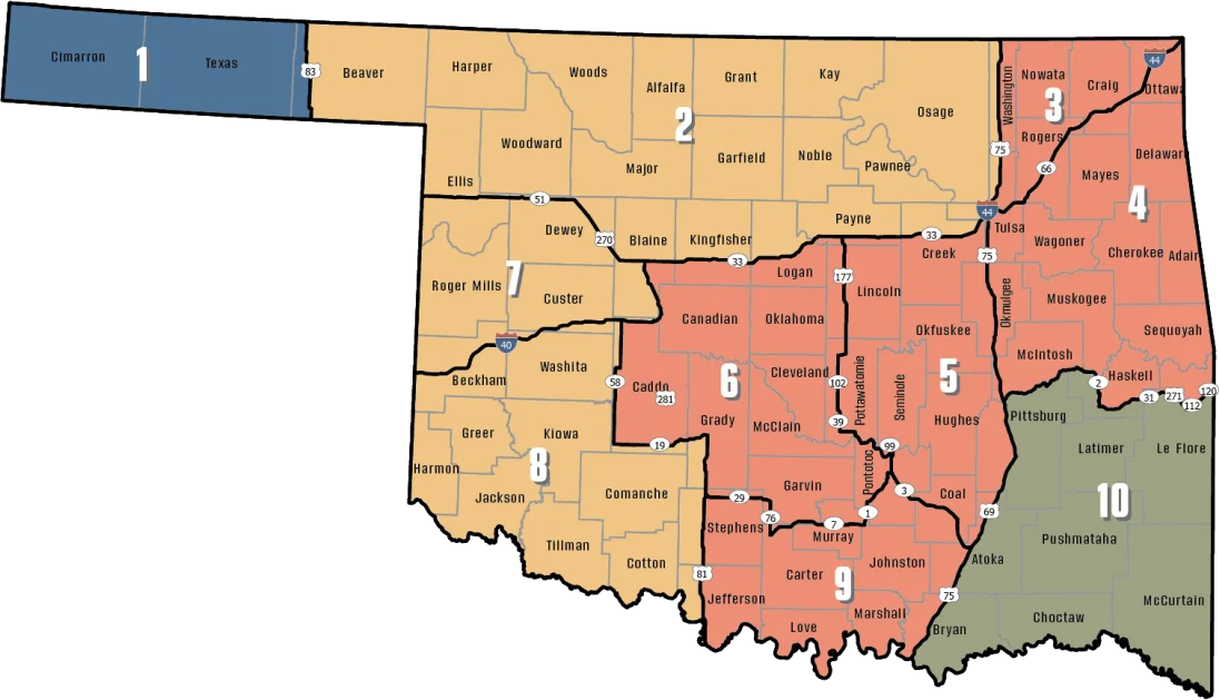
ODWC antlerless deer zones, elk zones, bear area, fall turkey counties, CWD rules; checked November 3, 2026.
Packsaddle WMA rules for 2026-27
ODWC area rules on Packsaddle WMA keep shooting to designated ranges, vehicles to open roads and stands portable. Nonresident check-in applies here; the list entry reads "Packsaddle". Non-hunters on Packsaddle WMA need either a hunting or fishing license or the Wildlife Conservation Passport, $46 resident / $239 nonresident a year. Ducks in the Packsaddle WMA wetland units: mornings only, to 1 p.m., and nontoxic loads.
Area notes for Packsaddle WMA
- All shotgun hunting is restricted to federally approved nontoxic shot on designated WDU portions.
Count it up for Packsaddle WMA: 7 statewide, 15 restricted, 1 closed, out of 23 lines in the ODWC table.
| Hunt | Status | What ODWC adds |
|---|---|---|
| Holiday Antlerless Deer Gun | Closed | – |
| Deer Archery | Statewide dates | – |
| Youth Deer Gun | Statewide dates | – |
| Dove | Statewide dates | – |
| Crow | Statewide dates | – |
| Turkey Fall Archery | Statewide dates | – |
| Rail | Statewide dates | – |
| Gallinule | Statewide dates | – |
| Deer Muzzleloader | Restricted | Closed to antlerless mule deer hunting. |
| Deer Gun | Restricted | Open the first nine days only. Antlerless hunting permitted last two days of area season. |
| Snipe | Restricted | Closed during the first nine days of deer gun season. |
| Woodcock | Restricted | Closed during the first nine days of deer gun season. |
| Rabbit | Restricted | Closed during the first nine days of deer gun season. |
| Squirrel | Restricted | Closed during the first nine days of deer gun season. |
| Predator/Furbearer Calling | Restricted | Closed during the first nine days of deer gun season. |
| Turkey Fall Gun | Restricted | Tom only. Shotgun only. |
| Pursuit with Hounds for Furbearers | Restricted | Closed from the opening day of deer archery season through deer gun season and closed during spring turkey season. |
| Duck, Merganser and Coot | Restricted | Closed during the first nine days of deer gun season. Hunting hours for waterfowl close at 1 p.m. daily on the WDU portion. |
| Sandhill Cranes | Restricted | Closed during the first nine days of deer gun season. Hunting hours for waterfowl close at 1 p.m. daily on the WDU portion. |
| Trapping | Restricted | Open to water sets, live box traps and enclosed trigger traps only through Jan 31. Open same as statewide Feb 1 through end of February. |
| Turkey Spring | Restricted | One-tom limit; seasons combined. Hunting hours close at 7:00 p.m. daily. |
| Youth Turkey Spring | Restricted | One-tom limit; seasons combined. Hunting hours close at 7:00 p.m. daily. |
| Quail | Restricted | Closed during the first nine days of deer gun season. Closed to non-resident hunting February 1-15. |
Extra Packsaddle WMA rules
- Hunter and angler camping is allowed in designated areas during open hunting seasons.
| Area rule | On Packsaddle WMA |
|---|---|
| Bait | Not allowed |
| Stands | Portable only |
| Stand removal | Within 14 days |
| Marking | ODWC customer ID |
| Target shooting | Designated ranges |
| Vehicles | Open roads only |
| Camping limit | 16 days in a row |
- Packsaddle WMA: Bonser Marsh WDU & Designated WDU Areas , Hunting Contact (580) 515-2030
Sources: source, source, source, source (Oklahoma Department of Wildlife Conservation). Checked November 3, 2026.
Harvest figures for Packsaddle WMA
Area harvest, newest season: 105 deer under the name "Packsaddle WMA". Ellis County reported 906 deer in 2025-26 outside WMAs, 563 of them antlered, 65th of 77 counties. By method: 722 gun, 133 archery and 51 muzzleloader. 2025-26 mule deer: 11 in Ellis County.
| Year | Area label | Archery | Muzzleloader | Gun | Sum |
|---|---|---|---|---|---|
| 2024 | Packsaddle WMA | 9 | 10 | 73 | 92 |
| 2025 | Packsaddle WMA | 6 | 16 | 83 | 105 |
ODWC 2025-26 Big Game Harvest Report and earlier ODWC harvest reports (harvest.json); checked November 3, 2026.
Packsaddle WMA season dates, 2026-27
40 species and 61 dated windows reach Packsaddle WMA this year; the right-hand column checks each against today.
| Species | Window | Reach | From | Through | Today? |
|---|---|---|---|---|---|
| White-tailed deer | Archery | Zone 2, 7, 8 | Oct 1, 2026 | Jan 15, 2027 | |
| White-tailed deer | Youth gun | Zone 2, 7, 8 | Oct 16, 2026 | Oct 18, 2026 | |
| White-tailed deer | Muzzleloader | Zone 2, 7, 8 | Oct 24, 2026 | Nov 1, 2026 | |
| White-tailed deer | Gun | Zone 2, 7, 8 | Nov 21, 2026 | Dec 6, 2026 | |
| White-tailed deer | Holiday antlerless | Zone 2, 7, 8 | Dec 18, 2026 | Dec 31, 2026 | |
| Mule deer | All deer seasons | Statewide | Oct 1, 2026 | Jan 15, 2027 | |
| Elk | Archery | Special Northwest elk zone | Oct 1, 2026 | Jan 15, 2027 | |
| Elk | Youth elk gun | Special Northwest elk zone | Oct 16, 2026 | Oct 18, 2026 | |
| Elk | Muzzleloader | Special Northwest elk zone | Oct 24, 2026 | Nov 1, 2026 | |
| Elk | Gun | Special Northwest elk zone | Nov 21, 2026 | Dec 6, 2026 | |
| Elk | Holiday antlerless elk | Special Northwest elk zone | Dec 18, 2026 | Dec 31, 2026 | |
| Wild turkey | Youth fall turkey | Open counties | Oct 16, 2026 | Oct 18, 2026 | |
| Wild turkey | Fall Gun | Open counties | Oct 31, 2026 | Nov 20, 2026 | |
| Wild turkey | Fall Archery | Statewide | Oct 1, 2026 | Jan 15, 2027 | |
| Wild turkey | Youth Spring | Statewide | Apr 10, 2027 | Apr 11, 2027 | |
| Wild turkey | Spring | Statewide | Apr 16, 2027 | May 16, 2027 | |
| Feral hogs | Private land | Private land | Jul 1, 2026 | Jun 30, 2027 | |
| Quail | Season | Statewide | Nov 14, 2026 | Feb 15, 2027 | |
| Pheasant | Season | Pheasant counties | Dec 1, 2026 | Jan 31, 2027 | |
| Rabbits | Season | Statewide | Oct 1, 2026 | Mar 15, 2027 | |
| Jackrabbit | Season | West of I-35 | Oct 1, 2026 | Mar 15, 2027 | |
| Squirrels | Season | Statewide | May 15, 2026 | Feb 28, 2027 | |
| Doves | Segment 1 | Statewide | Sep 1, 2026 | Oct 31, 2026 | |
| Doves | Segment 2 | Statewide | Dec 1, 2026 | Dec 29, 2026 | |
| Teal | September Teal | Statewide | Sep 12, 2026 | Sep 20, 2026 | |
| Ducks | Youth and veteran day | Zones 1 and 2 | Nov 7, 2026 | Nov 7, 2026 | |
| Ducks | Regular segment 1 | Zones 1 and 2 | Nov 14, 2026 | Dec 6, 2026 | |
| Ducks | Regular segment 2 | Zones 1 and 2 | Dec 12, 2026 | Jan 31, 2027 | |
| Ducks | Youth and veteran day | Zones 1 and 2 | Feb 6, 2027 | Feb 6, 2027 | |
| Canada geese | September Canada goose | Statewide | Sep 12, 2026 | Sep 21, 2026 | |
| Dark geese | Segment 1 | Statewide | Nov 7, 2026 | Dec 6, 2026 | |
| Dark geese | Segment 2 | Statewide | Dec 12, 2026 | Feb 14, 2027 | |
| Specklebellies | Segment 1 | Statewide | Nov 7, 2026 | Dec 6, 2026 | |
| Specklebellies | Segment 2 | Statewide | Dec 12, 2026 | Feb 7, 2027 | |
| Light geese | Segment 1 | Statewide | Nov 7, 2026 | Dec 6, 2026 | |
| Light geese | Segment 2 | Statewide | Dec 12, 2026 | Feb 14, 2027 | |
| Light geese | Conservation order | Statewide | Feb 15, 2027 | Mar 30, 2027 | |
| Sandhill crane | Season | West of I-35 | Oct 17, 2026 | Jan 17, 2027 | |
| Woodcock | Season | Statewide | Nov 7, 2026 | Dec 21, 2026 | |
| Coyote | Year-round | Statewide | Jul 1, 2026 | Jun 30, 2027 | |
| Bobcat | Furbearer season | Statewide | Dec 1, 2026 | Feb 28, 2027 | |
| Gray fox | Furbearer season | Statewide | Dec 1, 2026 | Feb 28, 2027 | |
| Red fox | Furbearer season | Statewide | Dec 1, 2026 | Feb 28, 2027 | |
| Raccoon | Year-round | Statewide | Jul 1, 2026 | Jun 30, 2027 | |
| Prairie dog | Year-round | Statewide | Jul 1, 2026 | Jun 30, 2027 | |
| Beaver | Year-round | Statewide | Jul 1, 2026 | Jun 30, 2027 | |
| Nutria | Year-round | Statewide | Jul 1, 2026 | Jun 30, 2027 | |
| Striped skunk | Year-round | Statewide | Jul 1, 2026 | Jun 30, 2027 | |
| Bullfrogs | Year-round | Statewide | Jul 1, 2026 | Jun 30, 2027 | |
| Rails | Season | Statewide | Sep 1, 2026 | Nov 9, 2026 | |
| Gallinules | Season | Statewide | Sep 1, 2026 | Nov 9, 2026 | |
| Snipe | Season | Statewide | Sep 26, 2026 | Jan 10, 2027 | |
| Crows | Segment 1 | Statewide | Oct 10, 2026 | Nov 16, 2026 | |
| River otter | Furbearer season | Statewide | Dec 1, 2026 | Feb 28, 2027 | |
| Badger | Furbearer season | Statewide | Dec 1, 2026 | Feb 28, 2027 | |
| Mink | Furbearer season | Statewide | Dec 1, 2026 | Feb 28, 2027 | |
| Muskrat | Furbearer season | Statewide | Dec 1, 2026 | Feb 28, 2027 | |
| Opossum | Furbearer season | Statewide | Dec 1, 2026 | Feb 28, 2027 | |
| Weasel | Furbearer season | Statewide | Dec 1, 2026 | Feb 28, 2027 | |
| Crows | Segment 2 | Statewide | Dec 9, 2026 | Mar 4, 2027 | |
| Rattlesnakes | Season | Statewide | Mar 1, 2027 | Jun 30, 2027 |
From the ODWC hunting regulations and the 2026-2027 Oklahoma Fishing and Hunting Regulations (Oklahoma Department of Wildlife Conservation), checked November 3, 2026.
Packsaddle WMA and the closest public tracts
Closest non-OLAP ground: Black Kettle National Grassland, 15 mi southwest. Walk-in OLAP ground starts 50 mi off at Woodward OLAP tract H004.
| Area | Type | Acres | County | Straight line | Which way |
|---|---|---|---|---|---|
| Black Kettle National Grassland | National grassland | 30,688 | Roger Mills | 15 mi | southwest |
| Black Kettle WMA | WMA | 30,710 | Roger Mills | 17 mi | southwest |
| Ellis County WMA | WMA | 4,800 | Ellis | 19 mi | northwest |
| Washita NWR | Wildlife refuge | 8,088 | Custer | 29 mi | southeast |
| Dewey County WMA | WMA | 212 | Dewey | 37 mi | east |
| Fort Supply WMA | WMA | 5,462 | Woodward | 43 mi | north |
Points: ODWC Public WMA Boundaries layer (polygon centroid of the largest part). Straight-line distances. Statewide public land map.
Packsaddle WMA: nearest towns, offices and shops
Durham, 15 mi off, is the closest town with a page here. Woodward is the largest of these towns, with 11,750 people in 2024. Other communities nearby: Strong City (15 mi, 29 people) and Leedey (18 mi, 393 people). Warden phones on the area page: (580) 860-4967 (Ellis).
| Town | County | Pop. 2024 | Miles off | Bearing |
|---|---|---|---|---|
| Durham | Roger Mills | – | 15 mi | west |
| Arnett | Ellis | 486 | 19 mi | north |
| Cheyenne | Roger Mills | 736 | 19 mi | south |
| Hammon | Roger Mills | 463 | 23 mi | southeast |
| Woodward | Woodward | 11,750 | 40 mi | north |
Towns from places.json and census_places.json (Census 2024); offices and businesses from services.json; warden numbers from the ODWC area page or warden directory; straight-line miles. Checked November 3, 2026.
Packsaddle Wildlife Management Area: ODWC range details
Packsaddle WMA Shooting Range is on Packsaddle Wildlife Management Area; there is no range fee, but shooters need a hunting or combination license.
From ODWC’s WMA shooting range list and WMA pages, operators’ pages and directory listings, checked November 3, 2026.
Oklahoma views around Packsaddle WMA


Legal hunting times, Packsaddle WMA
Deer, elk, pronghorn, bear and hogs may be hunted from half an hour before official sunrise to half an hour after official sunset; turkey and migratory birds stop at sunset.
| When | Event | Rise | Set | Big game | Birds | Upland |
|---|---|---|---|---|---|---|
| Oct 1, 2026 | Archery deer opens | 7:33 a.m. | 7:24 p.m. | 7:03 a.m. to 7:54 p.m. | 7:03 a.m. to 7:24 p.m. | 7:33 a.m. to 7:24 p.m. |
| Oct 24, 2026 | Muzzleloader opens | 7:53 a.m. | 6:53 p.m. | 7:23 a.m. to 7:23 p.m. | 7:23 a.m. to 6:53 p.m. | 7:53 a.m. to 6:53 p.m. |
| Nov 21, 2026 | Gun deer opens | 7:22 a.m. | 5:29 p.m. | 6:52 a.m. to 5:59 p.m. | 6:52 a.m. to 5:29 p.m. | 7:22 a.m. to 5:29 p.m. |
| Dec 6, 2026 | Gun deer closes | 7:36 a.m. | 5:25 p.m. | 7:06 a.m. to 5:55 p.m. | 7:06 a.m. to 5:25 p.m. | 7:36 a.m. to 5:25 p.m. |
| Dec 21, 2026 | Shortest day | 7:46 a.m. | 5:28 p.m. | 7:16 a.m. to 5:58 p.m. | 7:16 a.m. to 5:28 p.m. | 7:46 a.m. to 5:28 p.m. |
| Jan 15, 2027 | Archery closes | 7:49 a.m. | 5:46 p.m. | 7:19 a.m. to 6:16 p.m. | 7:19 a.m. to 5:46 p.m. | 7:49 a.m. to 5:46 p.m. |
| Apr 16, 2027 | Spring turkey | 7:06 a.m. | 8:12 p.m. | 6:36 a.m. to 8:42 p.m. | 6:36 a.m. to 8:12 p.m. | 7:06 a.m. to 8:12 p.m. |
Hours rules from the ODWC big game regulations and the 2026-2027 Oklahoma Fishing and Hunting Regulations; sunrise and sunset worked out for this location with the NOAA solar formula (Central Time); checked November 3, 2026. Legal hours for every county.
Packsaddle WMA answers from the sources
Is there a place to stay overnight at Packsaddle WMA?
Six designated primitive camping areas are located in the area. Both lodging and restaurants are available 17 miles north in Arnett and 22 miles south in Cheyenne. Shooting Range Features: 100-yard rifle range with 5 covered shooting benches, a trap range, and ADA access and parking. Coordinates : 35.89844 N, 99.67547 W Directions: From Arnett, 17 miles south on U.S.
How many deer were checked from Packsaddle WMA in 2025-26?
105 deer in the 2025-26 report (74 antlered).
What are the archery and gun deer dates at Packsaddle WMA?
Statewide dates: archery from Oct 1, 2026, gun from Nov 21, 2026.
What are the elk rules around Packsaddle WMA?
Public elk hunting is by draw only; county zone: Special Northwest Zone.
Is Packsaddle WMA a large or small piece of ground?
The ODWC area page gives 19,659 acres.
Where would I find Packsaddle WMA on a road map?
Ellis County, in the ODWC Northwest Region. Durham is 15 mi away.
What antlerless limit applies near Packsaddle WMA?
ODWC map overlay: Zone 7 (Muzzleloader 4, gun 4); the legal line is the road on the map. Area rules can narrow it further.
Which documents cover a hunt on Packsaddle WMA?
A state hunting license and species licenses; no separate area permit is listed.
What is there to hunt at Packsaddle WMA?
Game on file: deer, doves, crows, turkey, rails, gallinules, snipe, woodcock, rabbits, squirrels, furbearers, waterfowl, sandhill crane, trapping and quail.
Is feeding game allowed for hunting on Packsaddle WMA?
Not allowed. The Department-Managed Area Rules prohibit bait.
What other public ground lies close to Packsaddle WMA?
Black Kettle National Grassland, about 15 mi southwest.
What agency sets the rules on Packsaddle WMA?
It falls under the Oklahoma Department of Wildlife Conservation. Phone: (580) 515-2030.
Heading to Packsaddle WMA?
Report deer, elk, bear, pronghorn and turkey through E-Check within 24 hours, and carry your field tag while hunting Packsaddle WMA.
Sources: source · source · source · source · source · source; regulations from the 2026-2027 Oklahoma Fishing and Hunting Regulations. Checked November 3, 2026.
Other photos on this page: Cibola National Forest and Grasslands (Public Domain Mark 1.0); Richmassena (English Wikipedia) (CC BY-SA 2.5); Larry Lamsa (CC BY 2.0).