Home › Oklahoma › Towns › Taylor Ferry
Hunting from Wagoner County
Hunting land and seasons near Taylor Ferry, OK
Miles from Taylor Ferry to ODWC wildlife management areas and federal ground, the road-defined deer zone for Wagoner County, the nearest ODWC office and the game warden captain.
Photo: Nearby stand-in for Taylor Ferry: Tenkiller Ferry Lake (U.S. Army Corps of Engineers), 20 mi from Taylor Ferry. usacetulsa (CC BY 2.0)
Taylor Ferry, a Census-designated place, lies in Wagoner County and in the ODWC Northeast Region. Of all towns near Fort Gibson Wildlife Management Area, Taylor Ferry came out closest, with the line under a mile out. Population for Taylor Ferry, a designated place without a charter, is missing from the 2024 series. With overlaps counted once, the 10-mile ring around Taylor Ferry holds about 44,802 mapped public acres (8 listed areas). The wider 25-mile ring adds 7 more areas, for about 120,871 public acres in total. County-wide, Wagoner County counts some 39,233 acres of public ground: 19,748 acres of ODWC area land and 38,932 acres of Corps fee land. Nearest of every listed area is Fort Gibson Lake (Corps), with its closest edge under a mile out.
Town point and land area from the Census 2024 Gazetteer; public acreage and boundary miles within 10 and 25 miles are a GIS measure over the ODWC WMA layer and USFS, USFWS, Corps and NPS boundaries (places.json; area counts are within 25 miles); OLAP tract acres from the ODWC OLAP layer. ODWC region from the ODWC administrative boundaries layer. Checked November 3, 2026.
Nearby
Places to hunt and shoot around Taylor Ferry
Taylor Ferry public land ranked by miles
Miles run from the Taylor Ferry town point to the nearest boundary out to 25 miles, and to the mapped centre beyond; road miles will be longer.
| Property | From town | Type | Run by | Access rule | Acres | Flags |
|---|---|---|---|---|---|---|
| Fort Gibson Lake (Corps) | 0.3 mi NE | Corps lake | Corps | Corps hunting areas | – | No acreage given |
| Fort Gibson PHA | 0.3 mi NW | Public hunting area | ODWC | Area rules | 21,798 | No own boundary |
| Fort Gibson WRP | 0.3 mi SW | Waterfowl refuge portion | ODWC | Closed Oct 15-Jan 31 | 3,500 | Nonresident check-in |
| Fort Gibson WMA base land | 0.3 mi NW | WMA | ODWC | – | 25,298 | Nonresident check-in |
| Chouteau Lock and Dam (Arkansas River) (Corps) | 5.3 mi | Corps lake | Corps | Corps hunting areas | – | No acreage given |
| Webbers Falls Reservoir (Corps) | 5.8 mi | Corps lake | Corps | Corps hunting areas | – | No acreage given |
| McClellan-Kerr WRP | 6.0 mi SW | Waterfowl refuge portion | ODWC | Closed Oct 15-Jan 31 | 250 | No own boundary |
| McClellan-Kerr WMA | 6.0 mi SW | WMA | ODWC | Area rules | 9,366 | Nonresident check-in |
| Cherokee GMA | 14 mi SE | Game management area | ODWC | Area rules | 15,360 | No own boundary |
| Cherokee PHA | 14 mi SE | Public hunting area | ODWC | Area rules | 16,000 | No own boundary |
| Cherokee WMA | 14 mi SE | WMA | ODWC | – | 31,360 | Nonresident check-in |
| Camp Gruber Training Center | 18 mi SE | Military post | Army Guard | UXO permit, set days | 51,840 | Controlled hunts |
| Tenkiller Ferry Lake (Corps) | 20 mi SE | Corps lake | Corps | Corps hunting areas | – | No acreage given |
| Sparrowhawk WMA | 22 mi E | WMA | ODWC | Area rules | 566 | Nonresident check-in |
The biggest single piece of ground here is Camp Gruber Training Center: 51,840 acres. The 25-mile circle mixes 10 ODWC-managed areas, 1 federal area and 4 lake or park areas. Fort Gibson WMA (0.3 mi) is ODWC ground: hunting license, area special regulations and the Department-Managed Area Rules. Visiting hunters need the nonresident check-in at Fort Gibson WMA. Hunting is barred in the developed parks and around the dam at Fort Gibson Lake (Corps); the rest of the Corps hunting land follows state seasons. Fort Gibson WRP closes to all public use from October 15 to January 31, except controlled hunt permittees on their days. Fort Gibson PHA has Wetland Development Units, where waterfowl hunting closes at 1 p.m. and only nontoxic shot is allowed.
What the nearest Taylor Ferry areas offer
- Fort Gibson PHA: 21,798 acres; drive-in acres (permit) 2,282; hunted for deer, dove, turkey, waterfowl, quail; no camping is allowed on the area (ODWC area map)
- Fort Gibson WRP: 3,500 acres; game: dove, waterfowl, quail, squirrel; 2025 deer taken 52; no camping is allowed on the area (map PDF)
- Fort Gibson WMA: 25,298 acres; hunted for deer, dove, turkey, waterfowl, quail; 2025 deer taken 373
Lands from ODWC area pages, Public Hunting Areas special regulations and the OLAP layer, USFWS, USFS, NPS, Corps and installation records (lands.json; each land page cites its own source); 2025 deer harvest by area from the ODWC 2025-26 big game harvest report. Boundary miles from places.json, other miles to each mapped point. Area rules from the Department-Managed Area Rules. Checked November 3, 2026.
County rules that reach Taylor Ferry hunters
Before hunting out of Taylor Ferry, find the county and zone you will stand in; its row sets the limits.
| County | Antlerless | Doe limits | Elk | Fall turkey | Special |
|---|---|---|---|---|---|
| Wagoner County local | 4 | 2/2 | Northeast | Open | – |
| Cherokee County | 4 | 2/2 | Northeast | Open | – |
| Mayes County | 4 | 2/2 | Northeast | Closed | – |
| Muskogee County | 4 | 2/2 | Northeast, Southeast | Open | Bear area (part) |
| Haskell County | 4, 10 | 2/2; 1/1 | Southeast | Open | Bear area |
All of Wagoner County reads as antlerless Zone 4 on the ODWC map, whose lines follow roads rather than county lines. (Zone 4; zone map.) What the zones allow for does: Zone 4: 2 antlerless by muzzleloader and 2 by gun. Across all regular deer seasons the cap is six, including no more than two antlered deer. Bowhunting opens October 1, 2026 and the rifle opener follows on November 21, 2026. Private-land elk hunting near Taylor Ferry follows the Northeast Zone rules, a zone quota of 20 for the Northeast Zone. (Northeast Zone.) Rifles and shotguns may take a fall turkey in Wagoner County from October 31 to November 20. Ducks in Wagoner County follow the shared Zone 1 and 2 dates, November 14 to January 31, 2027 with a December break. East of I-35, including Wagoner County, cranes and jackrabbits may not be hunted. No bait on WMAs or other Department land, and none within 100 yards of a turkey hunter; private-land deer baiting is not banned statewide in the rules read.
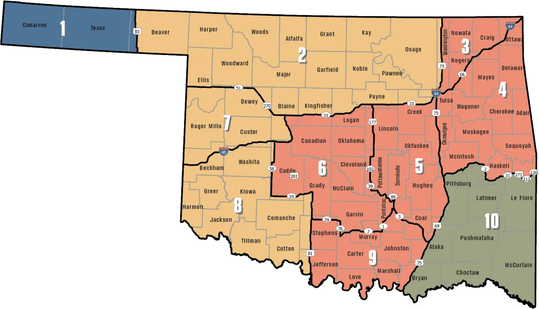
Zones from the ODWC antlerless deer zone map (county shares are a GIS overlay; the legal line is the road), ODWC elk zones, the bear area, fall turkey counties, the pheasant area, waterfowl zones, the crane area and the CWD surveillance areas; limits and baiting from the 2026-2027 Oklahoma Fishing and Hunting Regulations and ODWC turkey regulations. Checked November 3, 2026.
Taylor Ferry harvest numbers from ODWC
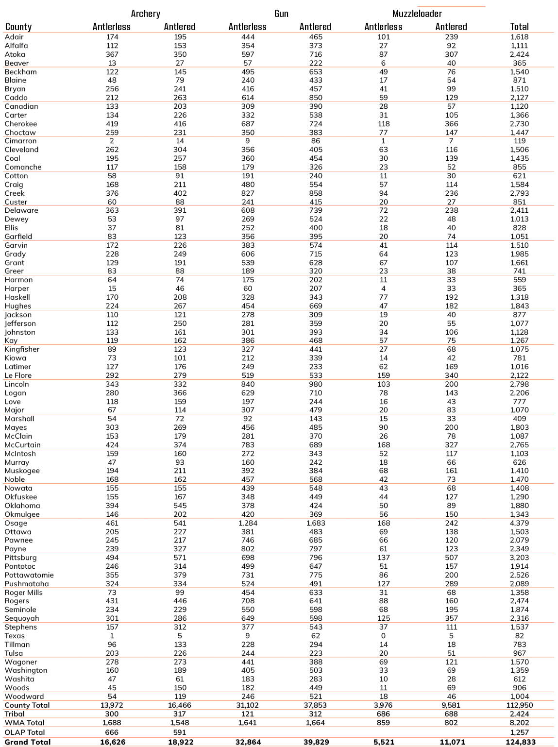
In the 2025 season, 1,812 deer were reported from Wagoner County away from the WMAs. 2024 had 1,756; the change is +3%. Gun hunters accounted for 1,033 of those deer and archers 610. For public-land deer, Fort Gibson WMA topped the 2025 list near Taylor Ferry at 373. There is no county turkey table, only a statewide 2025 spring estimate of 11,232 birds.
| Season | Harvest | Gun | Muzzleloader | Archery | With antlers |
|---|---|---|---|---|---|
| 2021-22 | 1,381 | 728 | 158 | 495 | 730 |
| 2022-23 | 1,842 | 1,039 | 131 | 672 | 898 |
| 2023-24 | 1,570 | 829 | 190 | 551 | 782 |
| 2024-25 | 1,756 | 973 | 123 | 660 | 835 |
| 2025-26 | 1,812 | 1,033 | 169 | 610 | 972 |
| Area | 2024 deer | 2025 deer |
|---|---|---|
| Fort Gibson WRP | – | 52 |
| Fort Gibson WMA | 454 | 373 |
| McClellan-Kerr WMA | 99 | 107 |
County deer harvest from the ODWC big game reports (2021, 2022, 2023, 2024, 2025); area harvest and 2025 elk, bear, mule deer and pronghorn from the 2025-26 big game harvest report; turkey from the ODWC Game Harvest Survey. Checked November 3, 2026.
Taylor Ferry dates from archery to spring turkey
For Wagoner County the list holds 58 seasons for 2026-27: big game, turkey, upland birds, small game, waterfowl and predators.
| Animal | Season type | Where | Start | Finish | Right now |
|---|---|---|---|---|---|
| White-tailed deer | Archery | Zone 3, 4, 5, 6, 9 | Oct 1, 2026 | Jan 15, 2027 | |
| White-tailed deer | Youth gun | Zone 3, 4, 5, 6, 9 | Oct 16, 2026 | Oct 18, 2026 | |
| White-tailed deer | Muzzleloader | Zone 3, 4, 5, 6, 9 | Oct 24, 2026 | Nov 1, 2026 | |
| White-tailed deer | Gun | Zone 3, 4, 5, 6, 9 | Nov 21, 2026 | Dec 6, 2026 | |
| White-tailed deer | Holiday antlerless | Zone 3, 4, 5, 6, 9 | Dec 18, 2026 | Dec 31, 2026 | |
| Mule deer | All deer seasons | Statewide | Oct 1, 2026 | Jan 15, 2027 | |
| Elk | Archery | Northeast elk zone | Oct 1, 2026 | Jan 15, 2027 | |
| Elk | Youth elk gun | Northeast elk zone | Oct 16, 2026 | Oct 18, 2026 | |
| Elk | Muzzleloader | Northeast elk zone | Oct 24, 2026 | Nov 1, 2026 | |
| Elk | Gun | Northeast elk zone | Nov 21, 2026 | Dec 6, 2026 | |
| Elk | Holiday antlerless elk | Northeast elk zone | Dec 18, 2026 | Dec 31, 2026 | |
| Wild turkey | Youth fall turkey | Open counties | Oct 16, 2026 | Oct 18, 2026 | |
| Wild turkey | Fall Gun | Open counties | Oct 31, 2026 | Nov 20, 2026 | |
| Wild turkey | Fall Archery | Statewide | Oct 1, 2026 | Jan 15, 2027 | |
| Wild turkey | Youth Spring | Statewide | Apr 10, 2027 | Apr 11, 2027 | |
| Wild turkey | Spring | Statewide | Apr 16, 2027 | May 16, 2027 | |
| Feral hogs | Private land | Private land | Jul 1, 2026 | Jun 30, 2027 | |
| Quail | Season | Statewide | Nov 14, 2026 | Feb 15, 2027 | |
| Rabbits | Season | Statewide | Oct 1, 2026 | Mar 15, 2027 | |
| Squirrels | Season | Statewide | May 15, 2026 | Feb 28, 2027 | |
| Doves | Segment 1 | Statewide | Sep 1, 2026 | Oct 31, 2026 | |
| Doves | Segment 2 | Statewide | Dec 1, 2026 | Dec 29, 2026 | |
| Teal | September Teal | Statewide | Sep 12, 2026 | Sep 20, 2026 | |
| Ducks | Youth and veteran day | Zones 1 and 2 | Nov 7, 2026 | Nov 7, 2026 | |
| Ducks | Regular segment 1 | Zones 1 and 2 | Nov 14, 2026 | Dec 6, 2026 | |
| Ducks | Regular segment 2 | Zones 1 and 2 | Dec 12, 2026 | Jan 31, 2027 | |
| Ducks | Youth and veteran day | Zones 1 and 2 | Feb 6, 2027 | Feb 6, 2027 | |
| Canada geese | September Canada goose | Statewide | Sep 12, 2026 | Sep 21, 2026 | |
| Dark geese | Segment 1 | Statewide | Nov 7, 2026 | Dec 6, 2026 | |
| Dark geese | Segment 2 | Statewide | Dec 12, 2026 | Feb 14, 2027 | |
| Specklebellies | Segment 1 | Statewide | Nov 7, 2026 | Dec 6, 2026 | |
| Specklebellies | Segment 2 | Statewide | Dec 12, 2026 | Feb 7, 2027 | |
| Light geese | Segment 1 | Statewide | Nov 7, 2026 | Dec 6, 2026 | |
| Light geese | Segment 2 | Statewide | Dec 12, 2026 | Feb 14, 2027 | |
| Light geese | Conservation order | Statewide | Feb 15, 2027 | Mar 30, 2027 | |
| Woodcock | Season | Statewide | Nov 7, 2026 | Dec 21, 2026 | |
| Coyote | Year-round | Statewide | Jul 1, 2026 | Jun 30, 2027 | |
| Bobcat | Furbearer season | Statewide | Dec 1, 2026 | Feb 28, 2027 | |
| Gray fox | Furbearer season | Statewide | Dec 1, 2026 | Feb 28, 2027 | |
| Red fox | Furbearer season | Statewide | Dec 1, 2026 | Feb 28, 2027 | |
| Raccoon | Year-round | Statewide | Jul 1, 2026 | Jun 30, 2027 | |
| Prairie dog | Year-round | Statewide | Jul 1, 2026 | Jun 30, 2027 | |
| Beaver | Year-round | Statewide | Jul 1, 2026 | Jun 30, 2027 | |
| Nutria | Year-round | Statewide | Jul 1, 2026 | Jun 30, 2027 | |
| Striped skunk | Year-round | Statewide | Jul 1, 2026 | Jun 30, 2027 | |
| Bullfrogs | Year-round | Statewide | Jul 1, 2026 | Jun 30, 2027 | |
| Rails | Season | Statewide | Sep 1, 2026 | Nov 9, 2026 | |
| Gallinules | Season | Statewide | Sep 1, 2026 | Nov 9, 2026 | |
| Snipe | Season | Statewide | Sep 26, 2026 | Jan 10, 2027 | |
| Crows | Segment 1 | Statewide | Oct 10, 2026 | Nov 16, 2026 | |
| River otter | Furbearer season | Statewide | Dec 1, 2026 | Feb 28, 2027 | |
| Badger | Furbearer season | Statewide | Dec 1, 2026 | Feb 28, 2027 | |
| Mink | Furbearer season | Statewide | Dec 1, 2026 | Feb 28, 2027 | |
| Muskrat | Furbearer season | Statewide | Dec 1, 2026 | Feb 28, 2027 | |
| Opossum | Furbearer season | Statewide | Dec 1, 2026 | Feb 28, 2027 | |
| Weasel | Furbearer season | Statewide | Dec 1, 2026 | Feb 28, 2027 | |
| Crows | Segment 2 | Statewide | Dec 9, 2026 | Mar 4, 2027 | |
| Rattlesnakes | Season | Statewide | Mar 1, 2027 | Jun 30, 2027 |
From the ODWC hunting regulations and the 2026-2027 Oklahoma Fishing and Hunting Regulations (Oklahoma Department of Wildlife Conservation), checked November 3, 2026.
Controlled hunts near Taylor Ferry
Fort Gibson WRP is the nearest of 6 controlled-hunt areas around Taylor Ferry. Entries for 2026 controlled hunts were due May 20, 2026. No-shows are not refilled and fees are not refunded, so apply only for dates you can hunt.
| Area | Miles | Kind | 2025 hunts | Permits |
|---|---|---|---|---|
| Fort Gibson WRP | 1.7 mi | Waterfowl refuge portion | Deer, Motor vehicle or non-ambulatory permit deer, Youth dee | 205 |
| Camp Gruber Training Center | 18 mi | Military post | Elk, Youth deer | 41 |
| Cherokee GMA | 20 mi | Game management area | Deer, Elk, Motor vehicle or non-ambulatory permit deer, Yout | 211 |
| Tenkiller Ferry Lake (Corps) | 25 mi | Corps lake | Youth deer | 10 |
| Cookson WMA | 32 mi | WMA | Deer, Elk, Motor vehicle or non-ambulatory permit deer, Yout | 67 |
| Spavinaw GMA | 35 mi | Game management area | Deer, Youth deer | 100 |
2025 controlled hunt results per area from the ODWC controlled hunts results (lands.json, controlled_hunts_2025); rules and dates from the ODWC controlled hunts page. Checked November 3, 2026.
Processing, mounts and gear near Taylor Ferry
ODWC licenses commercial hunting areas but keeps no hunting guide list, so the guide rows are preserves and directory listings. To give venison to food banks, Jenkins Wild Game Processing (9.7 mi) is a Hunters Against Hunger processor. First taxidermy stop: McDaris Taxidermy & Gun (Wagoner), 4.9 mi from Taylor Ferry. For gear, the first store listed is Loco Smiths Firearms Inc. in Wagoner. Gordie's Wildlife, Inc. in Inola is the commercial hunting option nearest Taylor Ferry.
| Service | Close (15 mi) | Wider (35 mi) | Closest | Miles | City |
|---|---|---|---|---|---|
| Game processors | 3 | 12 | Jenkins Wild Game Processing | 9.7 mi SW | Porter |
| Taxidermy shops | 1 | 11 | McDaris Taxidermy & Gun | 4.9 mi NW | Wagoner |
| Sporting goods | 5 | 28 | Loco Smiths Firearms Inc. | 3.7 mi NW | Wagoner |
| Outfitters and preserves | 0 | 2 | Gordie's Wildlife, Inc. | 18 mi NW | Inola |
Game processors
Taxidermy shops
Sporting goods
Outfitters and preserves
Processors from the ODWC game processor list (Hunters Against Hunger column) and Yellow Pages; commercial hunting areas from the ODWC commercial hunt area list; taxidermists and shops from Yellow Pages and chain store locators (services.json). Listings without coordinates are placed at their town. Checked November 3, 2026; hours were not checked.
Taylor Ferry and its surroundings, event dates
A crow-flight ring of roughly 30 miles takes in 14 upcoming listings, covering DU bingo night, DU chapter dinner, NWTF banquet, NWTF bingo fundraiser, NWTF women’s mentored hunt, ODWC controlled hunt, ODWC youth draw and RMEF chapter banquet. The 7 controlled hunts here were filled by the ODWC random drawing that closed in May.
Next on the list
Taylor Ferry shooters: the three nearest ranges
The three ranges nearest Taylor Ferry, measured in a straight line.
Straight-line miles from the town centre; ranges checked November 3, 2026.
Taylor Ferry legal shooting light
Squirrel, rabbit and prairie dog hours run from half an hour before sunrise to sunset in Taylor Ferry.
| When | Event | Rise | Set | Big game | Birds | Upland |
|---|---|---|---|---|---|---|
| Oct 1, 2026 | Archery deer opens | 7:16 a.m. | 7:07 p.m. | 6:46 a.m.–7:37 p.m. | 6:46 a.m.–7:07 p.m. | 7:16 a.m.–7:07 p.m. |
| Oct 24, 2026 | Muzzleloader opens | 7:36 a.m. | 6:36 p.m. | 7:06 a.m.–7:06 p.m. | 7:06 a.m.–6:36 p.m. | 7:36 a.m.–6:36 p.m. |
| Nov 21, 2026 | Gun deer opens | 7:04 a.m. | 5:12 p.m. | 6:34 a.m.–5:42 p.m. | 6:34 a.m.–5:12 p.m. | 7:04 a.m.–5:12 p.m. |
| Dec 6, 2026 | Gun deer closes | 7:18 a.m. | 5:08 p.m. | 6:48 a.m.–5:38 p.m. | 6:48 a.m.–5:08 p.m. | 7:18 a.m.–5:08 p.m. |
| Dec 21, 2026 | Shortest day | 7:28 a.m. | 5:11 p.m. | 6:58 a.m.–5:41 p.m. | 6:58 a.m.–5:11 p.m. | 7:28 a.m.–5:11 p.m. |
| Jan 15, 2027 | Archery closes | 7:32 a.m. | 5:30 p.m. | 7:02 a.m.–6:00 p.m. | 7:02 a.m.–5:30 p.m. | 7:32 a.m.–5:30 p.m. |
| Apr 16, 2027 | Spring turkey | 6:49 a.m. | 7:55 p.m. | 6:19 a.m.–8:25 p.m. | 6:19 a.m.–7:55 p.m. | 6:49 a.m.–7:55 p.m. |
Hours rules from the ODWC big game regulations and the 2026-2027 Oklahoma Fishing and Hunting Regulations; sunrise and sunset worked out for this location with the NOAA solar formula (Central Time); checked November 3, 2026. Legal hours for every county.
ODWC help nearest Taylor Ferry
From Taylor Ferry, the nearest ODWC office is in Porter, about 13 miles off. Matt Mattioda supervises wildlife work for the Northeast Region, including Wagoner County. The game warden captain for District 2, which includes Wagoner County, is David Robertson. Warden numbers printed for Wagoner County: (918) 625-5796 and (918) 625-5085. For the Commission, Wagoner County belongs to District 2.
ODWC at Porter
ODWC office, Miami
Offices from the ODWC offices list, game warden districts and captains from the ODWC game warden directory, region supervisors from the ODWC administrative boundaries layer, county warden phones from ODWC area pages (counties.json, services.json, lands.json). Offices without a geocoded address are measured to their town. Checked November 3, 2026.
Taylor Ferry hunting questions
Do riders on a WMA near Taylor Ferry need orange?
Yes. Horse riders on WMAs during deer muzzleloader and gun seasons need 400 square inches of orange.
Is there an elk quota in Wagoner County?
The Northeast Zone has a quota of 20.
May I hunt deer over corn near Taylor Ferry?
On private land the 2026-27 rules read set no statewide ban; on ODWC land baiting is illegal.
What goes on a field tag for a deer shot near Taylor Ferry?
Your name, customer ID number, and the date and time of harvest.
When are OLAP tracts open?
September 1 to May 16, from two hours before sunrise to one hour after sunset.
Is there a Sunday hunting law in Oklahoma?
No Sunday restriction was found in the 2026-27 rules.
Who is the game warden captain for Taylor Ferry?
David Robertson, captain of District 2, (918) 431-2543.
How long is the haul from Taylor Ferry to a game processor?
About 9.7 mi, to Jenkins Wild Game Processing in Porter.
Name the WMA, OLAP tract or federal area nearest to Taylor Ferry.
Closest of all: Fort Gibson Lake (Corps), with its closest edge under a mile out. One step farther lies Fort Gibson PHA, with its closest edge under a mile out.
What other base towns are close to Taylor Ferry?
Wagoner is closest, then Okay, Mallard Bay and Fort Gibson.
Which ODWC antlerless zone covers Wagoner County?
Zone 4.
Is Taylor Ferry a good base for Oklahoma public-land hunting?
It has 8 listed areas inside 10 miles, with about 44,802 mapped public acres.
On what date does gun deer season end near Taylor Ferry?
December 6, 2026, with the holiday antlerless season later in December.
Answers from places.json, lands.json, counties.json, services.json and the 2026-2027 Oklahoma Fishing and Hunting Regulations; reporting from ODWC, hunter orange from the ODWC big game regulations, baiting from ODWC, Sunday hunting from ODWC seasons, the Land Access Permit from the ODWC license fees, CWD from ODWC. Checked November 3, 2026.
Taylor Ferry pre-trip checks
For hunts out of Taylor Ferry, the special regulations on each land page and the ODWC regulations settle any doubt.
Other photos on this page: Thomas & Dianne Jones (CC BY 2.0); Thesagemarmot (CC BY-SA 3.0); Kool Cats Photography (CC BY 2.0); Guy Teague (CC BY-SA 2.0); Pondfishfarmer (CC BY-SA 4.0); Shiva Shenoy (CC BY 4.0); U.S. Fish & Wildlife Service Southwest Region (Public Domain Mark 1.0); Jack Gray (CC BY 2.0).