Home › Oklahoma › Public land › Kay OLAP tract H020
Public ground · OLAP walk-in
Kay County OLAP Walk-In Hunting Area H020
A 2026-27 guide to the OLAP walk-in tract, 481 acres, in Kay County.
Photo: Phil Fox (CC BY-SA 2.0)
Getting to Kay County OLAP Walk-In Hunting Area H020
Parking, trailheads and gates near Kay County OLAP Walk-In Hunting Area H020
- Parking areaParking · 3.2 mi from the centreDirections
- Parking areaParking · 3.2 mi from the centreDirections
- Parking areaParking · 3.3 mi from the centreDirections
- Parking areaParking · 3.3 mi from the centreDirections
- Parking areaParking · 3.3 mi from the centreDirections
- Parking areaParking · 3.3 mi from the centreDirections
- Parking areaParking · 3.3 mi from the centreDirections
- Parking areaParking · 3.3 mi from the centreDirections
- Parking areaParking · 3.3 mi from the centreDirections
- Parking areaParking · 3.3 mi from the centreDirections
- Parking areaParking · 3.3 mi from the centreDirections
- Parking areaParking · 3.3 mi from the centreDirections
Parking, trailhead and gate locations come from OpenStreetMap contributors. Roads into public land can be gated or seasonal; check with the managing agency before you go.
The Kay OLAP tract H020 record
Private land, public access: the 481 acres of Kay OLAP tract H020 are enrolled in OLAP by their owner. Size rank in the county: 1st of 6 tracts, which together cover 1,176 acres. ODWC gives no habitat description for it. Listed game: deer, dove, waterfowl and turkey. Map measurement: 486 acres.
| Field | OLAP layer |
|---|---|
| OLAP ID | Kay_H020 |
| Acres (layer) | 481 |
| GIS acres | 486 |
| Cover | – |
| Season | Sept. 1 to May 16 |
| County | Kay County |
| County rank | 1 of 6 |
| PATH tract | No |
From the ODWC OLAP layer (OLAP_UpdatedLayers_062626); checked November 3, 2026.
Nearby
Places to hunt and shoot around Kay County OLAP Walk-In Hunting Area H020
Zones and county rules around Kay OLAP tract H020
| Topic | Kay County |
|---|---|
| Antlerless zone | 2 |
| Elk zone | Northwest, Northeast |
| Bear area | No |
| Pronghorn | No season |
| Fall gun turkey | Open |
| Pheasant | Whole county |
| Duck dates | Zones 1 and 2 |
| Crane, jackrabbit | West of I-35 |
| CWD surveillance | Outside |
| ODWC region | Central |
| Warden district | No. 8 |
Overlaying the ODWC antlerless zone map on the boundary gives Zone 2 (Muzzleloader 4, gun 4); roads, not county lines, divide the zones. Deer limits: six total for the season, two antlered maximum, in every zone. OLAP closes elk season on Kay OLAP tract H020, although Kay County lies in the Northwest Zone and Northeast Zone for private land elsewhere. The fall gun turkey list includes Kay County. Kay County is pheasant country (the whole county). Kay County counts as west of I-35 for crane and jackrabbit.
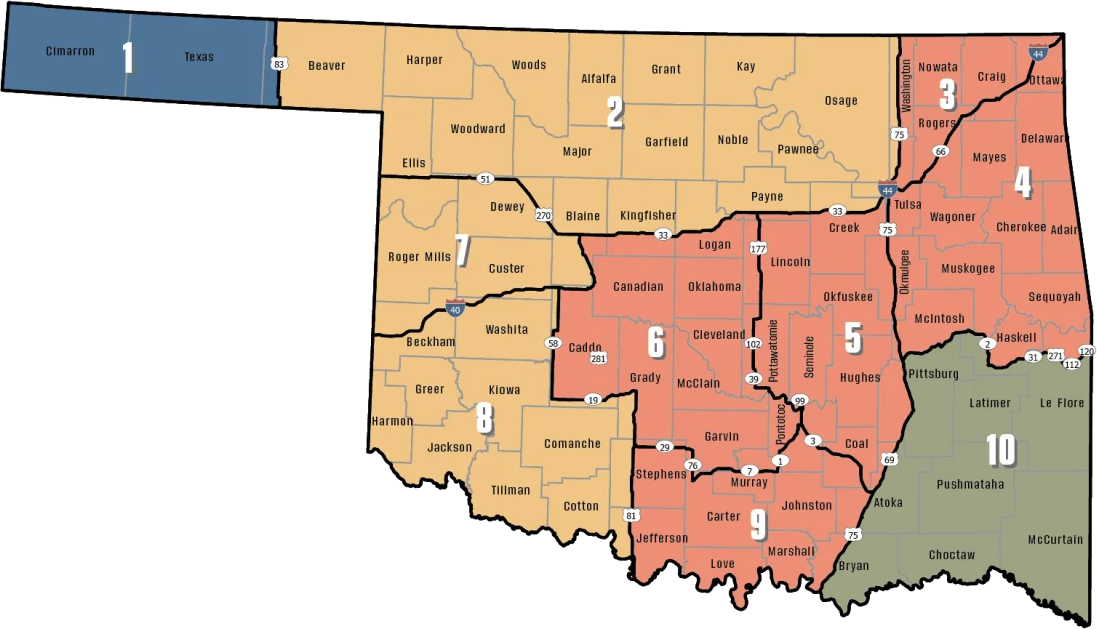
ODWC antlerless deer zones, elk zones, bear area, fall turkey counties, CWD rules; checked November 3, 2026.
Kay OLAP tract H020 OLAP requirements
| OLAP rule | Detail |
|---|---|
| Permit | Land Access Permit |
| Fee | $100 / $200 |
| Weapons | Archery, shotgun |
| Largest shot | T |
| Access | Foot only |
| Open | Sept. 1 to May 16 |
| Quail, pheasant | End 4:30 p.m. |
| Elk | Closed |
| Camping | Not allowed |
Expect to show a Land Access Permit on Kay OLAP tract H020; it runs $100 resident / $200 nonresident, with an age exemption for young and senior residents only. Only archery gear and shotguns are legal here; rifles, muzzleloaders and slugs are banned, and no shot larger than T. Foot traffic only, and only between two hours before sunrise and an hour past sunset. Stop shooting quail and pheasant at 4:30 p.m. on any OLAP tract. Elk hunting is not allowed on OLAP, and there is no camping, fire or alcohol. Trapping is allowed only with water sets, box traps or enclosed-trigger traps.
Sources: ODWC OLAP layer, OLAP hunting regulations, OLAP program page, license fees. Checked November 3, 2026.
Deer harvest around Kay OLAP tract H020
Kay County reported 1,325 deer in 2025-26 outside WMAs, 703 of them antlered, 44th of 77 counties. By method: 940 gun, 259 archery and 126 muzzleloader.
ODWC 2025-26 Big Game Harvest Report and earlier ODWC harvest reports (harvest.json); checked November 3, 2026.
Kay OLAP tract H020 season dates, 2026-27
40 species and 66 dated windows reach Kay OLAP tract H020 this year; the right-hand column checks each against today.
| Species | Window | Reach | From | Through | Today? |
|---|---|---|---|---|---|
| White-tailed deer | Archery | Zone 2, 7, 8 | Oct 1, 2026 | Jan 15, 2027 | |
| White-tailed deer | Youth gun | Zone 2, 7, 8 | Oct 16, 2026 | Oct 18, 2026 | |
| White-tailed deer | Muzzleloader | Zone 2, 7, 8 | Oct 24, 2026 | Nov 1, 2026 | |
| White-tailed deer | Gun | Zone 2, 7, 8 | Nov 21, 2026 | Dec 6, 2026 | |
| White-tailed deer | Holiday antlerless | Zone 2, 7, 8 | Dec 18, 2026 | Dec 31, 2026 | |
| Mule deer | All deer seasons | Statewide | Oct 1, 2026 | Jan 15, 2027 | |
| Elk | Archery | Northeast elk zone | Oct 1, 2026 | Jan 15, 2027 | |
| Elk | Youth elk gun | Northeast elk zone | Oct 16, 2026 | Oct 18, 2026 | |
| Elk | Muzzleloader | Northeast elk zone | Oct 24, 2026 | Nov 1, 2026 | |
| Elk | Gun | Northeast elk zone | Nov 21, 2026 | Dec 6, 2026 | |
| Elk | Holiday antlerless elk | Northeast elk zone | Dec 18, 2026 | Dec 31, 2026 | |
| Elk | Archery | Northwest elk zone | Oct 1, 2026 | Jan 15, 2027 | |
| Elk | Youth elk gun | Northwest elk zone | Oct 16, 2026 | Oct 18, 2026 | |
| Elk | Muzzleloader | Northwest elk zone | Oct 24, 2026 | Nov 1, 2026 | |
| Elk | Gun | Northwest elk zone | Nov 21, 2026 | Dec 6, 2026 | |
| Elk | Holiday antlerless elk | Northwest elk zone | Dec 18, 2026 | Dec 31, 2026 | |
| Wild turkey | Youth fall turkey | Open counties | Oct 16, 2026 | Oct 18, 2026 | |
| Wild turkey | Fall Gun | Open counties | Oct 31, 2026 | Nov 20, 2026 | |
| Wild turkey | Fall Archery | Statewide | Oct 1, 2026 | Jan 15, 2027 | |
| Wild turkey | Youth Spring | Statewide | Apr 10, 2027 | Apr 11, 2027 | |
| Wild turkey | Spring | Statewide | Apr 16, 2027 | May 16, 2027 | |
| Feral hogs | Private land | Private land | Jul 1, 2026 | Jun 30, 2027 | |
| Quail | Season | Statewide | Nov 14, 2026 | Feb 15, 2027 | |
| Pheasant | Season | Pheasant counties | Dec 1, 2026 | Jan 31, 2027 | |
| Rabbits | Season | Statewide | Oct 1, 2026 | Mar 15, 2027 | |
| Jackrabbit | Season | West of I-35 | Oct 1, 2026 | Mar 15, 2027 | |
| Squirrels | Season | Statewide | May 15, 2026 | Feb 28, 2027 | |
| Doves | Segment 1 | Statewide | Sep 1, 2026 | Oct 31, 2026 | |
| Doves | Segment 2 | Statewide | Dec 1, 2026 | Dec 29, 2026 | |
| Teal | September Teal | Statewide | Sep 12, 2026 | Sep 20, 2026 | |
| Ducks | Youth and veteran day | Zones 1 and 2 | Nov 7, 2026 | Nov 7, 2026 | |
| Ducks | Regular segment 1 | Zones 1 and 2 | Nov 14, 2026 | Dec 6, 2026 | |
| Ducks | Regular segment 2 | Zones 1 and 2 | Dec 12, 2026 | Jan 31, 2027 | |
| Ducks | Youth and veteran day | Zones 1 and 2 | Feb 6, 2027 | Feb 6, 2027 | |
| Canada geese | September Canada goose | Statewide | Sep 12, 2026 | Sep 21, 2026 | |
| Dark geese | Segment 1 | Statewide | Nov 7, 2026 | Dec 6, 2026 | |
| Dark geese | Segment 2 | Statewide | Dec 12, 2026 | Feb 14, 2027 | |
| Specklebellies | Segment 1 | Statewide | Nov 7, 2026 | Dec 6, 2026 | |
| Specklebellies | Segment 2 | Statewide | Dec 12, 2026 | Feb 7, 2027 | |
| Light geese | Segment 1 | Statewide | Nov 7, 2026 | Dec 6, 2026 | |
| Light geese | Segment 2 | Statewide | Dec 12, 2026 | Feb 14, 2027 | |
| Light geese | Conservation order | Statewide | Feb 15, 2027 | Mar 30, 2027 | |
| Sandhill crane | Season | West of I-35 | Oct 17, 2026 | Jan 17, 2027 | |
| Woodcock | Season | Statewide | Nov 7, 2026 | Dec 21, 2026 | |
| Coyote | Year-round | Statewide | Jul 1, 2026 | Jun 30, 2027 | |
| Bobcat | Furbearer season | Statewide | Dec 1, 2026 | Feb 28, 2027 | |
| Gray fox | Furbearer season | Statewide | Dec 1, 2026 | Feb 28, 2027 | |
| Red fox | Furbearer season | Statewide | Dec 1, 2026 | Feb 28, 2027 | |
| Raccoon | Year-round | Statewide | Jul 1, 2026 | Jun 30, 2027 | |
| Prairie dog | Year-round | Statewide | Jul 1, 2026 | Jun 30, 2027 | |
| Beaver | Year-round | Statewide | Jul 1, 2026 | Jun 30, 2027 | |
| Nutria | Year-round | Statewide | Jul 1, 2026 | Jun 30, 2027 | |
| Striped skunk | Year-round | Statewide | Jul 1, 2026 | Jun 30, 2027 | |
| Bullfrogs | Year-round | Statewide | Jul 1, 2026 | Jun 30, 2027 | |
| Rails | Season | Statewide | Sep 1, 2026 | Nov 9, 2026 | |
| Gallinules | Season | Statewide | Sep 1, 2026 | Nov 9, 2026 | |
| Snipe | Season | Statewide | Sep 26, 2026 | Jan 10, 2027 | |
| Crows | Segment 1 | Statewide | Oct 10, 2026 | Nov 16, 2026 | |
| River otter | Furbearer season | Statewide | Dec 1, 2026 | Feb 28, 2027 | |
| Badger | Furbearer season | Statewide | Dec 1, 2026 | Feb 28, 2027 | |
| Mink | Furbearer season | Statewide | Dec 1, 2026 | Feb 28, 2027 | |
| Muskrat | Furbearer season | Statewide | Dec 1, 2026 | Feb 28, 2027 | |
| Opossum | Furbearer season | Statewide | Dec 1, 2026 | Feb 28, 2027 | |
| Weasel | Furbearer season | Statewide | Dec 1, 2026 | Feb 28, 2027 | |
| Crows | Segment 2 | Statewide | Dec 9, 2026 | Mar 4, 2027 | |
| Rattlesnakes | Season | Statewide | Mar 1, 2027 | Jun 30, 2027 |
From the ODWC hunting regulations and the 2026-2027 Oklahoma Fishing and Hunting Regulations (Oklahoma Department of Wildlife Conservation), checked November 3, 2026.
Other public land a short drive from Kay OLAP tract H020
Closest non-OLAP ground: Kaw Lake (Corps), 21 mi east. Another OLAP tract, Kay OLAP limited access LA001, is 0.4 mi north.
| Area | Type | Acres | County | Straight line | Which way |
|---|---|---|---|---|---|
| Kaw Lake (Corps) | Corps lake | – | Kay, Osage | 21 mi | east |
| Kaw WMA | WMA | 17,450 | Kay, Osage | 22 mi | northeast |
| John Dahl WMA | WMA | 480 | Osage | 41 mi | east |
| Drummond Flats WMA | WMA | 5,122 | Garfield | 53 mi | southwest |
| Osage WMA | WMA | 11,051 | Osage | 53 mi | east |
| Osage WMA Western Wall Unit (7,329 acres) | WMA unit | 7,329 | Osage | 53 mi | east |
OLAP tracts near Kay OLAP tract H020
| Area | Type | Acres | County | Straight line | Which way |
|---|---|---|---|---|---|
| Kay OLAP limited access LA001 | OLAP limited access | 55 | Kay | 0.4 mi | north |
| Kay OLAP tract H021 | OLAP walk-in | 240 | Kay | 2.2 mi | southeast |
| Kay OLAP tract H023 | OLAP walk-in | 160 | Kay | 4.6 mi | northeast |
| Kay OLAP tract H024 | OLAP walk-in | 80 | Kay | 10 mi | southwest |
Points: ODWC OLAP Walk-In Access layer (tract polygon) (polygon centroid). Straight-line distances. Statewide public land map.
Towns within reach of Kay OLAP tract H020
The nearest town page is Newkirk, 17 mi from Kay OLAP tract H020. Perry is the largest of these towns, with 4,448 people in 2024. Other communities nearby: Tonkawa Tribal Housing (1.8 mi) and Tonkawa (4.4 mi, 2,988 people). Kay County is in game warden District 8; the district captain is Ben Bickerstaff, (580) 304-6034.
| Town | County | Pop. 2024 | Miles off | Bearing |
|---|---|---|---|---|
| Newkirk | Kay | 2,243 | 17 mi | northeast |
| Kaw City | Kay | 327 | 22 mi | east |
| Perry | Noble | 4,448 | 28 mi | south |
| Medford | Grant | 915 | 29 mi | west |
| Pawnee | Pawnee | 1,971 | 33 mi | southeast |
Towns from places.json and census_places.json (Census 2024); offices and businesses from services.json; warden numbers from the ODWC area page or warden directory; straight-line miles. Checked November 3, 2026.
Kay County OLAP Walk-In Hunting Area H020 hunters: free WMA line plus clubs
Kaw WMA Shooting Range is 22 miles from Kay County OLAP Walk-In Hunting Area H020 and is the free WMA line closest to it. Two private or club ranges inside 30 miles complete the row.
From ODWC’s WMA shooting range list and WMA pages, operators’ pages and directory listings, checked November 3, 2026.
When legal light begins in Kay OLAP tract H020
Deer, elk, pronghorn, bear and hogs may be hunted from half an hour before official sunrise to half an hour after official sunset; turkey and migratory birds stop at sunset.
| When | Event | Rise | Set | Big game | Birds | Upland |
|---|---|---|---|---|---|---|
| Oct 1, 2026 | Archery deer opens | 7:23 a.m. | 7:14 p.m. | 6:53 a.m. to 7:44 p.m. | 6:53 a.m. to 7:14 p.m. | 7:23 a.m. to 7:14 p.m. |
| Oct 24, 2026 | Muzzleloader opens | 7:43 a.m. | 6:42 p.m. | 7:13 a.m. to 7:12 p.m. | 7:13 a.m. to 6:42 p.m. | 7:43 a.m. to 6:42 p.m. |
| Nov 21, 2026 | Gun deer opens | 7:13 a.m. | 5:17 p.m. | 6:43 a.m. to 5:47 p.m. | 6:43 a.m. to 5:17 p.m. | 7:13 a.m. to 5:17 p.m. |
| Dec 6, 2026 | Gun deer closes | 7:27 a.m. | 5:13 p.m. | 6:57 a.m. to 5:43 p.m. | 6:57 a.m. to 5:13 p.m. | 7:27 a.m. to 5:13 p.m. |
| Dec 21, 2026 | Shortest day | 7:37 a.m. | 5:16 p.m. | 7:07 a.m. to 5:46 p.m. | 7:07 a.m. to 5:16 p.m. | 7:37 a.m. to 5:16 p.m. |
| Jan 15, 2027 | Archery closes | 7:40 a.m. | 5:34 p.m. | 7:10 a.m. to 6:04 p.m. | 7:10 a.m. to 5:34 p.m. | 7:40 a.m. to 5:34 p.m. |
| Apr 16, 2027 | Spring turkey | 6:54 a.m. | 8:03 p.m. | 6:24 a.m. to 8:33 p.m. | 6:24 a.m. to 8:03 p.m. | 6:54 a.m. to 8:03 p.m. |
Hours rules from the ODWC big game regulations and the 2026-2027 Oklahoma Fishing and Hunting Regulations; sunrise and sunset worked out for this location with the NOAA solar formula (Central Time); checked November 3, 2026. Legal hours for every county.
Kay OLAP tract H020 photo row


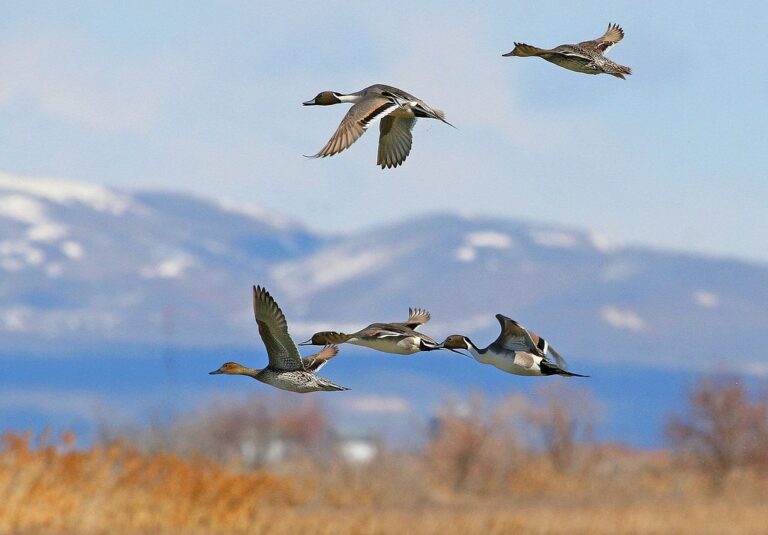
Hunts, dinners and trials by Kay County OLAP Walk-In Hunting Area H020
Rows marked for this land use it as the venue; the others lie within about 10 miles. In all, 1 upcoming listing.
Not yet held
| Dates | Event | Mi | Where | Button | Source |
|---|---|---|---|---|---|
| Jan 16, 2027 | Kaw Dinner-Ponca City · DU chapter dinner | 10 | Ponca City: MLZ Ranch | Buy tickets | Source |
Before you ask about Kay OLAP tract H020
What antlerless limit applies near Kay OLAP tract H020?
ODWC map overlay: Zone 2 (Muzzleloader 4, gun 4); the legal line is the road on the map. Area rules can narrow it further.
Which documents cover a hunt on Kay OLAP tract H020?
A hunting license (unless exempt) plus the Land Access Permit, $100 resident / $200 nonresident.
Which seasons can I hunt on Kay OLAP tract H020?
Deer, dove, waterfowl, turkey by the layer.
Does the bait ban cover Kay OLAP tract H020?
Not allowed. The Department-Managed Area Rules prohibit bait.
What other public ground lies close to Kay OLAP tract H020?
Kaw Lake (Corps), about 21 mi east. Kay OLAP limited access LA001 is the closest OLAP neighbor, 0.4 mi.
Who owns and runs Kay OLAP tract H020?
The managing body is the Oklahoma Department of Wildlife Conservation (leased private land). Nearest ODWC desk: Oklahoma City.
How early is legal light at Kay OLAP tract H020 in late November?
Deer and other big game: half an hour before sunrise to half an hour after sunset; on November 21, 2026 that works out to 6:43 a.m. to 5:47 p.m. for Kay County. Quail and pheasant stop at 4:30 p.m. on OLAP.
How much fluorescent orange is required on Kay OLAP tract H020?
Firearm deer, elk, bear and pronghorn hunters wear 400 square inches of daylight fluorescent orange on a head covering and outer garment combined. Gun deer is closed on OLAP, but archers still wear orange during open gun dates.
Does Kay OLAP tract H020 have a campground?
No, OLAP forbids camping. Newkirk is closest.
How many deer does the county around Kay OLAP tract H020 produce?
Kay County: 1,325 deer in 2025-26.
What are the archery and gun deer dates at Kay OLAP tract H020?
Statewide dates: archery from Oct 1, 2026, gun from Nov 21, 2026. On OLAP, only archery and shotgun are legal.
Which elk zone is Kay OLAP tract H020 in?
OLAP closes elk. Kay County: Northwest Zone and Northeast Zone.
Before the drive to Kay OLAP tract H020
Report deer, elk, bear, pronghorn and turkey through E-Check within 24 hours, and carry your field tag while hunting Kay OLAP tract H020.
Sources: source · source · source · source; regulations from the 2026-2027 Oklahoma Fishing and Hunting Regulations. Checked November 3, 2026.
Other photos on this page: Clinton Steeds (CC BY 2.0); Clinton Steeds (CC BY 2.0); USFWS Headquarters (CC BY 2.0).