Home › Oklahoma › Public land › Osage WMA
Oklahoma wildlife management area
Osage Wildlife Management Area, Oklahoma hunting
Where, when and how to hunt this wildlife management area, 11,051 acres, in Osage County.
Photo: Brett Chapman (CC BY-SA 2.0)
Getting to Osage Wildlife Management Area
The Osage WMA file
Expect about 11,051 acres of ground at Osage WMA, going by the OLAP layer tract sum. Osage County has 15 records with acreage here; Osage WMA is number 4. Oklahoma Department of Wildlife Conservation has charge of it; ODWC counts the ground in the ODWC Central Region.
Osage County holds 59,496 acres of public land on the GIS layers.
Open game on Osage WMA: Deer, Doves, Rails, Gallinules, Crows, Waterfowl, Turkey, Trapping, Quail, Snipe, Woodcock, Rabbits, Squirrels, Furbearers.
From the agency record (Oklahoma Department of Wildlife Conservation); checked November 3, 2026.
Nearby
Places to hunt and shoot around Osage Wildlife Management Area
Osage WMA: the county rules that apply
| Rule | Osage County |
|---|---|
| Antlerless zone | 2 |
| Elk zone | Northeast |
| Bear area | No |
| Pronghorn | No season |
| Fall gun turkey | Open |
| Pheasant | Whole county |
| Duck dates | Zones 1 and 2 |
| Crane, jackrabbit | No season |
| CWD surveillance | Outside |
| ODWC region | Central |
| Warden district | No. 1 |
Antlerless limits around Osage WMA: Zone 2 (Muzzleloader 4, gun 4). ODWC draws the lines on roads and publishes them only as a map (ODWC antlerless zone map). All zones share the same dates and the six-deer combined limit, with no more than two bucks. Osage County counts toward the Northeast Zone (quota 20); check the quota online before an elk hunt. Fall gun turkey is open in Osage County, one of the 64 open counties. Pheasant hunting is legal in the whole county.
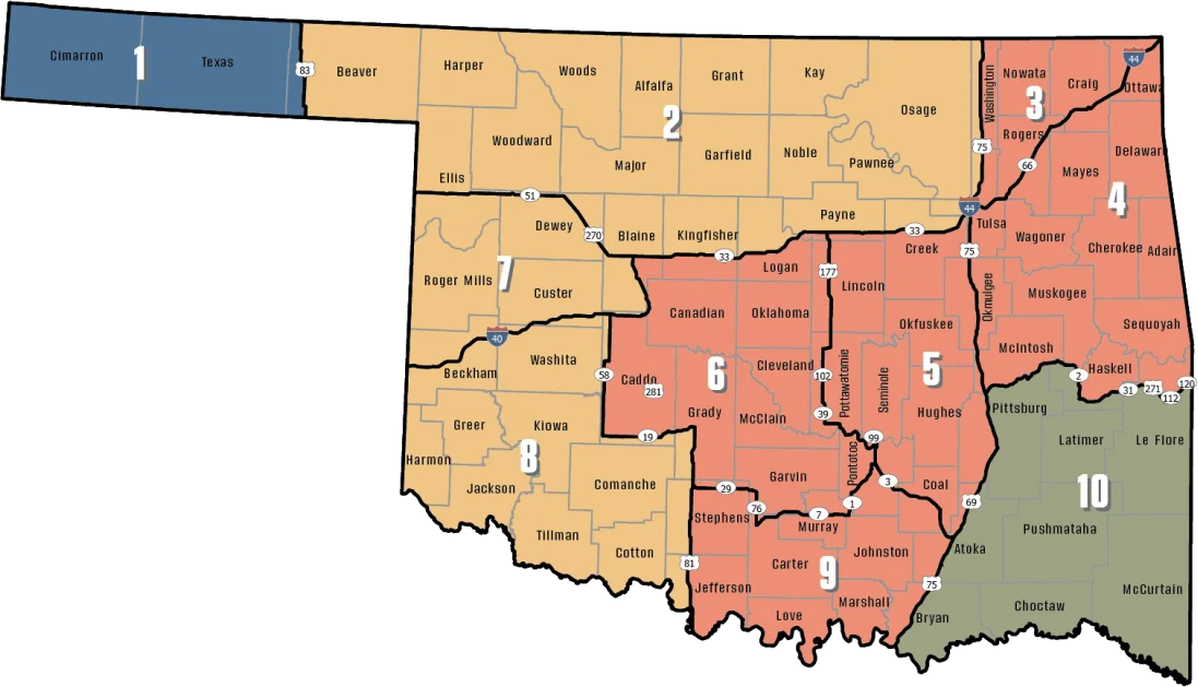
ODWC antlerless deer zones, elk zones, bear area, fall turkey counties, CWD rules; checked November 3, 2026.
Deer checked near Osage WMA
5,062 deer came out of Osage County in 2025-26 (WMA harvest excluded), placing it 1st statewide. Split: gun 3,309, bow 1,287, muzzleloader 466. 2025-26 elk: 1 in Osage County.
ODWC 2025-26 Big Game Harvest Report and earlier ODWC harvest reports (harvest.json); checked November 3, 2026.
Dated seasons covering Osage WMA
Ducks run on Panhandle dates or Zone 1 and 2 dates, and cranes and jackrabbits only west of I-35, which is why the area column matters for Osage WMA.
| Quarry | Segment | Zone or area | Begins | Ends | Open now? |
|---|---|---|---|---|---|
| White-tailed deer | Archery | Zone 2, 7, 8 | Oct 1, 2026 | Jan 15, 2027 | |
| White-tailed deer | Youth gun | Zone 2, 7, 8 | Oct 16, 2026 | Oct 18, 2026 | |
| White-tailed deer | Muzzleloader | Zone 2, 7, 8 | Oct 24, 2026 | Nov 1, 2026 | |
| White-tailed deer | Gun | Zone 2, 7, 8 | Nov 21, 2026 | Dec 6, 2026 | |
| White-tailed deer | Holiday antlerless | Zone 2, 7, 8 | Dec 18, 2026 | Dec 31, 2026 | |
| Mule deer | All deer seasons | Statewide | Oct 1, 2026 | Jan 15, 2027 | |
| Elk | Archery | Northeast elk zone | Oct 1, 2026 | Jan 15, 2027 | |
| Elk | Youth elk gun | Northeast elk zone | Oct 16, 2026 | Oct 18, 2026 | |
| Elk | Muzzleloader | Northeast elk zone | Oct 24, 2026 | Nov 1, 2026 | |
| Elk | Gun | Northeast elk zone | Nov 21, 2026 | Dec 6, 2026 | |
| Elk | Holiday antlerless elk | Northeast elk zone | Dec 18, 2026 | Dec 31, 2026 | |
| Wild turkey | Youth fall turkey | Open counties | Oct 16, 2026 | Oct 18, 2026 | |
| Wild turkey | Fall Gun | Open counties | Oct 31, 2026 | Nov 20, 2026 | |
| Wild turkey | Fall Archery | Statewide | Oct 1, 2026 | Jan 15, 2027 | |
| Wild turkey | Youth Spring | Statewide | Apr 10, 2027 | Apr 11, 2027 | |
| Wild turkey | Spring | Statewide | Apr 16, 2027 | May 16, 2027 | |
| Feral hogs | Private land | Private land | Jul 1, 2026 | Jun 30, 2027 | |
| Quail | Season | Statewide | Nov 14, 2026 | Feb 15, 2027 | |
| Pheasant | Season | Pheasant counties | Dec 1, 2026 | Jan 31, 2027 | |
| Rabbits | Season | Statewide | Oct 1, 2026 | Mar 15, 2027 | |
| Squirrels | Season | Statewide | May 15, 2026 | Feb 28, 2027 | |
| Doves | Segment 1 | Statewide | Sep 1, 2026 | Oct 31, 2026 | |
| Doves | Segment 2 | Statewide | Dec 1, 2026 | Dec 29, 2026 | |
| Teal | September Teal | Statewide | Sep 12, 2026 | Sep 20, 2026 | |
| Ducks | Youth and veteran day | Zones 1 and 2 | Nov 7, 2026 | Nov 7, 2026 | |
| Ducks | Regular segment 1 | Zones 1 and 2 | Nov 14, 2026 | Dec 6, 2026 | |
| Ducks | Regular segment 2 | Zones 1 and 2 | Dec 12, 2026 | Jan 31, 2027 | |
| Ducks | Youth and veteran day | Zones 1 and 2 | Feb 6, 2027 | Feb 6, 2027 | |
| Canada geese | September Canada goose | Statewide | Sep 12, 2026 | Sep 21, 2026 | |
| Dark geese | Segment 1 | Statewide | Nov 7, 2026 | Dec 6, 2026 | |
| Dark geese | Segment 2 | Statewide | Dec 12, 2026 | Feb 14, 2027 | |
| Specklebellies | Segment 1 | Statewide | Nov 7, 2026 | Dec 6, 2026 | |
| Specklebellies | Segment 2 | Statewide | Dec 12, 2026 | Feb 7, 2027 | |
| Light geese | Segment 1 | Statewide | Nov 7, 2026 | Dec 6, 2026 | |
| Light geese | Segment 2 | Statewide | Dec 12, 2026 | Feb 14, 2027 | |
| Light geese | Conservation order | Statewide | Feb 15, 2027 | Mar 30, 2027 | |
| Woodcock | Season | Statewide | Nov 7, 2026 | Dec 21, 2026 | |
| Coyote | Year-round | Statewide | Jul 1, 2026 | Jun 30, 2027 | |
| Bobcat | Furbearer season | Statewide | Dec 1, 2026 | Feb 28, 2027 | |
| Gray fox | Furbearer season | Statewide | Dec 1, 2026 | Feb 28, 2027 | |
| Red fox | Furbearer season | Statewide | Dec 1, 2026 | Feb 28, 2027 | |
| Raccoon | Year-round | Statewide | Jul 1, 2026 | Jun 30, 2027 | |
| Prairie dog | Year-round | Statewide | Jul 1, 2026 | Jun 30, 2027 | |
| Beaver | Year-round | Statewide | Jul 1, 2026 | Jun 30, 2027 | |
| Nutria | Year-round | Statewide | Jul 1, 2026 | Jun 30, 2027 | |
| Striped skunk | Year-round | Statewide | Jul 1, 2026 | Jun 30, 2027 | |
| Bullfrogs | Year-round | Statewide | Jul 1, 2026 | Jun 30, 2027 | |
| Rails | Season | Statewide | Sep 1, 2026 | Nov 9, 2026 | |
| Gallinules | Season | Statewide | Sep 1, 2026 | Nov 9, 2026 | |
| Snipe | Season | Statewide | Sep 26, 2026 | Jan 10, 2027 | |
| Crows | Segment 1 | Statewide | Oct 10, 2026 | Nov 16, 2026 | |
| River otter | Furbearer season | Statewide | Dec 1, 2026 | Feb 28, 2027 | |
| Badger | Furbearer season | Statewide | Dec 1, 2026 | Feb 28, 2027 | |
| Mink | Furbearer season | Statewide | Dec 1, 2026 | Feb 28, 2027 | |
| Muskrat | Furbearer season | Statewide | Dec 1, 2026 | Feb 28, 2027 | |
| Opossum | Furbearer season | Statewide | Dec 1, 2026 | Feb 28, 2027 | |
| Weasel | Furbearer season | Statewide | Dec 1, 2026 | Feb 28, 2027 | |
| Crows | Segment 2 | Statewide | Dec 9, 2026 | Mar 4, 2027 | |
| Rattlesnakes | Season | Statewide | Mar 1, 2027 | Jun 30, 2027 |
From the ODWC hunting regulations and the 2026-2027 Oklahoma Fishing and Hunting Regulations (Oklahoma Department of Wildlife Conservation), checked November 3, 2026.
Osage WMA on the map with its neighbors
The table starts with Hulah WMA (9.3 mi, northeast). OLAP access is 24 mi away at Osage OLAP tract H006.
| Public land | Type | Acres | County | Distance | Direction |
|---|---|---|---|---|---|
| Hulah WMA | WMA | 16,162 | Osage | 9.3 mi | northeast |
| Hulah Lake (Corps) | Corps lake | – | Osage | 12 mi | northeast |
| John Dahl WMA | WMA | 480 | Osage | 13 mi | west |
| Copan Lake (Corps) | Corps lake | – | Washington | 20 mi | east |
| Copan WMA | WMA | 7,532 | Washington | 22 mi | east |
| Candy Creek WMA | WMA | 605 | Osage | 30 mi | southeast |
Points: ODWC Public WMA Boundaries layer (polygon centroid of the largest part). Straight-line distances. Statewide public land map.
Osage WMA: nearest towns, offices and shops
Bowring sits 11 mi from Osage WMA in a straight line. Bartlesville is the largest of these towns, with 38,355 people in 2024. Nearby Census places: Foraker (14 mi, 17 people). Hank Jenks captains warden District 1, which includes Osage County: (918) 331-5078.
| Nearest towns | County | Population | Miles | Heading |
|---|---|---|---|---|
| Bowring | Osage | – | 11 mi | east |
| Whippoorwill | Osage | – | 11 mi | east |
| Pawhuska | Osage | 2,923 | 13 mi | south |
| Copan | Washington | 729 | 21 mi | east |
| Bartlesville | Washington | 38,355 | 22 mi | southeast |
Towns from places.json and census_places.json (Census 2024); offices and businesses from services.json; warden numbers from the ODWC area page or warden directory; straight-line miles. Checked November 3, 2026.
Osage Wildlife Management Area: the WMA bench nearest it, then clubs
For a license-only bench, Osage Wildlife Management Area hunters head 20 miles to Copan WMA Shooting Range. Nearby clubs fill the other cards.
From ODWC’s WMA shooting range list and WMA pages, operators’ pages and directory listings, checked November 3, 2026.
Osage WMA legal light
The Panhandle sees the sun up to half an hour later than the Arkansas line, so use the times worked out for Osage WMA.
| Date | Season point | Sunrise | Sunset | Big game | Waterfowl | Quail |
|---|---|---|---|---|---|---|
| Oct 1, 2026 | Archery deer opens | 7:20 a.m. | 7:11 p.m. | 6:50 a.m. to 7:41 p.m. | 6:50 a.m. to 7:11 p.m. | 7:20 a.m. to 7:11 p.m. |
| Oct 24, 2026 | Muzzleloader opens | 7:40 a.m. | 6:39 p.m. | 7:10 a.m. to 7:09 p.m. | 7:10 a.m. to 6:39 p.m. | 7:40 a.m. to 6:39 p.m. |
| Nov 21, 2026 | Gun deer opens | 7:09 a.m. | 5:14 p.m. | 6:39 a.m. to 5:44 p.m. | 6:39 a.m. to 5:14 p.m. | 7:09 a.m. to 5:14 p.m. |
| Dec 6, 2026 | Gun deer closes | 7:24 a.m. | 5:10 p.m. | 6:54 a.m. to 5:40 p.m. | 6:54 a.m. to 5:10 p.m. | 7:24 a.m. to 5:10 p.m. |
| Dec 21, 2026 | Shortest day | 7:34 a.m. | 5:13 p.m. | 7:04 a.m. to 5:43 p.m. | 7:04 a.m. to 5:13 p.m. | 7:34 a.m. to 5:13 p.m. |
| Jan 15, 2027 | Archery closes | 7:37 a.m. | 5:32 p.m. | 7:07 a.m. to 6:02 p.m. | 7:07 a.m. to 5:32 p.m. | 7:37 a.m. to 5:32 p.m. |
| Apr 16, 2027 | Spring turkey | 6:52 a.m. | 7:59 p.m. | 6:22 a.m. to 8:29 p.m. | 6:22 a.m. to 7:59 p.m. | 6:52 a.m. to 7:59 p.m. |
Hours rules from the ODWC big game regulations and the 2026-2027 Oklahoma Fishing and Hunting Regulations; sunrise and sunset worked out for this location with the NOAA solar formula (Central Time); checked November 3, 2026. Legal hours for every county.
Oklahoma views around Osage WMA
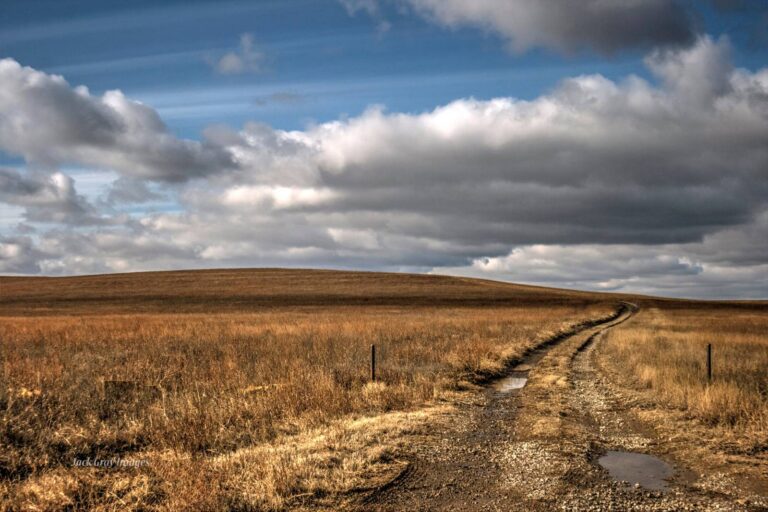

Calendar dates at and around Osage Wildlife Management Area
Near this property on November 3, 2026: 2 upcoming listings. Count 2 draw-only controlled hunts among them.
Still on the calendar
| When | Listing | Distance | Area or venue | Next step | Read at |
|---|---|---|---|---|---|
| Nov 6–17, 2026 | Osage-Western Wall WMA deer controlled hunt | 0 | Event details | Source | |
| Nov 18–23, 2026 | Osage WMA youth deer hunt | Here | Event details | Source |
Osage WMA answers from the sources
What was the 2025-26 deer harvest in Osage County?
5,062 deer in 2025-26 for Osage County (county rows exclude WMA harvest).
Is elk hunting possible on Osage WMA?
Elk zones (Northeast Zone here) cover private land; public elk come only through the draw.
When does deer season run at Osage WMA?
Archery Oct 1, 2026 to Jan 15, 2027; gun Nov 21, 2026 to Dec 6, 2026. Check the area table.
What corner of the state is Osage WMA in?
It lies in Osage County (ODWC Central Region). Bowring lies roughly 11 mi from it.
How much ground does Osage WMA take in?
Roughly 11,051 acres, by the OLAP layer tract sum.
Is a Land Access Permit or other pass needed for Osage WMA?
A license or exemption plus species licenses; nonresidents check in.
Which antlerless zone line runs near Osage WMA?
Zone 2 (Muzzleloader 4, gun 4). Six deer a season, two antlered at most, still applies.
Does the bait ban cover Osage WMA?
No baiting here; Department rules forbid it.
What animals does Osage WMA carry seasons for?
Listed game: deer, doves, rails, gallinules, crows, waterfowl, turkey, trapping, quail, snipe, woodcock, rabbits, squirrels and furbearers.
Who answers questions about Osage WMA?
It falls under the Oklahoma Department of Wildlife Conservation. Nearest ODWC desk: Oklahoma City.
Where is a backup spot near Osage WMA?
Hulah WMA (9.3 mi away).
How much fluorescent orange is required on Osage WMA?
During big game firearm seasons, 400 square inches for gun hunters and an orange head covering or upper garment for most others.
Other photos on this page: Jack Gray (CC BY 2.0); "Topato"/John (CC BY 2.0); Jim, the Photographer (CC BY 2.0).