Home › Oklahoma › Public land › Osage OLAP tract H002
OLAP walk-in · ODWC Central Region
Walk-in hunting on OLAP H002, Osage County
Where, when and how to hunt this OLAP walk-in tract, 162 acres, in Osage County.
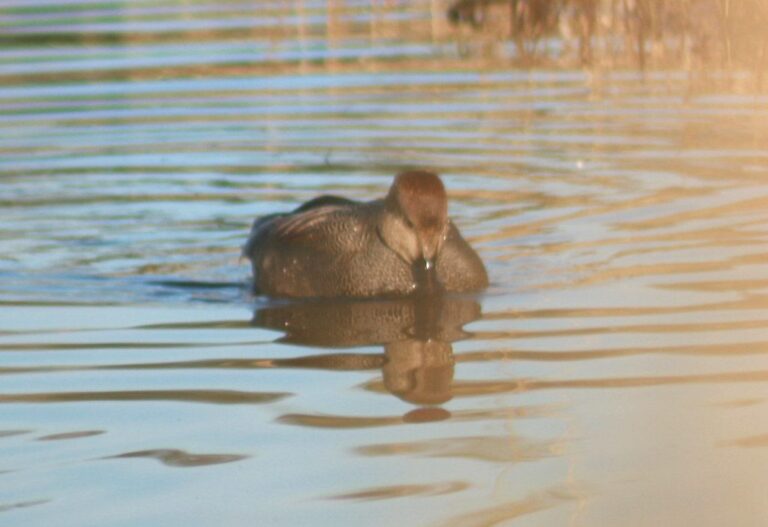
Photo: Jack Gray (CC BY 2.0)
Getting to Osage County OLAP Walk-In Hunting Area H002
Osage OLAP tract H002 at a glance
Osage County landowner ground, 162 acres, enrolled in the Oklahoma Land Access Program. By acreage it places 3rd among 6 tracts in the county, out of 1,292 walk-in acres there. No cover note on the map layer. The map lists deer, duck and dove for it.
| Item | Record |
|---|---|
| OLAP ID | Osage_H002 |
| Acres (layer) | 162 |
| GIS acres | 163 |
| Cover | – |
| Season | Sept. 1 to May 16 |
| County | Osage County |
| County rank | 3 of 6 |
| PATH tract | No |
From the ODWC OLAP layer (OLAP_UpdatedLayers_062626); checked November 3, 2026.
Nearby
Places to hunt and shoot around Osage County OLAP Walk-In Hunting Area H002
County rule table for Osage OLAP tract H002
| Rule | Osage County |
|---|---|
| Antlerless zone | 2 |
| Elk zone | Northeast |
| Bear area | No |
| Pronghorn | No season |
| Fall gun turkey | Open |
| Pheasant | Whole county |
| Duck dates | Zones 1 and 2 |
| Crane, jackrabbit | No season |
| CWD surveillance | Outside |
| ODWC region | Central |
| Warden district | No. 1 |
Antlerless limits around Osage OLAP tract H002: Zone 2 (Muzzleloader 4, gun 4). ODWC draws the lines on roads and publishes them only as a map (ODWC antlerless zone map). All zones share the same dates and the six-deer combined limit, with no more than two bucks. Elk are the one season OLAP excludes; Osage County sits in the Northeast Zone. Fall gun turkey is open in Osage County, one of the 64 open counties. Pheasant hunting is legal in the whole county.
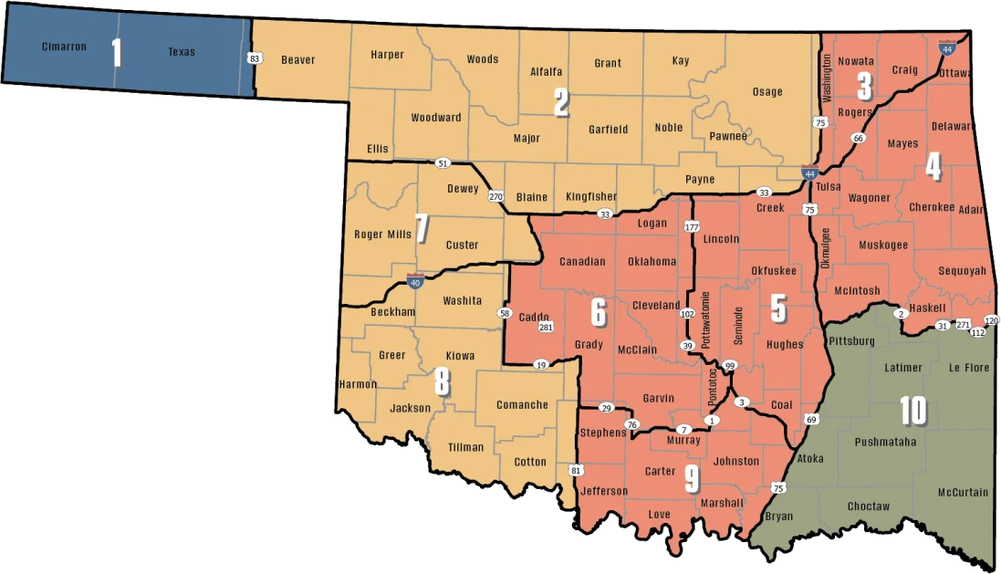
ODWC antlerless deer zones, elk zones, bear area, fall turkey counties, CWD rules; checked November 3, 2026.
Rules for hunting Osage OLAP tract H002
| What | Here |
|---|---|
| Permit | Land Access Permit |
| Fee | $100 / $200 |
| Weapons | Archery, shotgun |
| Largest shot | T |
| Access | Foot only |
| Open | Sept. 1 to May 16 |
| Quail, pheasant | End 4:30 p.m. |
| Elk | Closed |
| Camping | Not allowed |
Walking onto Osage OLAP tract H002 takes a Land Access Permit ($100 resident / $200 nonresident) for residents 18 to 63, every nonresident and lifetime license holders; residents 17 and under or 64 and over are exempt. Deer on this tract fall to archery equipment, since rifles, muzzleloaders and slugs are all prohibited. Entry runs from two hours before sunrise to one hour after sunset, on foot only. Bird hunters note the 4:30 p.m. cutoff for quail and pheasant on walk-in land. All seasons but elk are open; overnight stays, fires and alcohol are banned. If you trap, use water sets, live box traps or enclosed-trigger traps only.
Sources: ODWC OLAP layer, OLAP hunting regulations, OLAP program page, license fees. Checked November 3, 2026.
Harvest figures for Osage OLAP tract H002
5,062 deer came out of Osage County in 2025-26 (WMA harvest excluded), placing it 1st statewide. Split: gun 3,309, bow 1,287, muzzleloader 466. 2025-26 elk: 1 in Osage County.
ODWC 2025-26 Big Game Harvest Report and earlier ODWC harvest reports (harvest.json); checked November 3, 2026.
Dated seasons covering Osage OLAP tract H002
Ducks run on Panhandle dates or Zone 1 and 2 dates, and cranes and jackrabbits only west of I-35, which is why the area column matters for Osage OLAP tract H002.
| Quarry | Segment | Zone or area | Begins | Ends | Open now? |
|---|---|---|---|---|---|
| White-tailed deer | Archery | Zone 2, 7, 8 | Oct 1, 2026 | Jan 15, 2027 | |
| White-tailed deer | Youth gun | Zone 2, 7, 8 | Oct 16, 2026 | Oct 18, 2026 | |
| White-tailed deer | Muzzleloader | Zone 2, 7, 8 | Oct 24, 2026 | Nov 1, 2026 | |
| White-tailed deer | Gun | Zone 2, 7, 8 | Nov 21, 2026 | Dec 6, 2026 | |
| White-tailed deer | Holiday antlerless | Zone 2, 7, 8 | Dec 18, 2026 | Dec 31, 2026 | |
| Mule deer | All deer seasons | Statewide | Oct 1, 2026 | Jan 15, 2027 | |
| Elk | Archery | Northeast elk zone | Oct 1, 2026 | Jan 15, 2027 | |
| Elk | Youth elk gun | Northeast elk zone | Oct 16, 2026 | Oct 18, 2026 | |
| Elk | Muzzleloader | Northeast elk zone | Oct 24, 2026 | Nov 1, 2026 | |
| Elk | Gun | Northeast elk zone | Nov 21, 2026 | Dec 6, 2026 | |
| Elk | Holiday antlerless elk | Northeast elk zone | Dec 18, 2026 | Dec 31, 2026 | |
| Wild turkey | Youth fall turkey | Open counties | Oct 16, 2026 | Oct 18, 2026 | |
| Wild turkey | Fall Gun | Open counties | Oct 31, 2026 | Nov 20, 2026 | |
| Wild turkey | Fall Archery | Statewide | Oct 1, 2026 | Jan 15, 2027 | |
| Wild turkey | Youth Spring | Statewide | Apr 10, 2027 | Apr 11, 2027 | |
| Wild turkey | Spring | Statewide | Apr 16, 2027 | May 16, 2027 | |
| Feral hogs | Private land | Private land | Jul 1, 2026 | Jun 30, 2027 | |
| Quail | Season | Statewide | Nov 14, 2026 | Feb 15, 2027 | |
| Pheasant | Season | Pheasant counties | Dec 1, 2026 | Jan 31, 2027 | |
| Rabbits | Season | Statewide | Oct 1, 2026 | Mar 15, 2027 | |
| Squirrels | Season | Statewide | May 15, 2026 | Feb 28, 2027 | |
| Doves | Segment 1 | Statewide | Sep 1, 2026 | Oct 31, 2026 | |
| Doves | Segment 2 | Statewide | Dec 1, 2026 | Dec 29, 2026 | |
| Teal | September Teal | Statewide | Sep 12, 2026 | Sep 20, 2026 | |
| Ducks | Youth and veteran day | Zones 1 and 2 | Nov 7, 2026 | Nov 7, 2026 | |
| Ducks | Regular segment 1 | Zones 1 and 2 | Nov 14, 2026 | Dec 6, 2026 | |
| Ducks | Regular segment 2 | Zones 1 and 2 | Dec 12, 2026 | Jan 31, 2027 | |
| Ducks | Youth and veteran day | Zones 1 and 2 | Feb 6, 2027 | Feb 6, 2027 | |
| Canada geese | September Canada goose | Statewide | Sep 12, 2026 | Sep 21, 2026 | |
| Dark geese | Segment 1 | Statewide | Nov 7, 2026 | Dec 6, 2026 | |
| Dark geese | Segment 2 | Statewide | Dec 12, 2026 | Feb 14, 2027 | |
| Specklebellies | Segment 1 | Statewide | Nov 7, 2026 | Dec 6, 2026 | |
| Specklebellies | Segment 2 | Statewide | Dec 12, 2026 | Feb 7, 2027 | |
| Light geese | Segment 1 | Statewide | Nov 7, 2026 | Dec 6, 2026 | |
| Light geese | Segment 2 | Statewide | Dec 12, 2026 | Feb 14, 2027 | |
| Light geese | Conservation order | Statewide | Feb 15, 2027 | Mar 30, 2027 | |
| Woodcock | Season | Statewide | Nov 7, 2026 | Dec 21, 2026 | |
| Coyote | Year-round | Statewide | Jul 1, 2026 | Jun 30, 2027 | |
| Bobcat | Furbearer season | Statewide | Dec 1, 2026 | Feb 28, 2027 | |
| Gray fox | Furbearer season | Statewide | Dec 1, 2026 | Feb 28, 2027 | |
| Red fox | Furbearer season | Statewide | Dec 1, 2026 | Feb 28, 2027 | |
| Raccoon | Year-round | Statewide | Jul 1, 2026 | Jun 30, 2027 | |
| Prairie dog | Year-round | Statewide | Jul 1, 2026 | Jun 30, 2027 | |
| Beaver | Year-round | Statewide | Jul 1, 2026 | Jun 30, 2027 | |
| Nutria | Year-round | Statewide | Jul 1, 2026 | Jun 30, 2027 | |
| Striped skunk | Year-round | Statewide | Jul 1, 2026 | Jun 30, 2027 | |
| Bullfrogs | Year-round | Statewide | Jul 1, 2026 | Jun 30, 2027 | |
| Rails | Season | Statewide | Sep 1, 2026 | Nov 9, 2026 | |
| Gallinules | Season | Statewide | Sep 1, 2026 | Nov 9, 2026 | |
| Snipe | Season | Statewide | Sep 26, 2026 | Jan 10, 2027 | |
| Crows | Segment 1 | Statewide | Oct 10, 2026 | Nov 16, 2026 | |
| River otter | Furbearer season | Statewide | Dec 1, 2026 | Feb 28, 2027 | |
| Badger | Furbearer season | Statewide | Dec 1, 2026 | Feb 28, 2027 | |
| Mink | Furbearer season | Statewide | Dec 1, 2026 | Feb 28, 2027 | |
| Muskrat | Furbearer season | Statewide | Dec 1, 2026 | Feb 28, 2027 | |
| Opossum | Furbearer season | Statewide | Dec 1, 2026 | Feb 28, 2027 | |
| Weasel | Furbearer season | Statewide | Dec 1, 2026 | Feb 28, 2027 | |
| Crows | Segment 2 | Statewide | Dec 9, 2026 | Mar 4, 2027 | |
| Rattlesnakes | Season | Statewide | Mar 1, 2027 | Jun 30, 2027 |
From the ODWC hunting regulations and the 2026-2027 Oklahoma Fishing and Hunting Regulations (Oklahoma Department of Wildlife Conservation), checked November 3, 2026.
Distances from Osage OLAP tract H002 to other public land
The table starts with Skiatook Lake (Corps) (5.7 mi, southwest). The nearest other walk-in tract is Osage OLAP limited access LA001, 38 mi northwest.
| Public land | Type | Acres | County | Distance | Direction |
|---|---|---|---|---|---|
| Skiatook Lake (Corps) | Corps lake | – | Osage | 5.7 mi | southwest |
| Candy Creek WMA | WMA | 605 | Osage | 7.3 mi | northeast |
| Skiatook WMA | WMA | 5,085 | Osage | 8.8 mi | southwest |
| Keystone Lake (Corps) | Corps lake | – | Pawnee, Osage | 21 mi | southwest |
| Osage WMA Rock Creek Unit (3,722 acres) | WMA unit | 3,722 | Osage | 27 mi | north |
| Keystone WMA | WMA | 20,686 | Creek, Osage | 30 mi | southwest |
More OLAP near Osage OLAP tract H002
| Public land | Type | Acres | County | Distance | Direction |
|---|---|---|---|---|---|
| Osage OLAP limited access LA001 | OLAP limited access | 320 | Osage | 38 mi | northwest |
| Osage OLAP tract H004 | OLAP walk-in | 480 | Osage | 39 mi | northwest |
| Osage OLAP tract H005 | OLAP walk-in | 160 | Osage | 40 mi | northwest |
| Osage OLAP tract H006 | OLAP walk-in | 90 | Osage | 44 mi | northwest |
Points: ODWC OLAP Walk-In Access layer (tract polygon) (polygon centroid). Straight-line distances. Statewide public land map.
Where Osage OLAP tract H002 hunters resupply
Sperry, 13 mi off, is the closest town with a page here. Owasso is the largest of these towns, with 42,821 people in 2024. Nearby Census places: Avant (5.8 mi, 302 people) and Barnsdall (8.1 mi, 975 people). Hank Jenks captains warden District 1, which includes Osage County: (918) 331-5078.
| Nearest towns | County | Population | Miles | Heading |
|---|---|---|---|---|
| Sperry | Tulsa | 1,244 | 13 mi | southeast |
| Hominy | Osage | 3,286 | 14 mi | west |
| Prue | Osage | 396 | 15 mi | southwest |
| Pawhuska | Osage | 2,923 | 19 mi | northwest |
| Owasso | Tulsa | 42,821 | 20 mi | southeast |
Towns from places.json and census_places.json (Census 2024); offices and businesses from services.json; warden numbers from the ODWC area page or warden directory; straight-line miles. Checked November 3, 2026.
Osage County OLAP Walk-In Hunting Area H002: the WMA bench nearest it, then clubs
For a license-only bench, Osage County OLAP Walk-In Hunting Area H002 hunters head 36 miles to Copan WMA Shooting Range. Nearby clubs fill the other cards.
From ODWC’s WMA shooting range list and WMA pages, operators’ pages and directory listings, checked November 3, 2026.
First and last shooting light, Osage OLAP tract H002
The Panhandle sees the sun up to half an hour later than the Arkansas line, so use the times worked out for Osage OLAP tract H002.
| Date | Season point | Sunrise | Sunset | Big game | Waterfowl | Quail |
|---|---|---|---|---|---|---|
| Oct 1, 2026 | Archery deer opens | 7:20 a.m. | 7:11 p.m. | 6:50 a.m. to 7:41 p.m. | 6:50 a.m. to 7:11 p.m. | 7:20 a.m. to 7:11 p.m. |
| Oct 24, 2026 | Muzzleloader opens | 7:40 a.m. | 6:39 p.m. | 7:10 a.m. to 7:09 p.m. | 7:10 a.m. to 6:39 p.m. | 7:40 a.m. to 6:39 p.m. |
| Nov 21, 2026 | Gun deer opens | 7:09 a.m. | 5:14 p.m. | 6:39 a.m. to 5:44 p.m. | 6:39 a.m. to 5:14 p.m. | 7:09 a.m. to 5:14 p.m. |
| Dec 6, 2026 | Gun deer closes | 7:24 a.m. | 5:10 p.m. | 6:54 a.m. to 5:40 p.m. | 6:54 a.m. to 5:10 p.m. | 7:24 a.m. to 5:10 p.m. |
| Dec 21, 2026 | Shortest day | 7:34 a.m. | 5:13 p.m. | 7:04 a.m. to 5:43 p.m. | 7:04 a.m. to 5:13 p.m. | 7:34 a.m. to 5:13 p.m. |
| Jan 15, 2027 | Archery closes | 7:37 a.m. | 5:32 p.m. | 7:07 a.m. to 6:02 p.m. | 7:07 a.m. to 5:32 p.m. | 7:37 a.m. to 5:32 p.m. |
| Apr 16, 2027 | Spring turkey | 6:52 a.m. | 7:59 p.m. | 6:22 a.m. to 8:29 p.m. | 6:22 a.m. to 7:59 p.m. | 6:52 a.m. to 7:59 p.m. |
Hours rules from the ODWC big game regulations and the 2026-2027 Oklahoma Fishing and Hunting Regulations; sunrise and sunset worked out for this location with the NOAA solar formula (Central Time); checked November 3, 2026. Legal hours for every county.
Photos near and like Osage OLAP tract H002


Events on or near Osage County OLAP Walk-In Hunting Area H002
Near this property on November 3, 2026: 1 upcoming listing. Count 1 draw-only controlled hunt among them.
Still on the calendar
| Held | Event | Distance | Where held | Action | Checked at |
|---|---|---|---|---|---|
| Dec 11–13, 2026 | Skiatook COE youth deer hunt | 6 | Event details | Source |
Osage OLAP tract H002: short answers
Can I stay the night on Osage OLAP tract H002?
Not on OLAP; stay in a nearby town. Nearest town page: Sperry.
What are the elk rules around Osage OLAP tract H002?
No. Elk hunting is prohibited on OLAP; Osage County is in Northeast Zone, which covers private land only.
When does deer season run at Osage OLAP tract H002?
Archery Oct 1, 2026 to Jan 15, 2027; gun Nov 21, 2026 to Dec 6, 2026. Check the area table. Walk-in tracts are bow and shotgun only.
How many OLAP tracts are in Osage County?
6 tracts with 1,292 acres in the ODWC OLAP layer.
Which ODWC region does Osage OLAP tract H002 fall under?
Osage County, in the ODWC Central Region. Sperry lies roughly 13 mi from it.
How much ground does Osage OLAP tract H002 take in?
The figure used is 162 acres, from the ODWC OLAP layer.
Is a Land Access Permit or other pass needed for Osage OLAP tract H002?
The Land Access Permit ($100 resident / $200 nonresident) on top of your hunting license.
Which antlerless zone line runs near Osage OLAP tract H002?
Zone 2 (Muzzleloader 4, gun 4). Six deer a season, two antlered at most, still applies. Check the area rules too.
Is feeding game allowed for hunting on Osage OLAP tract H002?
No baiting here; Department rules forbid it.
Which species are open on Osage OLAP tract H002?
Deer, duck, dove, plus any statewide season except elk.
Who is the land manager for Osage OLAP tract H002?
Land manager on record: Oklahoma Department of Wildlife Conservation (leased private land). Nearest ODWC desk: Oklahoma City.
Where is a backup spot near Osage OLAP tract H002?
Skiatook Lake (Corps) (5.7 mi away). Closest other tract: Osage OLAP limited access LA001 at 38 mi.
Heading to Osage OLAP tract H002?
Report a violation on Osage OLAP tract H002 to the game warden numbers on this page.
Sources: source · source · source · source; regulations from the 2026-2027 Oklahoma Fishing and Hunting Regulations. Checked November 3, 2026.
Other photos on this page: Brett Chapman (CC BY-SA 2.0); "Topato"/John (CC BY 2.0); born1945 (CC BY 2.0).