Home › Oklahoma › Public land › Osage OLAP tract H004
OLAP walk-in · 2026-27
Hunting OLAP H004 in Osage County
Rules, permits and dates for this OLAP walk-in tract, 480 acres, in Osage County.
Photo: Jack Gray (CC BY 2.0)
Getting to Osage County OLAP Walk-In Hunting Area H004
How Osage OLAP tract H004 may be hunted
| Rule | Osage OLAP tract H004 |
|---|---|
| Permit | Land Access Permit |
| Fee | $100 / $200 |
| Weapons | Archery, shotgun |
| Largest shot | T |
| Access | Foot only |
| Open | Sept. 1 to May 16 |
| Quail, pheasant | End 4:30 p.m. |
| Elk | Closed |
| Camping | Not allowed |
ODWC pays the landowner a yearly lease, and the Land Access Permit ($100 resident / $200 nonresident) helps cover it; lifetime license holders are not exempt. Shotgun and archery only: ODWC bans slugs, rifles and muzzleloaders on OLAP walk-in ground. Park off the tract and walk in; access opens two hours before sunrise and ends one hour after sunset. The OLAP quail and pheasant day ends at 4:30 p.m., not at sunset. Elk stay off limits, as do campfires, alcohol and overnight camping. Trappers are limited to water sets, live box traps and enclosed-trigger traps.
Osage OLAP tract H004 carries the PATH tag from Pheasants Forever and Quail Forever.
Sources: ODWC OLAP layer, OLAP hunting regulations, OLAP program page, license fees. Checked November 3, 2026.
Nearby
Places to hunt and shoot around Osage County OLAP Walk-In Hunting Area H004
Osage OLAP tract H004: size, cover and game
ODWC leases these 480 acres in Osage County from a private owner and opens them to walk-in hunters. 6 walk-in tracts share 1,292 acres across Osage County; size rank here: 1. The layer records the ground as Native Range and Timber with Creek Bottom. The species field names deer, doves, quail, rabbit and ducks. Its polygon comes to 475 acres.
| Item | Value |
|---|---|
| OLAP ID | Osage_H004 |
| Acres (layer) | 480 |
| GIS acres | 475 |
| Cover | Native Range and Timber with Creek Bottom |
| Season | Sept. 1 to May 16 |
| County | Osage County |
| County rank | 1 of 6 |
| PATH tract | Yes |
From the ODWC OLAP layer (OLAP_UpdatedLayers_062626); checked November 3, 2026.
What the county rules mean for Osage OLAP tract H004
| Item | Osage County |
|---|---|
| Antlerless zone | 2 |
| Elk zone | Northeast |
| Bear area | No |
| Pronghorn | No season |
| Fall gun turkey | Open |
| Pheasant | Whole county |
| Duck dates | Zones 1 and 2 |
| Crane, jackrabbit | No season |
| CWD surveillance | Outside |
| ODWC region | Central |
| Warden district | No. 1 |
For does, Osage OLAP tract H004 falls in Zone 2 (Muzzleloader 4, gun 4). Check the ODWC antlerless zone map if you hunt near a zone road. Zone limits sit inside the statewide six-deer total; only two may carry antlers of 3 inches or more. Elk may not be hunted on OLAP ground; the Northeast Zone covers other private land in Osage County with written permission. Fall gun turkey: open in Osage County. Roosters may be hunted in the whole county of Osage County.
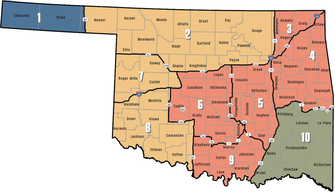
ODWC antlerless deer zones, elk zones, bear area, fall turkey counties, CWD rules; checked November 3, 2026.
Mapping Osage OLAP tract H004 and nearby land
Kaw Lake (Corps) sits 7.8 mi to the northwest, the nearest public area outside the OLAP program. Walk north? Osage OLAP tract H005 lies 0.5 mi away.
| Name | Type | Size (ac) | County | Away | Bearing |
|---|---|---|---|---|---|
| Kaw Lake (Corps) | Corps lake | – | Kay, Osage | 7.8 mi | northwest |
| John Dahl WMA | WMA | 480 | Osage | 15 mi | northeast |
| Kaw WMA | WMA | 17,450 | Kay, Osage | 16 mi | northwest |
| Osage WMA | WMA | 11,051 | Osage | 27 mi | east |
| Osage WMA Western Wall Unit (7,329 acres) | WMA unit | 7,329 | Osage | 27 mi | east |
| Osage WMA Rock Creek Unit (3,722 acres) | WMA unit | 3,722 | Osage | 30 mi | east |
Walk-in tracts closest to Osage OLAP tract H004
| Name | Type | Size (ac) | County | Away | Bearing |
|---|---|---|---|---|---|
| Osage OLAP tract H005 | OLAP walk-in | 160 | Osage | 0.5 mi | north |
| Osage OLAP limited access LA001 | OLAP limited access | 320 | Osage | 1.5 mi | east |
| Osage OLAP tract H006 | OLAP walk-in | 90 | Osage | 8.6 mi | north |
| Osage OLAP tract H003 | OLAP walk-in | 80 | Osage | 10.0 mi | west |
Points: ODWC OLAP Walk-In Access layer (tract polygon) (polygon centroid). Straight-line distances. Statewide public land map.
Deer checked near Osage OLAP tract H004
Statewide rank 1 of 77: Osage County logged 5,062 deer in 2025-26, 2,877 antlered. Methods: 3,309 gun, 466 muzzleloader, 1,287 archery. Osage County also reported 1 elk in 2025-26.
ODWC 2025-26 Big Game Harvest Report and earlier ODWC harvest reports (harvest.json); checked November 3, 2026.
Shops and offices close to Osage OLAP tract H004
Kaw City sits 6.6 mi from Osage OLAP tract H004 in a straight line. Hominy counted 3,286 people in 2024, the most of the five. Smaller Census places closer in: Burbank (2.3 mi, 125 people) and Webb City (6.5 mi, 61 people). Call (918) 331-5078 (Hank Jenks, District 1) about wardens in Osage County.
| Community | County | Residents | Straight line | Direction |
|---|---|---|---|---|
| Kaw City | Kay | 327 | 6.6 mi | northwest |
| Newkirk | Kay | 2,243 | 20 mi | northwest |
| Pawhuska | Osage | 2,923 | 24 mi | east |
| Pawnee | Pawnee | 1,971 | 26 mi | south |
| Hominy | Osage | 3,286 | 29 mi | southeast |
Towns from places.json and census_places.json (Census 2024); offices and businesses from services.json; warden numbers from the ODWC area page or warden directory; straight-line miles. Checked November 3, 2026.
When each season opens near Osage OLAP tract H004
Oklahoma runs one set of deer dates statewide; Osage OLAP tract H004 sits in antlerless Zone 2, which only changes how many does a hunter may take. The 59 rows below are from the ODWC regulation pages.
| Game | Method | Covers | Opening day | Closing day | Now |
|---|---|---|---|---|---|
| White-tailed deer | Archery | Zone 2, 7, 8 | Oct 1, 2026 | Jan 15, 2027 | |
| White-tailed deer | Youth gun | Zone 2, 7, 8 | Oct 16, 2026 | Oct 18, 2026 | |
| White-tailed deer | Muzzleloader | Zone 2, 7, 8 | Oct 24, 2026 | Nov 1, 2026 | |
| White-tailed deer | Gun | Zone 2, 7, 8 | Nov 21, 2026 | Dec 6, 2026 | |
| White-tailed deer | Holiday antlerless | Zone 2, 7, 8 | Dec 18, 2026 | Dec 31, 2026 | |
| Mule deer | All deer seasons | Statewide | Oct 1, 2026 | Jan 15, 2027 | |
| Elk | Archery | Northeast elk zone | Oct 1, 2026 | Jan 15, 2027 | |
| Elk | Youth elk gun | Northeast elk zone | Oct 16, 2026 | Oct 18, 2026 | |
| Elk | Muzzleloader | Northeast elk zone | Oct 24, 2026 | Nov 1, 2026 | |
| Elk | Gun | Northeast elk zone | Nov 21, 2026 | Dec 6, 2026 | |
| Elk | Holiday antlerless elk | Northeast elk zone | Dec 18, 2026 | Dec 31, 2026 | |
| Wild turkey | Youth fall turkey | Open counties | Oct 16, 2026 | Oct 18, 2026 | |
| Wild turkey | Fall Gun | Open counties | Oct 31, 2026 | Nov 20, 2026 | |
| Wild turkey | Fall Archery | Statewide | Oct 1, 2026 | Jan 15, 2027 | |
| Wild turkey | Youth Spring | Statewide | Apr 10, 2027 | Apr 11, 2027 | |
| Wild turkey | Spring | Statewide | Apr 16, 2027 | May 16, 2027 | |
| Feral hogs | Private land | Private land | Jul 1, 2026 | Jun 30, 2027 | |
| Quail | Season | Statewide | Nov 14, 2026 | Feb 15, 2027 | |
| Pheasant | Season | Pheasant counties | Dec 1, 2026 | Jan 31, 2027 | |
| Rabbits | Season | Statewide | Oct 1, 2026 | Mar 15, 2027 | |
| Squirrels | Season | Statewide | May 15, 2026 | Feb 28, 2027 | |
| Doves | Segment 1 | Statewide | Sep 1, 2026 | Oct 31, 2026 | |
| Doves | Segment 2 | Statewide | Dec 1, 2026 | Dec 29, 2026 | |
| Teal | September Teal | Statewide | Sep 12, 2026 | Sep 20, 2026 | |
| Ducks | Youth and veteran day | Zones 1 and 2 | Nov 7, 2026 | Nov 7, 2026 | |
| Ducks | Regular segment 1 | Zones 1 and 2 | Nov 14, 2026 | Dec 6, 2026 | |
| Ducks | Regular segment 2 | Zones 1 and 2 | Dec 12, 2026 | Jan 31, 2027 | |
| Ducks | Youth and veteran day | Zones 1 and 2 | Feb 6, 2027 | Feb 6, 2027 | |
| Canada geese | September Canada goose | Statewide | Sep 12, 2026 | Sep 21, 2026 | |
| Dark geese | Segment 1 | Statewide | Nov 7, 2026 | Dec 6, 2026 | |
| Dark geese | Segment 2 | Statewide | Dec 12, 2026 | Feb 14, 2027 | |
| Specklebellies | Segment 1 | Statewide | Nov 7, 2026 | Dec 6, 2026 | |
| Specklebellies | Segment 2 | Statewide | Dec 12, 2026 | Feb 7, 2027 | |
| Light geese | Segment 1 | Statewide | Nov 7, 2026 | Dec 6, 2026 | |
| Light geese | Segment 2 | Statewide | Dec 12, 2026 | Feb 14, 2027 | |
| Light geese | Conservation order | Statewide | Feb 15, 2027 | Mar 30, 2027 | |
| Woodcock | Season | Statewide | Nov 7, 2026 | Dec 21, 2026 | |
| Coyote | Year-round | Statewide | Jul 1, 2026 | Jun 30, 2027 | |
| Bobcat | Furbearer season | Statewide | Dec 1, 2026 | Feb 28, 2027 | |
| Gray fox | Furbearer season | Statewide | Dec 1, 2026 | Feb 28, 2027 | |
| Red fox | Furbearer season | Statewide | Dec 1, 2026 | Feb 28, 2027 | |
| Raccoon | Year-round | Statewide | Jul 1, 2026 | Jun 30, 2027 | |
| Prairie dog | Year-round | Statewide | Jul 1, 2026 | Jun 30, 2027 | |
| Beaver | Year-round | Statewide | Jul 1, 2026 | Jun 30, 2027 | |
| Nutria | Year-round | Statewide | Jul 1, 2026 | Jun 30, 2027 | |
| Striped skunk | Year-round | Statewide | Jul 1, 2026 | Jun 30, 2027 | |
| Bullfrogs | Year-round | Statewide | Jul 1, 2026 | Jun 30, 2027 | |
| Rails | Season | Statewide | Sep 1, 2026 | Nov 9, 2026 | |
| Gallinules | Season | Statewide | Sep 1, 2026 | Nov 9, 2026 | |
| Snipe | Season | Statewide | Sep 26, 2026 | Jan 10, 2027 | |
| Crows | Segment 1 | Statewide | Oct 10, 2026 | Nov 16, 2026 | |
| River otter | Furbearer season | Statewide | Dec 1, 2026 | Feb 28, 2027 | |
| Badger | Furbearer season | Statewide | Dec 1, 2026 | Feb 28, 2027 | |
| Mink | Furbearer season | Statewide | Dec 1, 2026 | Feb 28, 2027 | |
| Muskrat | Furbearer season | Statewide | Dec 1, 2026 | Feb 28, 2027 | |
| Opossum | Furbearer season | Statewide | Dec 1, 2026 | Feb 28, 2027 | |
| Weasel | Furbearer season | Statewide | Dec 1, 2026 | Feb 28, 2027 | |
| Crows | Segment 2 | Statewide | Dec 9, 2026 | Mar 4, 2027 | |
| Rattlesnakes | Season | Statewide | Mar 1, 2027 | Jun 30, 2027 |
From the ODWC hunting regulations and the 2026-2027 Oklahoma Fishing and Hunting Regulations (Oklahoma Department of Wildlife Conservation), checked November 3, 2026.
Osage County OLAP Walk-In Hunting Area H004, the nearby calendar
Rows marked for this land use it as the venue; the others lie within about 10 miles. In all, 1 upcoming listing. The 1 controlled hunt here was filled by the ODWC random drawing that closed in May.
Scheduled dates
| When | Listing | Miles off | Area or venue | Next step | Read at |
|---|---|---|---|---|---|
| Nov 13–15, 2026 | Kaw Lake COE youth deer hunt | 8 | Event details | Source |
Osage OLAP tract H004 legal light
Squirrel, rabbit and prairie dog hours run from half an hour before sunrise to sunset in Osage OLAP tract H004.
| Date | Why it matters | Sunrise | Sunset | Deer and elk | Migratory | Quail, pheasant |
|---|---|---|---|---|---|---|
| Oct 1, 2026 | Archery deer opens | 7:20 a.m. | 7:11 p.m. | 6:50 a.m. to 7:41 p.m. | 6:50 a.m. to 7:11 p.m. | 7:20 a.m. to 7:11 p.m. |
| Oct 24, 2026 | Muzzleloader opens | 7:40 a.m. | 6:39 p.m. | 7:10 a.m. to 7:09 p.m. | 7:10 a.m. to 6:39 p.m. | 7:40 a.m. to 6:39 p.m. |
| Nov 21, 2026 | Gun deer opens | 7:09 a.m. | 5:14 p.m. | 6:39 a.m. to 5:44 p.m. | 6:39 a.m. to 5:14 p.m. | 7:09 a.m. to 5:14 p.m. |
| Dec 6, 2026 | Gun deer closes | 7:24 a.m. | 5:10 p.m. | 6:54 a.m. to 5:40 p.m. | 6:54 a.m. to 5:10 p.m. | 7:24 a.m. to 5:10 p.m. |
| Dec 21, 2026 | Shortest day | 7:34 a.m. | 5:13 p.m. | 7:04 a.m. to 5:43 p.m. | 7:04 a.m. to 5:13 p.m. | 7:34 a.m. to 5:13 p.m. |
| Jan 15, 2027 | Archery closes | 7:37 a.m. | 5:32 p.m. | 7:07 a.m. to 6:02 p.m. | 7:07 a.m. to 5:32 p.m. | 7:37 a.m. to 5:32 p.m. |
| Apr 16, 2027 | Spring turkey | 6:52 a.m. | 7:59 p.m. | 6:22 a.m. to 8:29 p.m. | 6:22 a.m. to 7:59 p.m. | 6:52 a.m. to 7:59 p.m. |
Hours rules from the ODWC big game regulations and the 2026-2027 Oklahoma Fishing and Hunting Regulations; sunrise and sunset worked out for this location with the NOAA solar formula (Central Time); checked November 3, 2026. Legal hours for every county.
Pictures for Osage OLAP tract H004


Zeroing a rifle on the way to Osage County OLAP Walk-In Hunting Area H004
The closest ODWC bench to Osage County OLAP Walk-In Hunting Area H004 is Kaw WMA Shooting Range, roughly 15 miles off as the crow flies. The remaining cards show non-WMA ranges within 30 miles.
From ODWC’s WMA shooting range list and WMA pages, operators’ pages and directory listings, checked November 3, 2026.
Osage OLAP tract H004 answers from the sources
When is the gun opener near Osage OLAP tract H004?
Bow: Oct 1, 2026 to Jan 15, 2027. Gun: Nov 21, 2026 to Dec 6, 2026. Archery is the practical deer tool here.
How much OLAP land does Osage County have?
6 tracts, 1,292 acres.
Where exactly is Osage OLAP tract H004, county and region?
It lies in Osage County (ODWC Central Region). Drive toward Kaw City, about 6.6 mi straight line.
Roughly how big is Osage OLAP tract H004 in acres?
480 acres, per the ODWC OLAP layer.
What should be in my wallet before hunting Osage OLAP tract H004?
Land Access Permit ($100 resident / $200 nonresident) plus a license or exemption.
How many antlerless deer can I take around Osage OLAP tract H004?
Zone 2 (Muzzleloader 4, gun 4). Zone lines follow roads, so check the ODWC map. Area rules win where stricter.
Can a feeder go up on Osage OLAP tract H004?
No; baiting is banned on Department-managed land.
What is there to hunt at Osage OLAP tract H004?
Listed: deer, doves, quail, rabbit, ducks; elk is the only closed season.
Who answers questions about Osage OLAP tract H004?
It falls under the Oklahoma Department of Wildlife Conservation (leased private land). Oklahoma City has the nearest ODWC office, 95 mi away.
What public land neighbors Osage OLAP tract H004?
Kaw Lake (Corps) sits 7.8 mi away. Next walk-in tract: Osage OLAP tract H005 (0.5 mi).
Does the 400-square-inch orange rule apply on Osage OLAP tract H004?
For firearm big game, 400 square inches total; other hunters wear an orange cap or vest during those dates. Orange cap or vest for archers in gun season.
What time does legal hunting start and stop on Osage OLAP tract H004?
For November 21, 2026, roughly 6:39 a.m. to 5:44 p.m. for deer (Osage County centre, NOAA solar formula). The 4:30 p.m. bird close applies.
Final checks for Osage OLAP tract H004
Plan with this page, then reread the agency page for Osage OLAP tract H004 the week of the trip.
Sources: source · source · source · source; regulations from the 2026-2027 Oklahoma Fishing and Hunting Regulations. Checked November 3, 2026.
Other photos on this page: Brett Chapman (CC BY-SA 2.0); "Topato"/John (CC BY 2.0); USFWS Mountain Prairie (CC BY 2.0).