Home › Oklahoma › Towns › Enid
Hunting from Garfield County
Oklahoma public hunting land around Enid
Where Enid hunters can go: wildlife management areas, walk-in tracts and federal land within reach, Garfield County rules, sunrise times and shops close to town.
Photo: Nearby stand-in from Garfield County: Sunset over flat farmland near Enid, Garfield County. Aaron Headly (CC BY 2.0)
County business for Garfield County runs out of Enid, a city past the 25,000 mark in the ODWC Central Region. Its mid-2024 Census estimate stands at 50,519 residents. Public hunting land is missing from the first 10 miles around Enid. Stretch the circle to 25 miles and the count grows to 1 area and about 5,409 acres. At county scale: 5,409 public acres in Garfield County, made up of 5,409 acres of ODWC area land. Sorted by miles, the land list opens with Drummond Flats WMA, with its closest edge 11 miles out.
Town point and land area from the Census 2024 Gazetteer, population from the Census Vintage 2024 estimates; public acreage and boundary miles within 10 and 25 miles are a GIS measure over the ODWC WMA layer and USFS, USFWS, Corps and NPS boundaries (places.json; area counts are within 25 miles); OLAP tract acres from the ODWC OLAP layer. ODWC region from the ODWC administrative boundaries layer. Checked November 3, 2026.
Nearby
Places to hunt and shoot around Enid
Enid public land ranked by miles
With no listed land in the 10-mile ring, this table starts with the nearest areas to Enid, whatever the distance.
| Area | Distance | Type | Agency | Access | Acres | Remarks |
|---|---|---|---|---|---|---|
| Drummond Flats WMA | 11 mi SW | WMA | ODWC | Area rules | 5,122 | Nonresident check-in |
| Grant County OLAP limited LA001 | 27 mi N | OLAP limited access | ODWC lease | Permit, online check-in | 155 | WRP Wetland |
| Grant County OLAP walk-in H006 | 27 mi NE | OLAP walk-in | ODWC lease | Land Access Permit | 720 | – |
| Noble County OLAP walk-in H010 | 28 mi NE | OLAP walk-in | ODWC lease | Land Access Permit | 160 | Crops and deciduous fo |
| Grant County OLAP walk-in H009 | 28 mi NE | OLAP walk-in | ODWC lease | Land Access Permit | 80 | Crop |
| Kay County OLAP walk-in H024 | 30 mi NE | OLAP walk-in | ODWC lease | Land Access Permit | 80 | Farmed (corn 2022) |
| Salt Plains NWR | 31 mi NW | Wildlife refuge | USFWS | Refuge hunt units | 32,464 | Controlled hunts |
| Kay County OLAP walk-in H025 | 32 mi NE | OLAP walk-in | ODWC lease | Land Access Permit | 160 | – |
| Grant County OLAP walk-in H007 | 32 mi NE | OLAP walk-in | ODWC lease | Land Access Permit | 160 | Crops |
| Grant County OLAP walk-in H002 | 32 mi NE | OLAP walk-in | ODWC lease | Land Access Permit | 158 | CRP grassland |
| Grant County OLAP walk-in H010 | 35 mi NE | OLAP walk-in | ODWC lease | Land Access Permit | 160 | CRP-Grass and Crops |
| Grant County OLAP walk-in H011 | 35 mi NE | OLAP walk-in | ODWC lease | Land Access Permit | 160 | Strip of Grass and Cro |
| Kay County OLAP walk-in H020 | 40 mi NE | OLAP walk-in | ODWC lease | Land Access Permit | 481 | – |
| Kay County OLAP limited LA001 | 40 mi NE | OLAP limited access | ODWC lease | Permit, online check-in | 55 | Wetland |
Nearest of all from Enid: Drummond Flats WMA, with its closest edge 11 miles out. The biggest single piece of ground here is Drummond Flats WMA: 5,122 acres. Drummond Flats WMA runs under the Department-Managed Area Rules: no baiting, portable stands only and taken down within 14 days, gear marked with your ODWC customer ID. ODWC lists (580) 541-5319 for hunting questions there. If you live outside Oklahoma, check in before you hunt Drummond Flats WMA. The nearest walk-in tract to Enid is Grant County OLAP limited LA001, listed as WRP Wetland. Read the tract remark before going: "Check-in Required." Wetland Development Units at Drummond Flats WMA end waterfowl shooting at 1 p.m.
Enid nearby lands at a glance
- Drummond Flats WMA: 5,122 acres; motor-vehicle access acres 457; hunted for deer, dove, pheasant, rabbit, squirrel; 2025 deer taken 16; one designated primitive camping area is available (map PDF)
- Grant County OLAP limited LA001: 155 acres; listed game: deer, waterfowl; vegetation: WRP Wetland
- Grant County OLAP walk-in H006: 720 acres; hunted for deer, turkey, quail, dove
- Noble County OLAP walk-in H010: 160 acres; listed game: deer, turkey, dove; vegetation: crops and deciduous forest
- Grant County OLAP walk-in H009: 80 acres; species: deer, quail, pheasant, dove, waterfowl; cover: crop, Native Grass
- Kay County OLAP walk-in H024: 80 acres; listed game: deer, pheasant, dove; tract cover: farmed (corn 2022)
Lands from ODWC area pages, Public Hunting Areas special regulations and the OLAP layer, USFWS, USFS, NPS, Corps and installation records (lands.json; each land page cites its own source); 2025 deer harvest by area from the ODWC 2025-26 big game harvest report. Boundary miles from places.json, other miles to each mapped point. Area rules from the Department-Managed Area Rules. Checked November 3, 2026.
Enid deer zone and county rules
Before hunting out of Enid, find the county and zone you will stand in; its row sets the limits.
| County | Antlerless zone | Does ML / gun | Elk zone | Fall gun turkey | Also |
|---|---|---|---|---|---|
| Garfield County town county | 2 | 4/4 | Northwest | Open | Pheasant, Crane, jackrabbit |
| Grant County | 2 | 4/4 | Northwest | Open | Pheasant, Crane, jackrabbit |
| Noble County | 2 | 4/4 | Northwest, Northeast | Open | Pheasant, Crane, jackrabbit |
By the ODWC map, Garfield County lies wholly in Zone 2 for antlerless deer. (Zone 2; official zone map.) Antlerless deer near Enid: Zone 2: 4 antlerless by muzzleloader and 4 by gun. Six deer in all, two antlered at most: that is the combined archery, youth, muzzleloader and gun limit. Gun deer season covers November 21 to December 6, 2026, and the holiday antlerless season December 18 to December 31. Elk hunting in Garfield County is private land only, with written permission, in the Northwest Zone; the Northwest Zone reads "Private lands north of I-40 and west of I-35, excluding the Panhandle and Special Northwest zones" and carries a zone quota of 8. (Northwest Zone.) In Garfield County, fall gun turkey runs October 31 through November 20, alongside statewide fall archery. Roosters may be hunted in Garfield County through January 31, 2027. No published line separates Zone 1 from Zone 2, and both run the same duck dates in Garfield County. Garfield County lies at least partly west of I-35, so sandhill crane (October 17 to January 17, 2027) and jackrabbit are open there. On Department lands, including Corps land licensed to ODWC, placing or hunting over bait is unlawful.
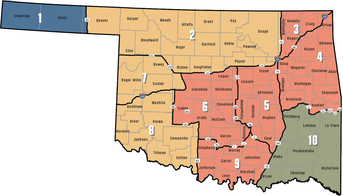
Zones from the ODWC antlerless deer zone map (county shares are a GIS overlay; the legal line is the road), ODWC elk zones, the bear area, fall turkey counties, the pheasant area, waterfowl zones, the crane area and the CWD surveillance areas; limits and baiting from the 2026-2027 Oklahoma Fishing and Hunting Regulations and ODWC turkey regulations. Checked November 3, 2026.
Enid deer harvest by season
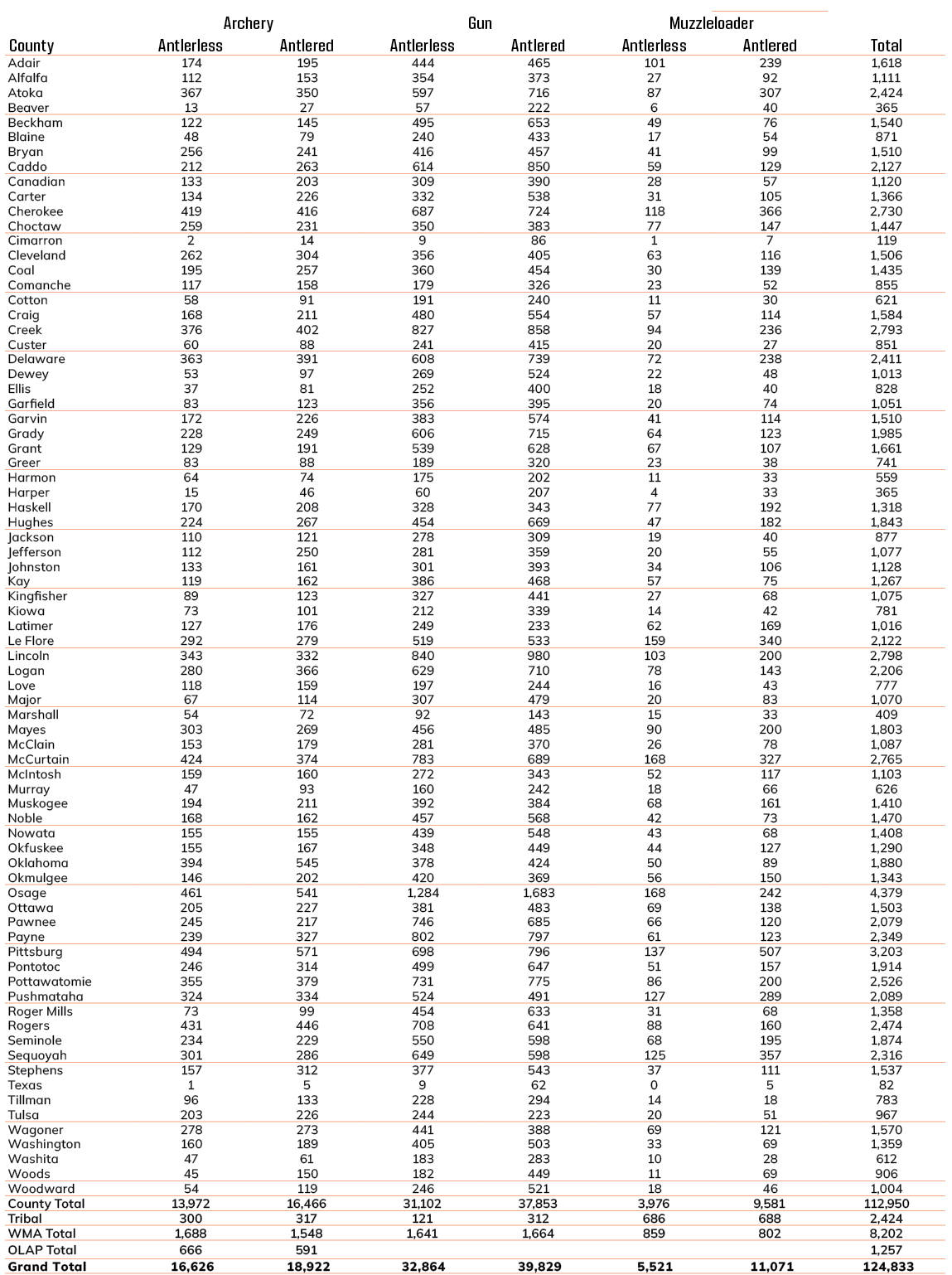
Hunters checked 1,176 deer in Garfield County in the 2025-26 season, not counting WMA deer, which ODWC reports separately. The 2024 harvest was 1,223 (down 4% since). Archery took 23% of the 2025 county harvest, gun 70%. Among ODWC-managed areas near Enid, Drummond Flats WMA led 2025 with 16 deer. Other big game checked in Garfield County in 2025: 1 elk. The 2025 Game Harvest Survey puts spring turkey at 11,232 statewide; ODWC gives no county split.
| Season | Harvest | Gun | Muzzleloader | Archery | With antlers |
|---|---|---|---|---|---|
| 2021-22 | 887 | 624 | 63 | 200 | 511 |
| 2022-23 | 1,089 | 785 | 66 | 238 | 642 |
| 2023-24 | 1,051 | 751 | 94 | 206 | 592 |
| 2024-25 | 1,223 | 902 | 69 | 252 | 683 |
| 2025-26 | 1,176 | 819 | 87 | 270 | 648 |
| Area | Deer 2024 | Deer 2025 |
|---|---|---|
| Drummond Flats WMA | 13 | 16 |
County deer harvest from the ODWC big game reports (2021, 2022, 2023, 2024, 2025); area harvest and 2025 elk, bear, mule deer and pronghorn from the 2025-26 big game harvest report; turkey from the ODWC Game Harvest Survey. Checked November 3, 2026.
Enid season calendar
40 species and 61 dated windows reach Garfield County this year; the right-hand column checks each against today.
| Species | Window | Reach | From | Through | Today? |
|---|---|---|---|---|---|
| White-tailed deer | Archery | Zone 2, 7, 8 | Oct 1, 2026 | Jan 15, 2027 | |
| White-tailed deer | Youth gun | Zone 2, 7, 8 | Oct 16, 2026 | Oct 18, 2026 | |
| White-tailed deer | Muzzleloader | Zone 2, 7, 8 | Oct 24, 2026 | Nov 1, 2026 | |
| White-tailed deer | Gun | Zone 2, 7, 8 | Nov 21, 2026 | Dec 6, 2026 | |
| White-tailed deer | Holiday antlerless | Zone 2, 7, 8 | Dec 18, 2026 | Dec 31, 2026 | |
| Mule deer | All deer seasons | Statewide | Oct 1, 2026 | Jan 15, 2027 | |
| Elk | Archery | Northwest elk zone | Oct 1, 2026 | Jan 15, 2027 | |
| Elk | Youth elk gun | Northwest elk zone | Oct 16, 2026 | Oct 18, 2026 | |
| Elk | Muzzleloader | Northwest elk zone | Oct 24, 2026 | Nov 1, 2026 | |
| Elk | Gun | Northwest elk zone | Nov 21, 2026 | Dec 6, 2026 | |
| Elk | Holiday antlerless elk | Northwest elk zone | Dec 18, 2026 | Dec 31, 2026 | |
| Wild turkey | Youth fall turkey | Open counties | Oct 16, 2026 | Oct 18, 2026 | |
| Wild turkey | Fall Gun | Open counties | Oct 31, 2026 | Nov 20, 2026 | |
| Wild turkey | Fall Archery | Statewide | Oct 1, 2026 | Jan 15, 2027 | |
| Wild turkey | Youth Spring | Statewide | Apr 10, 2027 | Apr 11, 2027 | |
| Wild turkey | Spring | Statewide | Apr 16, 2027 | May 16, 2027 | |
| Feral hogs | Private land | Private land | Jul 1, 2026 | Jun 30, 2027 | |
| Quail | Season | Statewide | Nov 14, 2026 | Feb 15, 2027 | |
| Pheasant | Season | Pheasant counties | Dec 1, 2026 | Jan 31, 2027 | |
| Rabbits | Season | Statewide | Oct 1, 2026 | Mar 15, 2027 | |
| Jackrabbit | Season | West of I-35 | Oct 1, 2026 | Mar 15, 2027 | |
| Squirrels | Season | Statewide | May 15, 2026 | Feb 28, 2027 | |
| Doves | Segment 1 | Statewide | Sep 1, 2026 | Oct 31, 2026 | |
| Doves | Segment 2 | Statewide | Dec 1, 2026 | Dec 29, 2026 | |
| Teal | September Teal | Statewide | Sep 12, 2026 | Sep 20, 2026 | |
| Ducks | Youth and veteran day | Zones 1 and 2 | Nov 7, 2026 | Nov 7, 2026 | |
| Ducks | Regular segment 1 | Zones 1 and 2 | Nov 14, 2026 | Dec 6, 2026 | |
| Ducks | Regular segment 2 | Zones 1 and 2 | Dec 12, 2026 | Jan 31, 2027 | |
| Ducks | Youth and veteran day | Zones 1 and 2 | Feb 6, 2027 | Feb 6, 2027 | |
| Canada geese | September Canada goose | Statewide | Sep 12, 2026 | Sep 21, 2026 | |
| Dark geese | Segment 1 | Statewide | Nov 7, 2026 | Dec 6, 2026 | |
| Dark geese | Segment 2 | Statewide | Dec 12, 2026 | Feb 14, 2027 | |
| Specklebellies | Segment 1 | Statewide | Nov 7, 2026 | Dec 6, 2026 | |
| Specklebellies | Segment 2 | Statewide | Dec 12, 2026 | Feb 7, 2027 | |
| Light geese | Segment 1 | Statewide | Nov 7, 2026 | Dec 6, 2026 | |
| Light geese | Segment 2 | Statewide | Dec 12, 2026 | Feb 14, 2027 | |
| Light geese | Conservation order | Statewide | Feb 15, 2027 | Mar 30, 2027 | |
| Sandhill crane | Season | West of I-35 | Oct 17, 2026 | Jan 17, 2027 | |
| Woodcock | Season | Statewide | Nov 7, 2026 | Dec 21, 2026 | |
| Coyote | Year-round | Statewide | Jul 1, 2026 | Jun 30, 2027 | |
| Bobcat | Furbearer season | Statewide | Dec 1, 2026 | Feb 28, 2027 | |
| Gray fox | Furbearer season | Statewide | Dec 1, 2026 | Feb 28, 2027 | |
| Red fox | Furbearer season | Statewide | Dec 1, 2026 | Feb 28, 2027 | |
| Raccoon | Year-round | Statewide | Jul 1, 2026 | Jun 30, 2027 | |
| Prairie dog | Year-round | Statewide | Jul 1, 2026 | Jun 30, 2027 | |
| Beaver | Year-round | Statewide | Jul 1, 2026 | Jun 30, 2027 | |
| Nutria | Year-round | Statewide | Jul 1, 2026 | Jun 30, 2027 | |
| Striped skunk | Year-round | Statewide | Jul 1, 2026 | Jun 30, 2027 | |
| Bullfrogs | Year-round | Statewide | Jul 1, 2026 | Jun 30, 2027 | |
| Rails | Season | Statewide | Sep 1, 2026 | Nov 9, 2026 | |
| Gallinules | Season | Statewide | Sep 1, 2026 | Nov 9, 2026 | |
| Snipe | Season | Statewide | Sep 26, 2026 | Jan 10, 2027 | |
| Crows | Segment 1 | Statewide | Oct 10, 2026 | Nov 16, 2026 | |
| River otter | Furbearer season | Statewide | Dec 1, 2026 | Feb 28, 2027 | |
| Badger | Furbearer season | Statewide | Dec 1, 2026 | Feb 28, 2027 | |
| Mink | Furbearer season | Statewide | Dec 1, 2026 | Feb 28, 2027 | |
| Muskrat | Furbearer season | Statewide | Dec 1, 2026 | Feb 28, 2027 | |
| Opossum | Furbearer season | Statewide | Dec 1, 2026 | Feb 28, 2027 | |
| Weasel | Furbearer season | Statewide | Dec 1, 2026 | Feb 28, 2027 | |
| Crows | Segment 2 | Statewide | Dec 9, 2026 | Mar 4, 2027 | |
| Rattlesnakes | Season | Statewide | Mar 1, 2027 | Jun 30, 2027 |
From the ODWC hunting regulations and the 2026-2027 Oklahoma Fishing and Hunting Regulations (Oklahoma Department of Wildlife Conservation), checked November 3, 2026.
Drawn hunts around Enid
Draw hunts near Enid start with Salt Plains NWR, 31 mi away. The 2026 draw window ran April 1 through May 20, 2026; elk and pronghorn are once in a lifetime. Youth categories take hunters 15 or younger on the first day of the hunt.
| Hunt area | How far | Program | Controlled hunts | Permits |
|---|---|---|---|---|
| Salt Plains NWR | 31 mi | Wildlife refuge | Deer, Motor vehicle or non-ambulatory permit deer, Youth dee | 176 |
| Sandhills WMA | 45 mi | WMA | Deer | 5 |
| Canton WRP | 45 mi | Waterfowl refuge portion | Youth deer | 4 |
| Canton WMA | 48 mi | WMA | Deer | 75 |
2025 controlled hunt results per area from the ODWC controlled hunts results (lands.json, controlled_hunts_2025); rules and dates from the ODWC controlled hunts page. Checked November 3, 2026.
Services for Enid hunters
ODWC licenses commercial hunting areas but keeps no hunting guide list, so the guide rows are preserves and directory listings. To give venison to food banks, Ed's Taxidermy & Wild Game Processing (35 mi) is a Hunters Against Hunger processor. The nearest taxidermist on the list is Wolf Creek Taxidermy, 2.7 mi from Enid. Short on shells? Champlin Firearms Inc in Enid in town. Bluestem Hunting leads the commercial hunting area and guide rows for Enid.
| Service | Within 15 mi | Within 35 mi | Nearest | Miles | Town |
|---|---|---|---|---|---|
| Processors | 0 | 2 | Rios Custom Processing | 30 mi S | Dover |
| Mounts | 3 | 7 | Wolf Creek Taxidermy | 2.7 mi SW | Enid |
| Gun and bow shops | 5 | 9 | Champlin Firearms Inc | in town | Enid |
| Preserves and guides | 0 | 1 | Bluestem Hunting | 32 mi E | Perry |
Processors
Mounts
Gun and bow shops
Preserves and guides
Processors from the ODWC game processor list (Hunters Against Hunger column) and Yellow Pages; commercial hunting areas from the ODWC commercial hunt area list; taxidermists and shops from Yellow Pages and chain store locators (services.json). Listings without coordinates are placed at their town. Checked November 3, 2026; hours were not checked.
Three range cards for Enid
Distances run from the Census point of Enid.
No dues at Canton WMA Shooting Range, 44 miles from Enid; bring a hunting or combination license. Range page
Straight-line miles from the town centre; ranges checked November 3, 2026.
Enid sunrise and sunset
ODWC prints no sunrise and sunset table, so the times here are worked out for Enid with the NOAA solar formula.
| Day | Moment | First sun | Last sun | Deer hours | Duck hours | Bird dog hours |
|---|---|---|---|---|---|---|
| Oct 1, 2026 | Archery deer opens | 7:25 a.m. | 7:16 p.m. | 6:55 a.m.–7:46 p.m. | 6:55 a.m.–7:16 p.m. | 7:25 a.m.–7:16 p.m. |
| Oct 24, 2026 | Muzzleloader opens | 7:45 a.m. | 6:45 p.m. | 7:15 a.m.–7:15 p.m. | 7:15 a.m.–6:45 p.m. | 7:45 a.m.–6:45 p.m. |
| Nov 21, 2026 | Gun deer opens | 7:14 a.m. | 5:21 p.m. | 6:44 a.m.–5:51 p.m. | 6:44 a.m.–5:21 p.m. | 7:14 a.m.–5:21 p.m. |
| Dec 6, 2026 | Gun deer closes | 7:28 a.m. | 5:16 p.m. | 6:58 a.m.–5:46 p.m. | 6:58 a.m.–5:16 p.m. | 7:28 a.m.–5:16 p.m. |
| Dec 21, 2026 | Shortest day | 7:39 a.m. | 5:19 p.m. | 7:09 a.m.–5:49 p.m. | 7:09 a.m.–5:19 p.m. | 7:39 a.m.–5:19 p.m. |
| Jan 15, 2027 | Archery closes | 7:42 a.m. | 5:38 p.m. | 7:12 a.m.–6:08 p.m. | 7:12 a.m.–5:38 p.m. | 7:42 a.m.–5:38 p.m. |
| Apr 16, 2027 | Spring turkey | 6:58 a.m. | 8:05 p.m. | 6:28 a.m.–8:35 p.m. | 6:28 a.m.–8:05 p.m. | 6:58 a.m.–8:05 p.m. |
Hours rules from the ODWC big game regulations and the 2026-2027 Oklahoma Fishing and Hunting Regulations; sunrise and sunset worked out for this location with the NOAA solar formula (Central Time); checked November 3, 2026. Legal hours for every county.
ODWC offices and game wardens for Enid
For a counter visit, the closest ODWC office to Enid is in Oklahoma City, 67 miles off. For the ODWC Central Region, the listed supervisor is Jeff Pennington, reached at (405) 650-0149. For violations near Enid, the District 8 captain is Ben Bickerstaff at (580) 304-6034. County game wardens for Garfield County answer at (580) 541-0819. Garfield County sits in Wildlife Conservation Commission District 8.
ODWC Headquarters, 67 mi
ODWC at Lawton
Offices from the ODWC offices list, game warden districts and captains from the ODWC game warden directory, region supervisors from the ODWC administrative boundaries layer, county warden phones from ODWC area pages (counties.json, services.json, lands.json). Offices without a geocoded address are measured to their town. Checked November 3, 2026.
Enid hunting FAQ
When does quail hunting end each day on OLAP land?
At 4:30 p.m., for both quail and pheasant.
Does Oklahoma limit Sunday hunting?
No; the regulations and Title 29 text read show no Sunday restriction.
Which ODWC law enforcement district includes Enid?
District 8, under Captain Ben Bickerstaff.
Where is the nearest game processor to Enid?
Rios Custom Processing, Dover, about 30 mi from Enid.
What hunting land open to the public lies next to Enid?
On the land table the first row is Drummond Flats WMA, with its closest edge 11 miles out. Behind it sits Grant County OLAP limited LA001, about 27 miles away measured to its mapped point.
What are the closest town pages to Enid?
Drummond, Medford, Nescatunga and Cleo Springs, nearest first.
How many does may I take around Enid?
By zone: Zone 2, 4 antlerless by muzzleloader and 4 by gun, plus archery and the holiday antlerless season.
Is any WMA or OLAP tract inside 10 miles of Enid?
No. Drummond Flats WMA is the closest, beyond the 10-mile mark.
Does elk hunting in Garfield County need landowner permission?
Yes. Elk zones are private land only, and you need written permission.
Do deer dates around Enid differ from the rest of Oklahoma?
No. Deer dates are statewide; only the antlerless limits change by zone, and WMAs may set their own rules.
Must an Enid hunter report before processing?
Yes. Deer, elk, pronghorn, bear and turkey are reported before processing.
How much hunter orange does Oklahoma require for gun deer?
400 square inches of daylight fluorescent orange, split between head covering and outer garment.
Can I hunt turkeys near a feeder around Enid?
Not within 100 yards of bait.
Answers from places.json, lands.json, counties.json, services.json and the 2026-2027 Oklahoma Fishing and Hunting Regulations; reporting from ODWC, hunter orange from the ODWC big game regulations, baiting from ODWC, Sunday hunting from ODWC seasons, the Land Access Permit from the ODWC license fees, CWD from ODWC. Checked November 3, 2026.
Before leaving Enid
Distances here are straight lines from Enid; every WMA, OLAP tract and federal area has its own rules, so read the land page and the 2026-27 regulations before going.
Other photos on this page: U.S. Fish & Wildlife Service Southwest Region (Public Domain Mark 1.0); Jack Gray (CC BY 2.0); Pondfishfarmer (CC BY-SA 4.0); Lane Pearman (CC BY 2.0); Guy Teague (CC BY-SA 2.0); Thomas Shahan (CC BY 2.0); Thomas & Dianne Jones (CC BY 2.0); Thesagemarmot (CC BY-SA 3.0).