Home › Oklahoma › Towns › Sand Point
Southeast Oklahoma town
Oklahoma public hunting land around Sand Point
Sand Point as a hunting base: land by distance and how to get on it, the Bryan County antlerless limits, season dates, deer harvest and businesses that take a deer.
Photo: From another corner of Bryan County (nearby stand-in). Sharon Mollerus (CC BY 2.0)
Inside Bryan County, Sand Point works as a small base for the Ouachita Mountains, the Kiamichi and Little rivers, the pine country of McCurtain and Pushmataha counties and Lake Texoma. Sand Point and Lake Texoma (U.S. Army Corps of Engineers) share a boundary. Sand Point has no town government; it is a Census-designated place, so the 2024 estimates carry no population for it. A 10-mile circle around Sand Point catches 1 listed area and about 24,742 mapped public acres. A 25-mile drive opens 10 listed areas and about 69,620 acres. For Bryan County as a whole, the GIS layers measure about 12,200 public acres, including 5 acres of national forest or grassland and 12,195 acres of Corps fee land. Top of the distance list for Sand Point: Lake Texoma (Corps), which reaches the edge of town.
Town point and land area from the Census 2024 Gazetteer; public acreage and boundary miles within 10 and 25 miles are a GIS measure over the ODWC WMA layer and USFS, USFWS, Corps and NPS boundaries (places.json; area counts are within 25 miles); OLAP tract acres from the ODWC OLAP layer. ODWC region from the ODWC administrative boundaries layer. Checked November 3, 2026.
Sand Point antlerless zones, elk zones and county rules
Oklahoma draws antlerless deer zones along roads, so public land near Sand Point can sit in another zone or county; every county with nearby land gets a row.
| County | Zone (does) | Limit ML / gun | Zone (elk) | Fall gun turkey | Notes |
|---|---|---|---|---|---|
| Bryan County town | 10, 9 | 1/1; 2/2 | Southeast | Open | Bear area (part) |
| Marshall County | 9 | 2/2 | Southeast | Open | – |
| Love County | 9 | 2/2 | Southeast, Southwest | Open | Crane, jackrabbit |
| Johnston County | 9 | 2/2 | Southeast | Open | – |
| Murray County | 9, 6 | 2/2; 2/2 | Southwest, Special Southeast | Open | Crane, jackrabbit |
Bryan County is split between antlerless zones (Zone 10 about 76%, Zone 9 about 24% of the county by GIS), along roads rather than the county line. (Zone 10, Zone 9; ODWC antlerless zone map.) Antlerless limits by zone: Zone 10: 1 antlerless by muzzleloader and 1 by gun; Zone 9: 2 antlerless by muzzleloader and 2 by gun. Oklahoma caps a hunter at six deer a season, two of them antlered at most, before holiday antlerless and controlled hunts. In Bryan County, gun deer season runs November 21 through December 6, 2026, after the muzzleloader dates of October 24 to November 1. The Southeast Zone (Private lands south of I-40 and east of I-35 (Carter/Murray east of I-35 are the Special Southeast Zone)) takes in Bryan County, with a zone quota of 5; public elk hunting comes only through controlled hunts. (Southeast Zone.) The bear area described as "Choctaw, Haskell, Latimer, Le Flore, McCurtain and Pushmataha counties; McIntosh, Muskogee and Sequoyah south of I-40; Atoka, Bryan, McIntosh and Pittsburg east of US 69" includes Bryan County. Bryan County is one of the 64 counties with a fall gun turkey season (October 31 to November 20). Bryan County ducks follow Zones 1 and 2, last day January 31, 2027. No crane or jackrabbit season in Bryan County: both are closed east of I-35. Baiting is banned on land owned or managed by ODWC, and turkeys may not be hunted within 100 yards of bait; the regulations read set no statewide private-land deer bait ban.
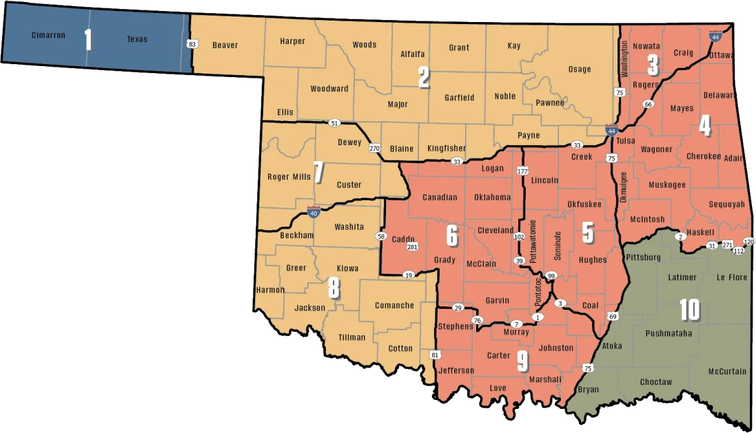
Zones from the ODWC antlerless deer zone map (county shares are a GIS overlay; the legal line is the road), ODWC elk zones, the bear area, fall turkey counties, the pheasant area, waterfowl zones, the crane area and the CWD surveillance areas; limits and baiting from the 2026-2027 Oklahoma Fishing and Hunting Regulations and ODWC turkey regulations. Checked November 3, 2026.
Where Sand Point hunters can go
Land whose boundary comes within 25 miles of Sand Point heads the table, nearest edge first; anything farther follows by miles to its mapped point.
| Area | Reach | Category | Agency | Entry rule | Acres | Note |
|---|---|---|---|---|---|---|
| Lake Texoma (Corps) page anchor | in town | Corps lake | Corps | Corps hunting areas | – | No acreage given |
| Tishomingo NWR | 12 mi N | Wildlife refuge | USFWS | Refuge hunt units | 16,136 | Controlled hunts |
| Tishomingo WMU | 16 mi N | Refuge WMU | ODWC | Refuge hunt units | 3,150 | – |
| Fobb Bottom WMA | 16 mi W | WMA | ODWC | Area rules | 2,205 | Nonresident check-in |
| Texoma-Washita Arm WMA | 18 mi NW | WMA | ODWC | Area rules | 13,286 | Nonresident check-in |
| Johnston County OLAP walk-in H005 | 18 mi NW | OLAP walk-in | ODWC lease | Land Access Permit | 150 | Grassland |
| Johnston County OLAP walk-in H004 | 19 mi NW | OLAP walk-in | ODWC lease | Land Access Permit | 350 | Grassland |
| Hickory Creek WMA | 24 mi W | WMA | ODWC | Area rules | 7,363 | Nonresident check-in |
| Love Valley WMA | 24 mi W | WMA | ODWC | Area rules | 7,746 | Layer acres differ |
| Blue River PFHA | 25 mi N | Fishing and hunting area | ODWC | Area rules | 3,367 | Nonresident check-in |
| Arbuckle Springs WMA | 34 mi N | WMA | ODWC | Area rules | 3,874 | Nonresident check-in |
| Chickasaw NRA | 43 mi NW | Recreation area | NPS | NPS limits | 4,500 | – |
| Cross Timbers WMA | 47 mi W | WMA | ODWC | Area rules | 10,547 | Nonresident check-in |
| McGee Creek WMA | 49 mi NE | WMA | ODWC | Area rules | 10,000 | Nonresident check-in |
With 16,136 acres, Tishomingo NWR gives the most room near Sand Point. Counted by type: 6 ODWC-managed areas, 2 OLAP tracts, 1 federal area and 1 lake or park area. Before a first trip to Fobb Bottom WMA, read its special regulations; a season not listed there follows the statewide rules. The area phone for hunters is (405) 823-8383. Out-of-state hunters check in for Fobb Bottom WMA first. OLAP walk-in land is open September 1 to May 16 with archery and shotguns only (no rifles, slugs or muzzleloaders); Johnston County OLAP walk-in H005 is the nearest tract. At Lake Texoma (Corps), Corps hunting areas are generally open to legal species and weapons, but not developed recreation areas or land around dams. Read the Tishomingo NWR hunt unit map and conditions before going. Love Valley WMA includes Wetland Development Units: 1 p.m. waterfowl close, no lead shot.
Short notes on public land by Sand Point
- Tishomingo NWR: 16,136 acres; species: deer, turkey, feral hog; deer in 2025: 41
- Tishomingo WMU: 3,150 acres; seasons for deer, dove, turkey, waterfowl, quail; camping is allowed in 7 designated camp sites (ODWC map)
- Fobb Bottom WMA: 2,205 acres; non-ambulatory hunting acres 696; species: deer, dove, waterfowl, turkey, quail; in designated areas only (printable map)
- Texoma-Washita Arm WMA: 13,286 acres; drive-in acres (permit) 229; listed game: deer, dove, turkey, waterfowl, quail; 2025 deer count 40; hunter and angler camping is allowed in two designated primitive camping areas offered on Texoma/Washita Arm WMA (map PDF)
- Johnston County OLAP walk-in H005: 150 acres; species: deer, turkey, dove, waterfowl; land cover: grassland, Ponds, Wetland
Lands from ODWC area pages, Public Hunting Areas special regulations and the OLAP layer, USFWS, USFS, NPS, Corps and installation records (lands.json; each land page cites its own source); 2025 deer harvest by area from the ODWC 2025-26 big game harvest report. Boundary miles from places.json, other miles to each mapped point. Area rules from the Department-Managed Area Rules. Checked November 3, 2026.
Permit hunts close to Sand Point
Controlled hunts put drawn hunters on 5 areas near Sand Point in 2025. The 2026 controlled hunt application window closed May 20, 2026. The minimum age is 14 on most hunts, 12 at a few areas and 18 at Wichita Mountains refuge.
| Area | From town | Program | Hunt types | Permits issued |
|---|---|---|---|---|
| Lake Texoma (Corps) | 5.3 mi | Corps lake | Youth deer | 14 |
| Tishomingo NWR | 16 mi | Wildlife refuge | Deer, Motor vehicle or non-ambulatory permit deer, Spring tu | 73 |
| Arbuckle Springs WMA | 34 mi | WMA | Special family deer | 25 |
| Cross Timbers WMA | 47 mi | WMA | Special family deer, Spring turkey, Youth deer | 90 |
| McGee Creek WMA | 49 mi | WMA | Deer | 65 |
2025 controlled hunt results per area from the ODWC controlled hunts results (lands.json, controlled_hunts_2025); rules and dates from the ODWC controlled hunts page. Checked November 3, 2026.
Deer checked around Sand Point
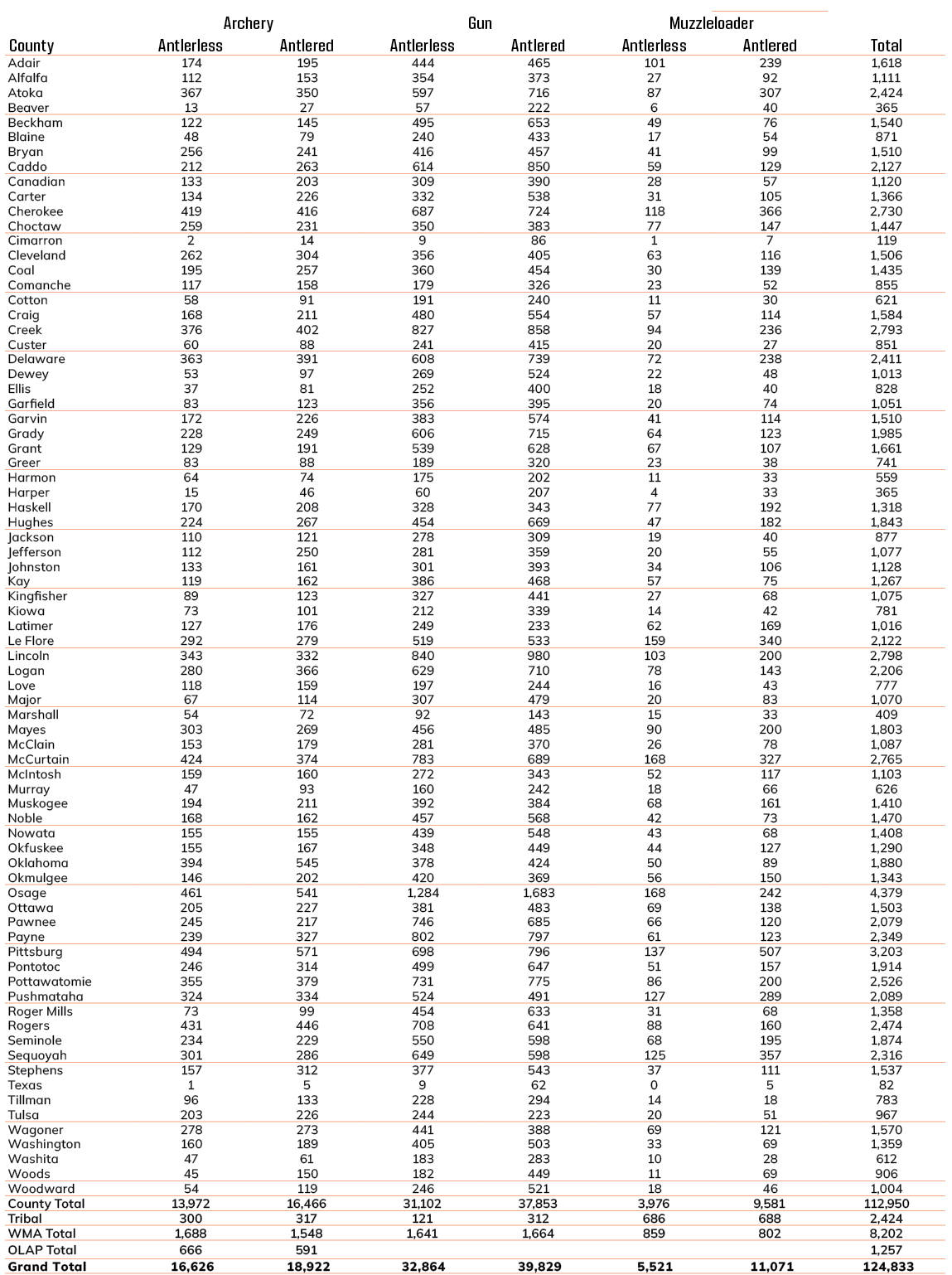
Bryan County produced 2,147 checked deer in 2025, outside the WMAs. A year earlier the figure was 1,595, so 2025 came in 35% higher. Bowhunters checked 766 deer in Bryan County that year, gun hunters 1,210. Area harvest near Sand Point peaks at Love Valley WMA, 86 deer in 2025. Turkey numbers exist only statewide: about 11,232 spring gobblers in the 2025 survey, none broken out for Bryan County.
| Season | Deer | Gun | Muzzleloader | Archery | Antlered |
|---|---|---|---|---|---|
| 2021-22 | 1,791 | 996 | 140 | 655 | 1,053 |
| 2022-23 | 1,777 | 986 | 119 | 672 | 942 |
| 2023-24 | 1,510 | 873 | 140 | 497 | 797 |
| 2024-25 | 1,595 | 994 | 83 | 518 | 788 |
| 2025-26 | 2,147 | 1,210 | 171 | 766 | 1,117 |
| Area | 2024-25 | 2025-26 |
|---|---|---|
| Tishomingo NWR | 54 | 41 |
| Texoma-Washita Arm WMA | 37 | 40 |
| Hickory Creek WMA | 36 | 35 |
| Love Valley WMA | 76 | 86 |
| Blue River PFHA | – | 57 |
County deer harvest from the ODWC big game reports (2021, 2022, 2023, 2024, 2025); area harvest and 2025 elk, bear, mule deer and pronghorn from the 2025-26 big game harvest report; turkey from the ODWC Game Harvest Survey. Checked November 3, 2026.
Sand Point ODWC and game warden contacts
From Sand Point, the nearest ODWC office is in Caddo, about 16 miles off. The ODWC Southeast Region supervisor covering Bryan County is Eric Suttles. Bryan County falls in game warden District 4; the district captain is Tom Cartwright, (580) 320-2955. Bryan County votes in Wildlife Conservation Commission District 3.
ODWC Caddo Office & Durant State Fish Hatchery, nearest to Sand Point
ODWC Higgins Office, 98 mi
Offices from the ODWC offices list, game warden districts and captains from the ODWC game warden directory, region supervisors from the ODWC administrative boundaries layer, county warden phones from ODWC area pages (counties.json, services.json, lands.json). Offices without a geocoded address are measured to their town. Checked November 3, 2026.
Sand Point 2026-27 hunting dates by species
Ducks run on Panhandle dates or Zone 1 and 2 dates, and cranes and jackrabbits only west of I-35, which is why the area column matters for Bryan County.
| Quarry | Segment | Zone or area | Begins | Ends | Open now? |
|---|---|---|---|---|---|
| White-tailed deer | Archery | Zone 10 | Oct 1, 2026 | Jan 15, 2027 | |
| White-tailed deer | Youth gun | Zone 10 | Oct 16, 2026 | Oct 18, 2026 | |
| White-tailed deer | Muzzleloader | Zone 10 | Oct 24, 2026 | Nov 1, 2026 | |
| White-tailed deer | Gun | Zone 10 | Nov 21, 2026 | Dec 6, 2026 | |
| White-tailed deer | Holiday antlerless | Zone 10 | Dec 18, 2026 | Dec 31, 2026 | |
| White-tailed deer | Archery | Zone 3, 4, 5, 6, 9 | Oct 1, 2026 | Jan 15, 2027 | |
| White-tailed deer | Youth gun | Zone 3, 4, 5, 6, 9 | Oct 16, 2026 | Oct 18, 2026 | |
| White-tailed deer | Muzzleloader | Zone 3, 4, 5, 6, 9 | Oct 24, 2026 | Nov 1, 2026 | |
| White-tailed deer | Gun | Zone 3, 4, 5, 6, 9 | Nov 21, 2026 | Dec 6, 2026 | |
| White-tailed deer | Holiday antlerless | Zone 3, 4, 5, 6, 9 | Dec 18, 2026 | Dec 31, 2026 | |
| Mule deer | All deer seasons | Statewide | Oct 1, 2026 | Jan 15, 2027 | |
| Elk | Archery | Southeast elk zone | Oct 1, 2026 | Jan 15, 2027 | |
| Elk | Youth elk gun | Southeast elk zone | Oct 16, 2026 | Oct 18, 2026 | |
| Elk | Muzzleloader | Southeast elk zone | Oct 24, 2026 | Nov 1, 2026 | |
| Elk | Gun | Southeast elk zone | Nov 21, 2026 | Dec 6, 2026 | |
| Elk | Holiday antlerless elk | Southeast elk zone | Dec 18, 2026 | Dec 31, 2026 | |
| Black bear | Archery | Bear area | Oct 1, 2026 | Oct 18, 2026 | |
| Black bear | Muzzleloader | Bear area | Oct 24, 2026 | Nov 1, 2026 | |
| Wild turkey | Youth fall turkey | Open counties | Oct 16, 2026 | Oct 18, 2026 | |
| Wild turkey | Fall Gun | Open counties | Oct 31, 2026 | Nov 20, 2026 | |
| Wild turkey | Fall Archery | Statewide | Oct 1, 2026 | Jan 15, 2027 | |
| Wild turkey | Youth Spring | Statewide | Apr 10, 2027 | Apr 11, 2027 | |
| Wild turkey | Spring | Statewide | Apr 16, 2027 | May 16, 2027 | |
| Feral hogs | Private land | Private land | Jul 1, 2026 | Jun 30, 2027 | |
| Quail | Season | Statewide | Nov 14, 2026 | Feb 15, 2027 | |
| Rabbits | Season | Statewide | Oct 1, 2026 | Mar 15, 2027 | |
| Squirrels | Season | Statewide | May 15, 2026 | Feb 28, 2027 | |
| Doves | Segment 1 | Statewide | Sep 1, 2026 | Oct 31, 2026 | |
| Doves | Segment 2 | Statewide | Dec 1, 2026 | Dec 29, 2026 | |
| Teal | September Teal | Statewide | Sep 12, 2026 | Sep 20, 2026 | |
| Ducks | Youth and veteran day | Zones 1 and 2 | Nov 7, 2026 | Nov 7, 2026 | |
| Ducks | Regular segment 1 | Zones 1 and 2 | Nov 14, 2026 | Dec 6, 2026 | |
| Ducks | Regular segment 2 | Zones 1 and 2 | Dec 12, 2026 | Jan 31, 2027 | |
| Ducks | Youth and veteran day | Zones 1 and 2 | Feb 6, 2027 | Feb 6, 2027 | |
| Canada geese | September Canada goose | Statewide | Sep 12, 2026 | Sep 21, 2026 | |
| Dark geese | Segment 1 | Statewide | Nov 7, 2026 | Dec 6, 2026 | |
| Dark geese | Segment 2 | Statewide | Dec 12, 2026 | Feb 14, 2027 | |
| Specklebellies | Segment 1 | Statewide | Nov 7, 2026 | Dec 6, 2026 | |
| Specklebellies | Segment 2 | Statewide | Dec 12, 2026 | Feb 7, 2027 | |
| Light geese | Segment 1 | Statewide | Nov 7, 2026 | Dec 6, 2026 | |
| Light geese | Segment 2 | Statewide | Dec 12, 2026 | Feb 14, 2027 | |
| Light geese | Conservation order | Statewide | Feb 15, 2027 | Mar 30, 2027 | |
| Woodcock | Season | Statewide | Nov 7, 2026 | Dec 21, 2026 | |
| Coyote | Year-round | Statewide | Jul 1, 2026 | Jun 30, 2027 | |
| Bobcat | Furbearer season | Statewide | Dec 1, 2026 | Feb 28, 2027 | |
| Gray fox | Furbearer season | Statewide | Dec 1, 2026 | Feb 28, 2027 | |
| Red fox | Furbearer season | Statewide | Dec 1, 2026 | Feb 28, 2027 | |
| Raccoon | Year-round | Statewide | Jul 1, 2026 | Jun 30, 2027 | |
| Prairie dog | Year-round | Statewide | Jul 1, 2026 | Jun 30, 2027 | |
| Beaver | Year-round | Statewide | Jul 1, 2026 | Jun 30, 2027 | |
| Nutria | Year-round | Statewide | Jul 1, 2026 | Jun 30, 2027 | |
| Striped skunk | Year-round | Statewide | Jul 1, 2026 | Jun 30, 2027 | |
| Bullfrogs | Year-round | Statewide | Jul 1, 2026 | Jun 30, 2027 | |
| Rails | Season | Statewide | Sep 1, 2026 | Nov 9, 2026 | |
| Gallinules | Season | Statewide | Sep 1, 2026 | Nov 9, 2026 | |
| Snipe | Season | Statewide | Sep 26, 2026 | Jan 10, 2027 | |
| Crows | Segment 1 | Statewide | Oct 10, 2026 | Nov 16, 2026 | |
| River otter | Furbearer season | Statewide | Dec 1, 2026 | Feb 28, 2027 | |
| Badger | Furbearer season | Statewide | Dec 1, 2026 | Feb 28, 2027 | |
| Mink | Furbearer season | Statewide | Dec 1, 2026 | Feb 28, 2027 | |
| Muskrat | Furbearer season | Statewide | Dec 1, 2026 | Feb 28, 2027 | |
| Opossum | Furbearer season | Statewide | Dec 1, 2026 | Feb 28, 2027 | |
| Weasel | Furbearer season | Statewide | Dec 1, 2026 | Feb 28, 2027 | |
| Crows | Segment 2 | Statewide | Dec 9, 2026 | Mar 4, 2027 | |
| Rattlesnakes | Season | Statewide | Mar 1, 2027 | Jun 30, 2027 |
From the ODWC hunting regulations and the 2026-2027 Oklahoma Fishing and Hunting Regulations (Oklahoma Department of Wildlife Conservation), checked November 3, 2026.
Hunting businesses around Sand Point
These are the businesses Sand Point hunters lean on each season, sorted by trade and then by distance. Whiskey Creek Processing, 15 mi off, processes donated deer for the Hunters Against Hunger program. A mount from a Sand Point hunt can go to Smitty's Taxidermy in Durant, 6.6 mi away. Three Percent Firearms and Coatings, 2.1 mi out, stocks guns, bows or outdoor gear. Pay hunts near Sand Point start with Cabin Fever Adventures, licensed by ODWC for upland game.
| Type | Inside 15 | Inside 35 | Nearest one | Distance | Town |
|---|---|---|---|---|---|
| Processing shops | 2 | 2 | Tucker's Slaughter House | 12 mi E | Durant |
| Mount makers | 2 | 3 | Smitty's Taxidermy | 6.6 mi NE | Durant |
| Outdoor stores | 5 | 8 | Three Percent Firearms and Coatings | 2.1 mi E | Mead |
| Preserves | 2 | 6 | Cabin Fever Adventures | 8.2 mi W | Kingston |
Processing shops
Mount makers
Outdoor stores
Preserves
Processors from the ODWC game processor list (Hunters Against Hunger column) and Yellow Pages; commercial hunting areas from the ODWC commercial hunt area list; taxidermists and shops from Yellow Pages and chain store locators (services.json). Listings without coordinates are placed at their town. Checked November 3, 2026; hours were not checked.
What the calendar shows near Sand Point
Inside about 30 miles, soonest first, the calendar shows 6 upcoming listings: DU chapter dinner, ODWC controlled hunt and ODWC youth draw. Checked November 3, 2026. 5 of them are ODWC controlled hunts, open only to hunters drawn in the spring.
Still on the calendar
| Days | What | Mi | Place | Go | From |
|---|---|---|---|---|---|
| Nov 5–6, 2026 | Tishomingo NWR motor vehicle deer controlled hunt | 16 | Event details | Source | |
| Nov 6–8, 2026 | Texoma COE (Burns Run) youth deer hunt | 5 | Event details | Source | |
| Nov 7–20, 2026 | Tishomingo NWR deer controlled hunt | 16 | Event details | Source | |
| Nov 13–15, 2026 | Texoma COE (Lakeside) youth deer hunt | 5 | Event details | Source | |
| Nov 17, 2026 | Bryan County Dinner – Durant · DU chapter dinner | 11 | Durant: Lost Street Brewing Company | Buy tickets | Source |
| Apr 22–23, 2027 | Tishomingo NWR spring turkey controlled hunt | 16 | Event details | Source |
Practice spots handy to Sand Point
From central Sand Point, Barrett's Outdoors is closest at 7 miles.
Straight-line miles from the town centre; ranges checked November 3, 2026.
Sand Point hunting hours
Big game legal light around Sand Point starts 30 minutes before sunrise and ends 30 minutes after sunset; ducks and geese end at sunset.
| Date | Why it matters | Sunrise | Sunset | Deer and elk | Migratory | Quail, pheasant |
|---|---|---|---|---|---|---|
| Oct 1, 2026 | Archery deer opens | 7:18 a.m. | 7:11 p.m. | 6:48 a.m.–7:41 p.m. | 6:48 a.m.–7:11 p.m. | 7:18 a.m.–7:11 p.m. |
| Oct 24, 2026 | Muzzleloader opens | 7:36 a.m. | 6:42 p.m. | 7:06 a.m.–7:12 p.m. | 7:06 a.m.–6:42 p.m. | 7:36 a.m.–6:42 p.m. |
| Nov 21, 2026 | Gun deer opens | 7:03 a.m. | 5:20 p.m. | 6:33 a.m.–5:50 p.m. | 6:33 a.m.–5:20 p.m. | 7:03 a.m.–5:20 p.m. |
| Dec 6, 2026 | Gun deer closes | 7:16 a.m. | 5:16 p.m. | 6:46 a.m.–5:46 p.m. | 6:46 a.m.–5:16 p.m. | 7:16 a.m.–5:16 p.m. |
| Dec 21, 2026 | Shortest day | 7:26 a.m. | 5:20 p.m. | 6:56 a.m.–5:50 p.m. | 6:56 a.m.–5:20 p.m. | 7:26 a.m.–5:20 p.m. |
| Jan 15, 2027 | Archery closes | 7:30 a.m. | 5:37 p.m. | 7:00 a.m.–6:07 p.m. | 7:00 a.m.–5:37 p.m. | 7:30 a.m.–5:37 p.m. |
| Apr 16, 2027 | Spring turkey | 6:54 a.m. | 7:56 p.m. | 6:24 a.m.–8:26 p.m. | 6:24 a.m.–7:56 p.m. | 6:54 a.m.–7:56 p.m. |
Hours rules from the ODWC big game regulations and the 2026-2027 Oklahoma Fishing and Hunting Regulations; sunrise and sunset worked out for this location with the NOAA solar formula (Central Time); checked November 3, 2026. Legal hours for every county.
Sand Point, answered
Who supervises game wardens in Bryan County?
Captain Tom Cartwright of District 4.
Which towns near Sand Point have their own page here?
Cumberland, Durant, Bee and Madill are the nearest four.
How far is Sand Point from the nearest public hunting ground?
The nearest listed land is Lake Texoma (Corps), which reaches the edge of town. Following that: Tishomingo NWR, with its closest edge 12 miles out.
Is there much public land close to Sand Point?
About 24,742 mapped public acres within 10 miles, in 1 area.
What are the muzzleloader and gun antlerless limits in Bryan County?
Zone 10: 1 antlerless by muzzleloader and 1 by gun; Zone 9: 2 antlerless by muzzleloader and 2 by gun.
On what date does gun deer season end near Sand Point?
December 6, 2026, with the holiday antlerless season later in December.
Which elk zone covers Bryan County?
Southeast Zone.
Is camouflage orange legal in Oklahoma?
Yes, if it adds up to 400 square inches of orange.
How long do Oklahoma hunters have to report big game?
Within 24 hours of leaving the hunt area, before processing.
Can bear be baited on a WMA near Sand Point?
No. Bear baiting is prohibited on WMAs.
Is there a Sunday hunting law in Oklahoma?
No Sunday restriction was found in the 2026-27 rules.
Can I use a rifle on OLAP walk-in land?
No. Walk-in tracts are archery and shotgun only; no rifles, slugs or muzzleloaders.
Which processor should a Sand Point hunter call first?
Tucker's Slaughter House (Durant), the closest listing at 12 mi.
Answers from places.json, lands.json, counties.json, services.json and the 2026-2027 Oklahoma Fishing and Hunting Regulations; reporting from ODWC, hunter orange from the ODWC big game regulations, baiting from ODWC, Sunday hunting from ODWC seasons, the Land Access Permit from the ODWC license fees, CWD from ODWC. Checked November 3, 2026.
Before leaving Sand Point
Distances here are straight lines from Sand Point; every WMA, OLAP tract and federal area has its own rules, so read the land page and the 2026-27 regulations before going.
Other photos on this page: Nicolas Henderson (CC BY 2.0); U.S. Fish & Wildlife Service Southwest Region (Public Domain Mark 1.0); Shiva Shenoy (CC BY 4.0); Billy Hathorn (CC BY-SA 3.0); Guy Teague (CC BY-SA 2.0); Lane Pearman (CC BY 2.0); Thomas & Dianne Jones (CC BY 2.0); Thesagemarmot (CC BY-SA 3.0).