Home › Wisconsin › Counties › Outagamie County
Northeast Wisconsin
Outagamie County Hunting
What the DNR sets for Outagamie County: deer zone and units, antlerless quota and Farmland tags, baiting status, bear zone F, turkey zone 3/2, plus harvest history and public ground.
Photo: Daniel M. Hendricks (CC BY 2.0)
The Census measures Outagamie County at 638 square miles of land; Appleton is the county seat. About 195,390 people lived there in 2024, 2.5% more than the 2020 base. Every acre falls in the Central Farmland Zone; 1 DMU cover it. Licenses and questions go to the DNR Green Bay Service Center (Green Bay), about 20 miles away. The land list holds 14 properties with ground in Outagamie County, led by Lower Wolf River Bottomlands Natural Resource Area at 3,580 acres.
Census 2024 Gazetteer and Vintage 2024 estimates (population), DNR region from the DNR staff pages, deer zones from the DNR deer zone layer, service centers from DNR office locations. Checked October 19, 2026.
Nearby
Places to hunt and shoot around Outagamie County
2026-27 deer units for Outagamie County
Across the 1 quota unit touching Outagamie County, the 2026 antlerless quotas add to 2,500 deer (whole units, not just the county share). Each archery, crossbow or gun license that names a Farmland unit here comes with 2 free antlerless authorizations, good only in that unit and on the land type you pick. Bonus tags: $12 resident, $20 nonresident, first come first served at one per day.
| Unit | Zone | 2026 antlerless quota | Bonus, public | Bonus, private | Left Oct 19 (pub/priv) | Free Farmland tags |
|---|---|---|---|---|---|---|
| Outagamie | Central Farmland | 2,500 | 600 | 1,400 | 597 / 1,381 | 2 |
Dec. 24 hunt
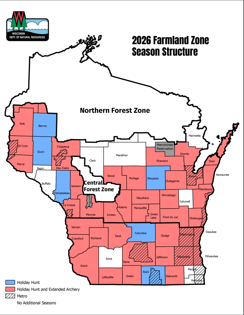
The antlerless-only Holiday Hunt runs Dec 24, 2026 to Jan 1, 2027 in Outagamie County; no bucks may be taken with any weapon on those days. Extended archery and crossbow dates: Jan 4 to Jan 31, 2027.
Gun deer opener
The nine-day gun deer season runs Nov 21 to Nov 29, 2026, followed by muzzleloader Nov 30 to Dec 9, 2026 and the statewide antlerless-only hunt Dec 10 to Dec 13, 2026.
Quotas and initial bonus counts from the DNR 2026 antlerless quota and initial permit availability (approved June 24, 2026); unsold counts and free Farmland tags from the bonus availability page as of Oct. 19, 2026; Holiday Hunt and extended archery from the 2026 season map; dates from the deer regulations. Checked October 19, 2026.
Deer harvest in Outagamie County
Deer Metrics shows 4,322 deer for the Outagamie unit in 2025, 1.3% of the state total of 345,207. Compared with 2015 (4,769 deer), 2025 was -9%, and the record year on file is 2004 (7,721).
| Season | Buck | Antlerless | Total |
|---|---|---|---|
| 2025 | 2,159 | 2,163 | 4,322 |
| 2024 | 2,207 | 2,111 | 4,318 |
| 2023 | 1,928 | 1,919 | 3,847 |
| 2022 | 1,661 | 1,962 | 3,623 |
| 2021 | 1,743 | 2,013 | 3,756 |
| 2020 | 1,728 | 2,231 | 3,959 |
| 2019 | 1,537 | 2,175 | 3,712 |
| 2018 | 1,820 | 2,421 | 4,241 |
| 2017 | 1,906 | 2,327 | 4,233 |
| 2016 | 2,017 | 2,367 | 4,384 |
Preliminary 2026 registrations
| DNR row | Bucks | Antlerless | All |
|---|---|---|---|
| Outagamie | 191 | 216 | 407 |
DNR Deer Metrics harvest history (registered deer, all seasons and weapons; values read from the DNR chart), 2025 forest DMU figures from the same source, and the DNR 2026 total harvest to date (preliminary). Checked October 19, 2026.
Outagamie County chronic wasting disease results
CWD has not been detected in wild deer from Outagamie County across 1,184 samples. Baiting deer is illegal in Outagamie County, and so is feeding them, under the CWD-related ban. Donation rule: no test needed.
| Year | Deer sampled | Positives |
|---|---|---|
| 2026 (partial) | 2 | 0 |
| 2025 | 87 | 0 |
| 2024 | 65 | 0 |
| 2023 | 81 | 0 |
| 2022 | 66 | 0 |
| 2021 | 105 | 0 |
| 2020 | 85 | 0 |
| 2019 | 45 | 0 |
| 2018 | 13 | 0 |
| 2017 | 10 | 0 |
| 2016 | 1 | 0 |
| 2015 | 2 | 0 |
CWD rules and kiosks · Which counties ban bait
CWD sampling from the DNR CWD summary by county (wild deer, data released through Oct. 18, 2026; CWD year runs April 1-March 31, 2026 partial); baiting from the DNR baiting and feeding page and its map; donation testing from the Deer Donation Program. Checked October 19, 2026.
Outagamie County: bears, gobblers and birds
Black bear
Black bear hunting here falls under zone F, drawn by preference points, with no dogs. Bear registrations in Outagamie County: 4 in 2025, 2 the year before.
| Zone | Target | Drawn 2026 | Points | Applied | 2025 state harvest | Dogs allowed |
|---|---|---|---|---|---|---|
| Zone F | 50 | 764 | 1 | 764 | 27 | No |
| Season | Harvest | Male | Female |
|---|---|---|---|
| 2025 | 4 | 4 | — |
| 2024 | 2 | 2 | — |
Turkey authorizations
The DNR turkey map places Outagamie County in zone 3 (56%) and 2 (44%). Levels below are 2025, the latest published. 2025 spring authorization total for zone 3/2: 106,668.
| Turkey zone | 2021 | 2022 | 2023 | 2024 | 2025 | Success 2025 | Birds 2025 |
|---|---|---|---|---|---|---|---|
| Zone 3 | 52,304 | 52,068 | 52,808 | 53,441 | 55,612 | 22% | 12,324 |
| Zone 2 | 51,022 | 51,028 | 51,030 | 51,065 | 51,056 | 22% | 11,024 |
Small game and birds
Ruffed grouse Zone A runs Sep 12, 2026 to Jan 3, 2027 with a daily bag of 5. 1 property in Outagamie County is on the 2026 pheasant stocking list.
Bear zones from the DNR bear zone layer; targets, permits and points from the 2026 bear drawing summary; harvest from the DNR 2025 bear report and 2024 report; turkey levels from the DNR turkey reports (2025 levels; 2027 not yet published); elk from the DNR elk page; bird zones from the DNR zone layers. Checked October 19, 2026.
Outagamie County public properties with acreage
Outagamie County counts 14 public properties open to hunting; posted refuges and closed parcels inside them still apply. MFL open lands, private forests the public may hunt, cover 45 acres here. Leased private land adds more: 0 VPA-HIP properties and 3 THAP turkey leases in Outagamie County.
- State wildlife areas (7 here)Lower Wolf River Bottomlands Natural Resource Area (3,580 ac*), Wolf River Bottoms Wildlife Area – La Sage Unit (3,138 ac*), Mack Wildlife Area (1,831 ac), Deer Creek Wildlife Area (1,488 ac*), Outagamie Wildlife Area (942 ac), Maine Wildlife Area (674 ac), Wolf River-Spoehrs Marsh Fishery Area (Remnant) (137 ac)
- State natural areas: 4Hortonville Bog State Natural Area (769 ac), Deer Creek Tamarack Bog State Natural Area (293 ac), Shaky Lake State Natural Area (221 ac), LaSage Bottoms State Natural Area (125 ac)
- State fishery areas in the county (2)Wolf River-Hortonville Flats Fishery Area (Remnant) (54 ac), DeWolfe Unit, Rueden's & Locker's Bayous
- Demonstration forest, 1 listedHeath Van Handel Memorial Forest (38 ac)
Larger units with ground here: DNR Statewide Habitat Areas (unnamed parcels), DNR Gift Lands, DNR Scattered Forest Lands.
Beyond the line: Wolf River Bottoms State Natural Area (14 miles, 50 ac), Wolf River Fishery Area (15 miles, 205 ac), Highway K Woods State Natural Area (16 miles, 32 ac).
Skip Wolf River Public Access; DNR lists no hunting there.
Every public property · About MFL open land · Turkey access leases
Public land from the DNR managed lands layer and property pages, DNR state natural area, county forest and federal records; county forest acres from the DNR county forest acreage report (July 1, 2021); MFL open acres from the DNR MFL report; leases from the DNR VPA-HIP and THAP lists. Acres within 10 miles of the county seat are a GIS measure. Checked October 19, 2026.
Every Outagamie County season on one table
Private and public land share these dates. A state park, refuge or Fort McCoy can close sooner, so read the property page before you go.
| Animal | Segment | Scope | Starts | Ends | Open now? |
|---|---|---|---|---|---|
| White-tailed deer | Archery and crossbow | Statewide | Sep 12, 2026 | Jan 3, 2027 | |
| White-tailed deer | Youth and disabled gun deer hunt | Statewide | Oct 10, 2026 | Oct 11, 2026 | |
| White-tailed deer | Gun deer (9-day) | Statewide | Nov 21, 2026 | Nov 29, 2026 | |
| White-tailed deer | Muzzleloader | Statewide | Nov 30, 2026 | Dec 9, 2026 | |
| White-tailed deer | Statewide antlerless-only (December 4-day hunt) | Statewide | Dec 10, 2026 | Dec 13, 2026 | |
| White-tailed deer | Antlerless-only Holiday Hunt | Holiday Hunt: Outagamie | Dec 24, 2026 | Jan 1, 2027 | |
| White-tailed deer | Extended archery and crossbow | Extended archery | Jan 4, 2027 | Jan 31, 2027 | |
| Black bear | Bear (Class A license by drawing) | Bear Zone F | Sep 9, 2026 | Oct 13, 2026 | |
| Wild turkey | Fall turkey | Turkey Zone 3/2 | Sep 12, 2026 | Jan 3, 2027 | |
| Wild turkey | Spring youth turkey hunt | Turkey Zone 3/2 | Apr 17, 2027 | Apr 18, 2027 | |
| Wild turkey | Spring turkey Period A | Turkey Zone 3/2 | Apr 21, 2027 | Apr 27, 2027 | |
| Wild turkey | Spring turkey Period B | Turkey Zone 3/2 | Apr 28, 2027 | May 4, 2027 | |
| Wild turkey | Spring turkey Period C | Turkey Zone 3/2 | May 5, 2027 | May 11, 2027 | |
| Wild turkey | Spring turkey Period D | Turkey Zone 3/2 | May 12, 2027 | May 18, 2027 | |
| Wild turkey | Spring turkey Period E | Turkey Zone 3/2 | May 19, 2027 | May 25, 2027 | |
| Wild turkey | Spring turkey Period F | Turkey Zone 3/2 | May 26, 2027 | Jun 1, 2027 | |
| Ruffed Grouse | Ruffed grouse | Grouse Zone A | Sep 12, 2026 | Jan 3, 2027 | |
| Pheasant | Pheasant | Statewide | Oct 17, 2026 | Jan 3, 2027 | |
| Bobwhite Quail | Bobwhite quail | Statewide | Oct 17, 2026 | Dec 9, 2026 | |
| Hungarian partridge | Hungarian partridge | Statewide | Oct 17, 2026 | Jan 3, 2027 | |
| Squirrel | Squirrel | Statewide | Sep 12, 2026 | Feb 28, 2027 | |
| Cottontail | Cottontail rabbit | Northern cottontail zone | Sep 12, 2026 | Feb 28, 2027 | |
| Cottontail | Cottontail rabbit | Southern cottontail zone | Oct 17, 2026 | Feb 28, 2027 | |
| Snowshoe Hare | Snowshoe hare | Statewide | Year-round | Year-round | Year-round |
| American Crow | Crow | Statewide | Nov 21, 2026 | Mar 24, 2027 | |
| Ducks | Youth waterfowl hunt | Statewide | Sep 19, 2026 | Sep 20, 2026 | |
| Ducks | Regular duck | Northern Duck Zone | Sep 26, 2026 | Nov 24, 2026 | |
| Ducks | Regular duck (split 1) | Southern Duck Zone | Oct 3, 2026 | Oct 11, 2026 | |
| Ducks | Regular duck (split 2) | Southern Duck Zone | Oct 17, 2026 | Dec 6, 2026 | |
| Teal | Early teal | Statewide | Sep 1, 2026 | Sep 9, 2026 | |
| Geese | Regular goose | Northern Goose Zone | Sep 16, 2026 | Dec 16, 2026 | |
| Geese | Regular goose (split 1) | Southern Goose Zone | Sep 16, 2026 | Oct 11, 2026 | |
| Geese | Regular goose (split 2) | Southern Goose Zone | Oct 17, 2026 | Dec 6, 2026 | |
| Geese | Regular goose (holiday split) | Southern Goose Zone | Dec 19, 2026 | Jan 2, 2027 | |
| Canada goose | Early Canada goose | Statewide | Sep 1, 2026 | Sep 15, 2026 | |
| Raccoon | Raccoon (resident) | Statewide | Oct 17, 2026 | Feb 15, 2027 | |
| Raccoon | Raccoon (nonresident) | Statewide | Oct 31, 2026 | Feb 15, 2027 | |
| Red and gray fox | Fox (red and gray) | Statewide | Oct 17, 2026 | Feb 15, 2027 | |
| Coyote | Coyote (hunting) | Statewide | Year-round | Year-round | Year-round |
| Bobcat | Bobcat Period 1 (hunting and trapping) | Northern Zone (State Hwy. 64 line) | Oct 17, 2026 | Dec 25, 2026 | |
| Bobcat | Bobcat Period 1 (hunting and trapping) | Southern Zone (State Hwy. 64 line) | Oct 17, 2026 | Dec 25, 2026 | |
| Bobcat | Bobcat Period 2 (hunting and trapping) | Northern Zone (State Hwy. 64 line) | Dec 26, 2026 | Jan 31, 2027 | |
| Bobcat | Bobcat Period 2 (hunting and trapping) | Southern Zone (State Hwy. 64 line) | Dec 26, 2026 | Jan 31, 2027 | |
| Unprotected species | Unprotected species (opossum, skunk, weasel, woodchuck, porcupine, starling, English sparrow, chukar, coturnix quail, etc.) | Statewide | Year-round | Year-round | Year-round |
From the Wisconsin Department of Natural Resources Fall 2026-Spring 2027 hunting regulations and season dates, checked October 19, 2026.
Towns of Outagamie County, then its neighbours
Public acres beside each Outagamie County town are a GIS total for a 10-mile circle, not a DNR figure.
- Appletoncourthouse town · 75,344 inhabitants · 727 public acres within 10 miles
- Dale11,116 public acres within 10 miles
- Hortonville3,331 inhabitants · 8,574 public acres within 10 miles
- Shiocton932 inhabitants · 10,054 public acres within 10 miles
- Howardpartly in county · 21,961 inhabitants · 2,028 public acres within 10 miles
Outagamie County borders 5 Wisconsin counties.
Towns: Census 2024 Gazetteer and Vintage 2024 estimates; adjacency from the Census county adjacency file.
Hunting hours for Outagamie County
Big game and small game hunters get 20 minutes after sunset in Wisconsin, not 30. Waterfowl and spring gobbler hunters quit at sunset.
| When | Event | North | South |
|---|---|---|---|
| Sep 12, 2026 | Archery, fall turkey and grouse opener | 5:59 a.m. to 7:31 p.m. | 6:01 a.m. to 7:30 p.m. |
| Oct 17, 2026 | Pheasant and duck dates | 6:43 a.m. to 6:25 p.m. | 6:42 a.m. to 6:28 p.m. |
| Nov 1, 2026 | Early November | 6:04 a.m. to 5:01 p.m. | 6:01 a.m. to 5:05 p.m. |
| Nov 21, 2026 | Gun deer opener | 6:32 a.m. to 4:38 p.m. | 6:27 a.m. to 4:44 p.m. |
| Dec 1, 2026 | Muzzleloader week | 6:44 a.m. to 4:32 p.m. | 6:39 a.m. to 4:39 p.m. |
| Dec 24, 2026 | Holiday Hunt opener | 7:03 a.m. to 4:34 p.m. | 6:57 a.m. to 4:42 p.m. |
| Jan 3, 2027 | Archery close (most units) | 7:05 a.m. to 4:43 p.m. | 6:59 a.m. to 4:50 p.m. |
Deer, bear, elk, small game and fall turkey table times from the Wisconsin Department of Natural Resources shooting hours tables, plus the Zone B offset of 4 minutes for longitude 88.46 W, checked October 19, 2026. Shooting hours for every county.
Before you burn in Outagamie County
The Wisconsin burn ban page shows Outagamie County today.
- Burn permit: Within DNR forest fire protection areas, whenever the ground is not completely snow-covered.
- Counties outside DNR burning-permit authority (per DNR daily restrictions on 2026-10-27): Outagamie County is on this list.
- Burn bans come from: The Wisconsin DNR, through daily county burning restrictions and permit suspensions within its forest fire protection areas (NR 30.05 emergency burning regulations; NR 45.07(3) emergency use and burning rules on DNR lands by posted notice).
- Public land fires: DNR-managed lands (NR 45.07): no fire on the ground and no burning refuse except in designated fireplaces or fire rings.
Outagamie County gun ranges and clubs
12 ranges listed inside Outagamie County, J & H Hunt Club, Outagamie Conservation Club and Shiocton Shooting Range among them on the DNR public range map.
sporting clays, shotgun on file
archery, trap, shotgun, 3D archery on file
rifle, handgun, archery on file
rifle, archery, trap, sporting clays, shotgun on file
archery, 3D archery on file
archery, 3D archery on file
| Facility | Where | Lines | Entry rule |
|---|---|---|---|
| Black Creek Sportsman's Club · trap and skeet club | Black Creek | trap/shotgun | Members only |
| Genesis Impact Sports · outdoor range | Appleton | Access not stated | |
| J & H Game Farm · sporting clays course | Shiocton | sporting clays/shotgun | Access not stated |
| Kaukauna Sportsmen's Club · rod and gun club | Kaukauna | trap/rifle/handgun/smallbore rimfire/muzzleloader/shotgun | Members only |
| Midwest Shooting Center Appleton · indoor range | Appleton | Access not stated | |
| Oneida Sportsmans Club · rod and gun club | Oneida | shotgun/rifle/handgun/smallbore rimfire/archery/muzzleloader/air gun | Members only |
On the local calendar
| Day and event | Discipline | Enter |
|---|---|---|
| Nov 1, 2026: Pre Hunters Gun Show | Gun show | See listing |
| Feb 6, 2027: 12th Annual Hortonville Archery Tournament | NASP | See listing |
Ranges from the DNR public range map and directory listings, checked October 19, 2026.
Butchers, mounts and stores near Outagamie County
Wisconsin publishes no list of licensed taxidermists or guides, so those rows come from DNR CWD partners and directories.
DNR counters and field offices
Weekday counter hours at DNR service centers run 8:30 a.m. to 4 p.m.
Processors nearby
Taxidermy shops
Guides nearby
Sporting goods
DNR service centers and field offices from DNR office locations; processors from the Deer Donation Program list, DNR CWD sampling station partners and directory listings; shops from the DNR license agent layer and directories. Checked October 19, 2026; call ahead. All Wisconsin hunting services.
Outagamie County on the Wisconsin events calendar
On file here: 4 upcoming events (DU dinner, NWTF banquet and WWA fundraiser).
Scheduled
| On | Event | Where held | Sign-up | Found at |
|---|---|---|---|---|
| Nov 5, 2026 | Fox River Valley Ducks Unlimited Banquet / DU dinner | Van Abel's of Hollandtown Kaukauna Outagamie Co. | Buy tickets | Source |
| Feb 25, 2027 | 42nd Annual Appleton Valley Chapter Banquet / WWA fundraiser | Romy’s Nitingale Black Creek Outagamie Co. | Event details | Source |
| Mar 13, 2027 | Winnebago Strutters NWTF Banquet / NWTF banquet | Appleton Outagamie Co. | Buy tickets | Source |
| May 25, 2027 | Grand Chute Gobblers NWTF Banquet / NWTF banquet | Appleton Outagamie Co. | Buy tickets | Source |
Outagamie County hunters often ask
Where do hunters in Outagamie County take deer for cutting?
Commonly Haen Meat Packing/The Meat Block, Radtke's Little River Meats and Hickory Hills Country Meats; call ahead in November.
Does extended archery apply in Outagamie County?
Yes, to Jan 31, 2027.
Does Outagamie County have more than one deer unit?
No, one unit: Outagamie.
Where do I see the bonus tags left in Outagamie County?
On the DNR bonus availability page; this page shows the counts as of Oct. 19, 2026.
What was the best deer year in Outagamie County?
2004, with 7,721 deer registered.
Is CWD testing free for deer from Outagamie County?
Yes. DNR testing is voluntary and free statewide, at kiosks, cooperating businesses or with a home kit.
Can I hunt over a food plot in Outagamie County?
Yes. Standing crops and food plots are legal, but you may not plant one on DNR land.
Can I hunt bears with hounds in Outagamie County?
No; hounds are not allowed in this zone.
Can turkeys be hunted in the fall in Outagamie County?
Yes: Sep 12, 2026 to Jan 3, 2027, using a fall authorization for the zone.
Where should I start on public land in Outagamie County?
Try the biggest first: Lower Wolf River Bottomlands Natural Resource Area, Wolf River Bottoms Wildlife Area – La Sage Unit and Mack Wildlife Area.
Answers from the DNR Fall 2026-Spring 2027 regulations, registration rules, blaze orange rules, DNR harvest and CWD data and the sources cited above. Checked October 19, 2026.
Heading to Outagamie County
Every date here is for the 2026-27 Wisconsin seasons; check the DNR site again before the trip.
Sources: DNR Fall 2026-Spring 2027 hunting regulations, season dates, Wisconsin DNR hunting, Census and the agencies linked in each section. Checked October 19, 2026.
Other photos on this page: Anne Marie Peterson from Madison, WI, US (CC BY-SA 2.0); Susan Young (Public Domain Mark 1.0); royal_broil (CC BY-SA 2.0); Doc Searls from Santa Barbara, USA (CC BY 2.0); Greg Gilbert (CC BY 2.0); U.S. Geological Survey (CC0 1.0); Danielle Brigida (CC BY 2.0).