Home › Wisconsin › Counties › Vilas County
2026-27 · Northern Forest
Vilas County Hunting
Registered deer since 1960, CWD sampling since 2015, bear and turkey figures, wildlife areas and county forest acres, and the season dates that reach Vilas County this fall and next spring.
Photo: wackybadger (CC BY-SA 2.0)
Vilas County spans 858 square miles in the Northwoods, governed from Eagle River. The Census Vintage 2024 estimate is 23,948 residents (+3.9% since 2020). The Northern Forest Zone takes in the entire county, carved into 6 units. The closest DNR counter is the DNR Woodruff Service Center in Woodruff. Vilas County touches 3 state wildlife areas, 25 state natural areas and 15 other public properties.
Census 2024 Gazetteer and Vintage 2024 estimates (population), DNR region from the DNR staff pages, deer zones from the DNR deer zone layer, service centers from DNR office locations. Checked October 19, 2026.
Nearby
Places to hunt and shoot around Vilas County
Vilas County: units, quotas, Holiday Hunt
Natural Resources Board quotas for 2026 total 2,440 antlerless deer in the units listed here. No free tags come with forest units such as DMU 116, DMU 117 and DMU 120; hunters buy bonus antlerless authorizations instead (none in DMU 116). Remaining bonus authorizations stay on sale at $12 for residents and $20 for visitors until the unit sells out.
| DMU | Zone | Quota 2026 | Public bonus | Private bonus | Unsold Oct 19 | Farmland tags per license |
|---|---|---|---|---|---|---|
| DMU 116 | Northern Forest | 0 | 0 | 0 | 0 / 0 | — |
| DMU 117 | Northern Forest | 550 | 1,000 | 1,100 | 620 / 619 | — |
| DMU 120 | Northern Forest | 545 | 500 | 1,800 | 124 / 1,163 | — |
| DMU 121 | Northern Forest | 695 | 1,500 | 2,000 | 73 / 864 | — |
| DMU 122 | Northern Forest | 330 | 600 | 1,000 | 63 / 562 | — |
| DMU 124 | Northern Forest | 320 | 650 | 800 | 0 / 123 | — |
Late seasons
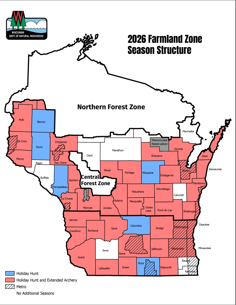
No Holiday Hunt in Vilas County: it is a Farmland-only season.
Gun season
Gun deer opens the Saturday before Thanksgiving: Nov 21 to Nov 29, 2026. Muzzleloader follows Nov 30 to Dec 9, 2026, then four antlerless-only days Dec 10 to Dec 13, 2026.
Quotas and initial bonus counts from the DNR 2026 antlerless quota and initial permit availability (approved June 24, 2026); unsold counts and free Farmland tags from the bonus availability page as of Oct. 19, 2026; Holiday Hunt and extended archery from the 2026 season map; dates from the deer regulations. Checked October 19, 2026.
Vilas County registered deer by year
Deer Metrics has no Vilas unit; the Northern Forest DMUs that cover the county were redrawn in 2025, so only 2025 figures exist for them.
DMU totals for 2025
| DMU | Bucks | Antlerless | All |
|---|---|---|---|
| DMU 116 | 917 | 301 | 1,218 |
| DMU 117 | 523 | 372 | 895 |
| DMU 120 | 726 | 429 | 1,155 |
| DMU 121 | 1,001 | 614 | 1,615 |
| DMU 122 | 472 | 330 | 802 |
| DMU 124 | 857 | 369 | 1,226 |
This fall so far (preliminary)
| Unit | Antlered | Antlerless | So far |
|---|---|---|---|
| DMU 116 | 105 | 8 | 113 |
| DMU 117 | 54 | 51 | 105 |
| DMU 120 | 62 | 48 | 110 |
| DMU 121 | 122 | 91 | 213 |
| DMU 122 | 54 | 37 | 91 |
| DMU 124 | 55 | 48 | 103 |
DNR Deer Metrics harvest history (registered deer, all seasons and weapons; values read from the DNR chart), 2025 forest DMU figures from the same source, and the DNR 2026 total harvest to date (preliminary). Checked October 19, 2026.
Vilas County CWD sampling and bait rules
Chronic wasting disease has turned up in Vilas County: 2 positive wild deer out of 3,270 sampled through Oct. 18, 2026. Sampling in CWD year 2025 reached 221 deer, with 0 positives. Hunters in Vilas County may not bait deer; the county is on the DNR ban map. Adult deer given to the program must be tested.
| CWD year | Tested | CWD found |
|---|---|---|
| 2026 (partial) | 31 | 0 |
| 2025 | 221 | 0 |
| 2024 | 272 | 1 |
| 2023 | 234 | 0 |
| 2022 | 292 | 0 |
| 2021 | 214 | 1 |
| 2020 | 184 | 0 |
| 2019 | 175 | 0 |
| 2018 | 296 | 0 |
| 2017 | 106 | 0 |
| 2016 | 75 | 0 |
CWD across Wisconsin · Feeding rules
CWD sampling from the DNR CWD summary by county (wild deer, data released through Oct. 18, 2026; CWD year runs April 1-March 31, 2026 partial); baiting from the DNR baiting and feeding page and its map; donation testing from the Deer Donation Program. Checked October 19, 2026.
Other game in Vilas County
Bear zone and harvest
The DNR bear map puts Vilas County in zone B (82%) and A (18%); zone B/A permits hounds. Vilas County ranked 22nd for bears in 2025 with 70 registered.
| Bear zone | 2026 goal | Winners | Low points | Applicants | Taken 2025 | Hounds |
|---|---|---|---|---|---|---|
| Zone B | 850 | 1,545 | 11 | 5,071 | 841 | Yes |
| Zone A | 1,100 | 1,675 | 11 | 11,648 | 1,161 | Yes |
| Year | Bears | Males | Females |
|---|---|---|---|
| 2025 | 70 | 41 | 29 |
| 2024 | 88 | 43 | 45 |
Gobblers
Spring gobbler hunting here uses zone 7 authorizations, by period A through F. Zone 7 carried 4,401 spring authorizations in 2025.
| Zone | 2021 | 2022 | 2023 | 2024 | 2025 | 2025 success | Harvest |
|---|---|---|---|---|---|---|---|
| Zone 7 | 4,396 | 4,400 | 4,400 | 4,406 | 4,401 | 16% | 726 |
Ducks, geese, grouse, rabbits
Grouse hunters here follow Zone A: Sep 12, 2026 to Jan 3, 2027.
Bear zone map and dates · Turkey zones 1 to 7
Bear zones from the DNR bear zone layer; targets, permits and points from the 2026 bear drawing summary; harvest from the DNR 2025 bear report and 2024 report; turkey levels from the DNR turkey reports (2025 levels; 2027 not yet published); elk from the DNR elk page; bird zones from the DNR zone layers. Checked October 19, 2026.
Vilas County: state, county and federal land
43 public properties in Vilas County are pinned on the map, with 0 more just over the line. County forest land here totals 41,151 acres (DNR acreage report, July 1, 2021). Open MFL acreage in Vilas County: 14,134, per the 2026 DNR report.
- National forest ranger districts (2)Eagle River-Florence Ranger District (Chequamegon-Nicolet National Forest) (319,429 acres*), Medford-Park Falls Ranger District (Chequamegon-Nicolet National Forest) (281,708 acres*)
- State forests, 3 listedNorthern Highland-American Legion State Forest (237,127 acres*), Northern Highland State Forest (176,094 acres*), American Legion State Forest (61,014 acres*)
- County forest (1)Vilas County Forest (41,151 acres)
- 25 state natural areasToy Lake Swamp State Natural Area (2,308 acres*), Johnson Lake Barrens and Springs State Natural Area (1,130 acres), Lost Canoe State Natural Area (1,119 acres), Devine Lake and Mishonagon Creek State Natural Area (1,088 acres), Bittersweet Lakes State Natural Area (1,070 acres), Dunn Lake State Natural Area (954 acres), Lake Laura Hardwoods State Natural Area (852 acres), Aurora Lake State Natural Area (831 acres), Plum Lake Hemlock Forest State Natural Area (747 acres), Nixon Lake State Natural Area (737 acres), Papoose Creek Pines State Natural Area (563 acres), Rice Creek State Natural Area (435 acres), Van Vliet Hemlocks State Natural Area (412 acres), Allequash Lake and Pines State Natural Area (398 acres), Spruce Grouse Swamp State Natural Area (396 acres), Lake Alva Birch-Hemlock State Natural Area (314 acres), Patterson Hemlocks State Natural Area (304 acres*), Camp Lake and Pines State Natural Area (211 acres), Day Lake State Natural Area (209 acres), Upper Buckatabon Springs State Natural Area (120 acres), Nell Lake State Natural Area (117 acres), Trout River State Natural Area (108 acres), Mary Lake State Natural Area (51 acres), Trout Lake Conifer Swamp State Natural Area (22 acres), Black Tern Bog State Natural Area (20 acres)
- State wildlife areas (3)Powell Marsh Wildlife Area (4,342 acres*), Spring Lake State Habitat Area (122 acres), Stateline Lake State Habitat Area (1 acres)
- State fishery areas, 9 listedTamarack Rearing Station (170 acres), Lac Vieux Desert State Public Access (67 acres), Big Sand Lake Vilas State Public Access (11 acres), Big Crawling Stone Public Access (2 acres), Conover Rearing Station (2 acres), Little Crawling Stone Lake Public Access (2 acres), Big St Germain Public Access (1 acres), Brandy Lake Public Access (1 acres), White Sand Lake Public Access (1 acres)
Also covering part of the county: Natural Area – Dedication, Wisconsin Forest Legacy Program Easements (unnamed tracts), DNR Small Public Access and Stream Bank Parcels Open to Hunting, DNR State-Owned Islands, DNR Scattered Forest Lands, Chequamegon-Nicolet National Forest.
Public land index · About county forests · MFL lands
Public land from the DNR managed lands layer and property pages, DNR state natural area, county forest and federal records; county forest acres from the DNR county forest acreage report (July 1, 2021); MFL open acres from the DNR MFL report; leases from the DNR VPA-HIP and THAP lists. Acres within 10 miles of the county seat are a GIS measure. Checked October 19, 2026.
Vilas County: opening and closing days
From bear baiting in September to the last spring turkey period, 38 season segments apply to Vilas County.
| Species | Hunt type | Zone or unit | Opening | Closing | Now |
|---|---|---|---|---|---|
| White-tailed deer | Archery and crossbow | Statewide | Sep 12, 2026 | Jan 3, 2027 | |
| White-tailed deer | Youth and disabled gun deer hunt | Statewide | Oct 10, 2026 | Oct 11, 2026 | |
| White-tailed deer | Gun deer (9-day) | Statewide | Nov 21, 2026 | Nov 29, 2026 | |
| White-tailed deer | Muzzleloader | Statewide | Nov 30, 2026 | Dec 9, 2026 | |
| White-tailed deer | Statewide antlerless-only (December 4-day hunt) | Statewide | Dec 10, 2026 | Dec 13, 2026 | |
| Black bear | Bear (Class A license by drawing) | Bear Zone B/A | Sep 9, 2026 | Sep 15, 2026 | |
| Black bear | Bear (Class A license by drawing) | Bear Zone B/A | Sep 16, 2026 | Oct 6, 2026 | |
| Black bear | Bear (Class A license by drawing) | Bear Zone B/A | Oct 7, 2026 | Oct 13, 2026 | |
| Wild turkey | Fall turkey | Turkey Zone 7 | Sep 12, 2026 | Jan 3, 2027 | |
| Wild turkey | Spring youth turkey hunt | Turkey Zone 7 | Apr 17, 2027 | Apr 18, 2027 | |
| Wild turkey | Spring turkey Period A | Turkey Zone 7 | Apr 21, 2027 | Apr 27, 2027 | |
| Wild turkey | Spring turkey Period B | Turkey Zone 7 | Apr 28, 2027 | May 4, 2027 | |
| Wild turkey | Spring turkey Period C | Turkey Zone 7 | May 5, 2027 | May 11, 2027 | |
| Wild turkey | Spring turkey Period D | Turkey Zone 7 | May 12, 2027 | May 18, 2027 | |
| Wild turkey | Spring turkey Period E | Turkey Zone 7 | May 19, 2027 | May 25, 2027 | |
| Wild turkey | Spring turkey Period F | Turkey Zone 7 | May 26, 2027 | Jun 1, 2027 | |
| Ruffed Grouse | Ruffed grouse | Grouse Zone A | Sep 12, 2026 | Jan 3, 2027 | |
| Pheasant | Pheasant | Statewide | Oct 17, 2026 | Jan 3, 2027 | |
| Bobwhite Quail | Bobwhite quail | Statewide | Oct 17, 2026 | Dec 9, 2026 | |
| Hungarian partridge | Hungarian partridge | Statewide | Oct 17, 2026 | Jan 3, 2027 | |
| Squirrel | Squirrel | Statewide | Sep 12, 2026 | Feb 28, 2027 | |
| Cottontail | Cottontail rabbit | Northern cottontail zone | Sep 12, 2026 | Feb 28, 2027 | |
| Snowshoe Hare | Snowshoe hare | Statewide | Year-round | Year-round | Year-round |
| American Crow | Crow | Statewide | Nov 21, 2026 | Mar 24, 2027 | |
| Ducks | Youth waterfowl hunt | Statewide | Sep 19, 2026 | Sep 20, 2026 | |
| Ducks | Regular duck | Northern Duck Zone | Sep 26, 2026 | Nov 24, 2026 | |
| Teal | Early teal | Statewide | Sep 1, 2026 | Sep 9, 2026 | |
| Geese | Regular goose | Northern Goose Zone | Sep 16, 2026 | Dec 16, 2026 | |
| Canada goose | Early Canada goose | Statewide | Sep 1, 2026 | Sep 15, 2026 | |
| Raccoon | Raccoon (resident) | Statewide | Oct 17, 2026 | Feb 15, 2027 | |
| Raccoon | Raccoon (nonresident) | Statewide | Oct 31, 2026 | Feb 15, 2027 | |
| Red and gray fox | Fox (red and gray) | Statewide | Oct 17, 2026 | Feb 15, 2027 | |
| Coyote | Coyote (hunting) | Statewide | Year-round | Year-round | Year-round |
| Bobcat | Bobcat Period 1 (hunting and trapping) | Northern Zone (State Hwy. 64 line) | Oct 17, 2026 | Dec 25, 2026 | |
| Bobcat | Bobcat Period 1 (hunting and trapping) | Southern Zone (State Hwy. 64 line) | Oct 17, 2026 | Dec 25, 2026 | |
| Bobcat | Bobcat Period 2 (hunting and trapping) | Northern Zone (State Hwy. 64 line) | Dec 26, 2026 | Jan 31, 2027 | |
| Bobcat | Bobcat Period 2 (hunting and trapping) | Southern Zone (State Hwy. 64 line) | Dec 26, 2026 | Jan 31, 2027 | |
| Unprotected species | Unprotected species (opossum, skunk, weasel, woodchuck, porcupine, starling, English sparrow, chukar, coturnix quail, etc.) | Statewide | Year-round | Year-round | Year-round |
From the Wisconsin Department of Natural Resources Fall 2026-Spring 2027 hunting regulations and season dates, checked October 19, 2026.
Vilas County base towns and next-door counties
Population figures for Vilas County towns are Census 2024 estimates; unincorporated places have none.
- Eagle Rivercounty seat · 1,681 residents · 58,199 acres of public land in 10 miles
- Boulder Junction103,002 acres of public land in 10 miles
- Lac du Flambeau37,716 acres of public land in 10 miles
- Sayner123,140 acres of public land in 10 miles
Neighbouring Wisconsin counties: 4; out of state, Gogebic (MI) and Iron (MI).
Towns: Census 2024 Gazetteer and Vintage 2024 estimates; adjacency from the Census county adjacency file.
Vilas County first and last legal light
Wisconsin prints its shooting hours as tables. For deer, bear, elk, small game and fall turkey the day runs from 30 minutes before sunrise to 20 minutes after sunset; migratory birds and spring turkey stop at sunset.
| Date | Season moment | Northern Area | Southern Area |
|---|---|---|---|
| Sep 12, 2026 | Archery, fall turkey and grouse opener | 6:03 a.m. to 7:35 p.m. | 6:05 a.m. to 7:34 p.m. |
| Oct 17, 2026 | Pheasant and duck dates | 6:47 a.m. to 6:29 p.m. | 6:46 a.m. to 6:32 p.m. |
| Nov 1, 2026 | Early November | 6:08 a.m. to 5:05 p.m. | 6:05 a.m. to 5:09 p.m. |
| Nov 21, 2026 | Gun deer opener | 6:36 a.m. to 4:42 p.m. | 6:31 a.m. to 4:48 p.m. |
| Dec 1, 2026 | Muzzleloader week | 6:48 a.m. to 4:36 p.m. | 6:43 a.m. to 4:43 p.m. |
| Dec 24, 2026 | Holiday Hunt opener | 7:07 a.m. to 4:38 p.m. | 7:01 a.m. to 4:46 p.m. |
| Jan 3, 2027 | Archery close (most units) | 7:09 a.m. to 4:47 p.m. | 7:03 a.m. to 4:54 p.m. |
Deer, bear, elk, small game and fall turkey table times from the Wisconsin Department of Natural Resources shooting hours tables, plus the Zone C offset of 8 minutes for longitude 89.50 W, checked October 19, 2026. Shooting hours for every county.
Fires, permits and bans around Vilas County
See the Wisconsin county list for Vilas County today.
- Burn permit: Within DNR forest fire protection areas, whenever the ground is not completely snow-covered.
- Counties outside DNR burning-permit authority (per DNR daily restrictions on 2026-10-27): Vilas County is not on this list.
- Ban orders: The Wisconsin DNR, through daily county burning restrictions and permit suspensions within its forest fire protection areas (NR 30.05 emergency burning regulations; NR 45.07(3) emergency use and burning rules on DNR lands by posted notice).
- Warming fires: DNR-managed lands (NR 45.07): no fire on the ground and no burning refuse except in designated fireplaces or fire rings.
Vilas County: where to shoot
Vilas County holds 6 listed ranges, including Boulder Junction Shooting Range from the DNR public range map.
rifle, handgun, trap, skeet, shotgun on file
rifle, handgun, trap, shotgun on file
rifle, handgun on file
rifle, handgun, trap, shotgun on file
rifle, handgun on file
Ranges from the DNR public range map and directory listings, checked October 19, 2026.
After the shot in Vilas County
Distances are straight-line miles from the middle of Vilas County; call before you drive.
Offices for licenses and questions
Field offices are appointment only; service center counters open 8:30-4 on weekdays.
Getting a deer processed
For a mount
Guides and game farms
Gear shops
DNR service centers and field offices from DNR office locations; processors from the Deer Donation Program list, DNR CWD sampling station partners and directory listings; shops from the DNR license agent layer and directories. Checked October 19, 2026; call ahead. All Wisconsin hunting services.
Banquets, trials and hunts in Vilas County
On file here: 1 upcoming event (DU dinner).
Coming up
| Date | Event | Where | Sign up | Source |
|---|---|---|---|---|
| Oct 28, 2026 | Trout Lake Ducks Unlimited (Boulder Junction) / DU dinner | Gooch's 2 Bar and Grill Boulder Junction Vilas Co. | Buy tickets | Source |
Vilas County FAQ
How successful are turkey hunters in Vilas County?
Zone 7 spring success was 16% in 2025.
How many bears were taken in Vilas County?
70 in 2025.
Can I register a deer by phone in Vilas County?
Yes: 1-844-426-3734 (844-GAME-REG), by 5 p.m. the day after recovery.
What does Vilas County offer in public hunting land?
The land list has 43 properties here, plus 41,151 acres of county forest and 14,134 open MFL acres.
Which processors handle deer close to Vilas County?
Nearest on our list: Prime Choice Meat Market, TJ's Butcher Block and Lake Tomahawk Meat Market.
Do ground blinds need orange on public land in Vilas County?
On DNR land, yes: 144 square inches of solid orange or pink visible from all sides during firearm deer seasons.
What is the 2026 antlerless quota in Vilas County?
2,440 across 6 units, counting each unit whole.
What deer zone is Vilas County in?
The Northern Forest Zone, covered by 6 units: DMU 116, DMU 117, DMU 120, DMU 121, DMU 122 and DMU 124.
Do I need to test a donated deer from Vilas County?
Yes for adult deer.
How many bucks came from the units in Vilas County?
DMU 116: 917, DMU 117: 523, DMU 120: 726 and DMU 121: 1,001 in 2025.
Answers from the DNR Fall 2026-Spring 2027 regulations, registration rules, blaze orange rules, DNR harvest and CWD data and the sources cited above. Checked October 19, 2026.
Vilas County: before the opener
Bonus antlerless tags sell out in some units; buy early on Go Wild.
Sources: DNR Fall 2026-Spring 2027 hunting regulations, season dates, Wisconsin DNR hunting, Census and the agencies linked in each section. Checked October 19, 2026.
Other photos on this page: ThreeIfByBike (CC BY-SA 2.0); USFWS/Southeast (CC BY 2.0); aarongunnar (CC BY-SA 2.0); robertgeiger1 (CC BY 2.0); wackybadger (CC BY-SA 2.0); aarongunnar (CC BY-SA 2.0).